Showing posts with label GPS. Show all posts

Adventure Tech: Garmin Delivers Yet Another GPS Watch To Consumers

GPS technology company Garmin has released yet another GPS watch for consumers to ponder over. This time it seems less fitness/sports oriented and more aimed at a law enforcement/military crowd, although it brings a host of options that I'm sure many outdoor enthusiasts will find appealing. It also happens to deliver them in quite an attractive package.

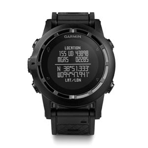
The new watch is called the tactix and it retails for $450. It sports a high-sensitivey GPS sensor with automatically calibrating altimeter and a 3-axis compass. It's built in memory allows the device to store up to 1000 waypoints and 10,000 track points, and allows the wearer to quickly and easily retrace their steps back to previous positions. In a nod to its military roots, the U.S. version of the watch is preloaded with tidal data and all versions include Jumpmaster software for airborne personnel. It also features sun/moon data and a calendar for hunting and fishing. A stopwatch, countdown timer, world clock, and alarm functionality are all built in as well of course, and as with most GPS enabled watches, this one will tell you distance traveled, speed, calories burned, etc. The tactix will also pair with Garmin's heart rate monitor and bike pod to measure performance and will even control the company's VIRB and VIRB Elite action cameras.

The tactix is designed to be rugged and survive in the outdoors. Its case is tough and durable, making it water resistant down to 50 meters. It's all black styling is designed to be non-reflective and subtle in nature, while the built in battery can reportedly go 50 hours between charges with GPS enabled and 5 weeks when being used as a standard watch. That performance is actually quite good for a watch of this kind.

The new watch is available now.

Google Brings Street View To U.S. And Canadian National Parks

I've always been a big fan of Google's Street View technology. It's the amalgamation of the excellent Google Maps and photos that are taken and geo-tagged at various locations around the planet. The results are that we can explore a map from above then with a simple click, zoom down to street level to see exactly where it is we'll be traveling. It can be tremendously useful when visiting a place for the first time and it is often fun to explore an area right from your computer.

For some time now Google has been using the Street View tech to map some really cool locations. For instance, you can visit the Galapagos Islands, the Great Barrier Reef and even Everest Base Camp directly from your browser. But today, the Internet search giant has announced that by working with the U.S. National Park Service and Parks Canada, 44 national parks have been added to Street View as well, allowing us to take a virtual escape to those destinations even when we don't have time to actually go ourselves.

Some of the locations that been added include Sequoia National Park, Joshua Tree and Mt. Rushmore. You can also pay a visit to such historical landmarks as the Alamo, the Lincoln Memorial and the National Mall in Washington DC. If you're looking to head north of the border, check out Moraine Lake and Lake Louise in Canada's Banff National Park as well.

Of course, I'd never even begin to suggest that Street View is a viable option for going to visit these places for yourself. It is however, fun technology that allows you to scout ahead before you actually go in person. It is also a nice way to escape the office, even if for just a few minutes, during a particularly long and boring day. It is also a nice reminder of how far we have come in terms of mapping technology. I hope Google continues to expand on these initiatives in the years ahead.