Cheong-Gyesan Jang in Sujeong-gu

Hot Coals

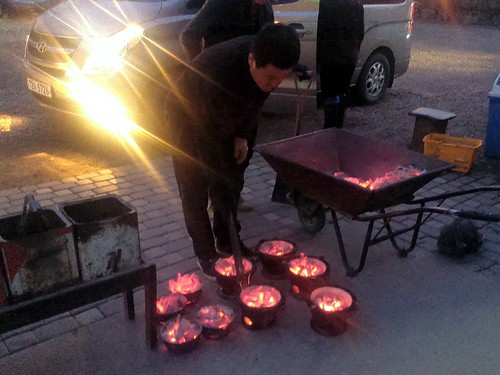
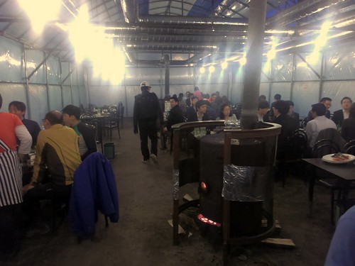
That was pretty cool. Some of our teammates have been talking about this place for a while now, so I suggested that we come here for dinner. Yes, the food was good (and prices cheap), but the more interesting thing about this place is the venue itself, which is out in the middle of nowhere and requires a bit of a drive out of Seoul (212-5 Sangjeok-dong, 31-723-9938).

Outdoor Korean BBQ

See, one can choose to eat outdoors on the gravel with light bulbs dangling overhead. It was a bit cold tonight so they enclosed the dining area with plastic sheets to keep the heat in, but I can imagine that this would be even more fun during warmer days when presumably everything is just out in the open air. The charcoal kept us warm at least...as well as the copious amounts of soju.

Korean BBQ

Tony's Pizza on River Valley in Singapore

Pizza

I'm a bit torn about this place (397 River Valley Road, 6777-4992). On one hand, I absolutely hate how overpriced it is at S$6.50 (US$5.15) for a slice of cheese pizza that hardly puts a dent in my stomach. And S$4.50 (US$3.50) for a glass of watered-down lemonade? Bah! Every time I come here, I tell myself that I'll never go back.

And yet, I've been back here at least two or three times, in part simply out of sheer convenience, but also since there really isn't anywhere else around here that one can get a New York-style pizza by the slice, complete with oregano and garlic powder at each table. Admittedly it does smell pretty good in there when you walk in. (Where is the parmesan shaker, BTW??)

Either way, I keep cringing each time the cashier tells me how much I owe them. Yes, I know that it's not fair to compare to prices in New York when we are halfway around the world, but it still irks me. Surprisingly, I've seen multiple people paying at least S$42 (US$33) for an 18" pie there...and lots of bike deliveries too. Maybe next time I'll stick to their buffalo wings instead.

Clonfert Cathedral, County Galway

For daily updates on Ireland's wonderful heritage please follow us on Facebook, Twitter, Google+ and Instagram

Clonfert Cathedral in County Galway is probably best known for its amazing doorway, the finest example of Romanesque architecture in Ireland. The Romanesque style of architecture was influenced by classical Roman and Byzantine architecture, and generally dates to the early medieval period, some time between the 8th - 11th Centuries AD across the continent. It appears a little later in Ireland, and seems to coincide with large scale reforms of the Irish church in the twelfth century. The Irish builders incorporated their own styles with Romanesque to create a hybrid of the two, which is known as Hiberno-Romanesque architecture. 

A close-up of the carved heads

The doorway at Clonfert is in six ‘orders’ and has inclined jambs. Above the doorway, a steep triangular pediment is covered with Romanesque decoration showing animal heads, foliage, zig-zags, chevrons, but most striking of all are the individually carved human heads.


The wonderfully ornate Romanesque decoration
However striking, the Romanesque doorway was a late addition onto a church that was already famous in Ireland. It is referred to in the annals before 1050 as one of the four largest churches in the country (Annals of the Four Masters, Annals of Inishfallen, Chronicon Scotorum). Clonfert is associated with Saint Brendan, he is said to have founded a monastery here in the sixth century. Brendan is known as The Navigator, and is one of the most famous of Ireland’s monastic saints. 

A ninth century book The Voyage of Saint Brendan the Navigator records his legendary journey to ‘The Isle of the Blessed’, a journey that involves sea monsters, strange islands and their inhabitants and that some people even believe to suggest that Brendan was the first European to discover America! There are no remains of Brendan’s monastic site visible at Clonfert, though a gravestone in the churchyard marks the spot where he is allegedly buried.


15th Century sculpture, note the mermaid at the base
As you pass through the doorway into the cathedral you can notice that the innermost part of the doorway is a later medieval (around the fifteenth century) addition, carved of grey limestone in contrast to the sandstone of the flamboyant Romanesque door. Much of the fine carvings and archway in the interior are also of fifteenth century date, and see if you can find a charming carving of a mermaid dating to this period too. She is similar to that at nearby Clontuskert.  
Clonfert is certainly worth a visit to see the spectacular Romanesque doorway and the wealth of later fifteenth century sculpture inside. You’ll find it around 15km south-east of Ballinasloe, when you get to Laurencetown it is signposted down a minor road to the east off the R355 (Ballinasloe – Portumna Road). At co-ordinates 53.240651, -8.058621.

You can find more information about Clonfert from their website http://www.clonfertdiocese.ie


The interior of Clonfert


If you have a suggestion for a site I’d love to hear it, please let us know by dropping us a line at info@abartaaudioguides.com or on Facebook, Twitter, Google+ and Instagram where you can keep up with daily pictures and information about Ireland's wonderful heritage sites.If you'd like to support us please consider downloading one of our audioguides from www.abartaaudioguides.com, they are packed with great facts, information, stories and legends from Ireland's iconic sites. They are designed to be fun and informative whether you are visiting the sites or from the comfort of your own home, so if you are looking to escape to the Court of Brian Boru the next time you are doing household chores download one of our guides and let us whisk you off to ancient Ireland!


My Work: Orissa & Chhattisgarth

Photo © Tewfic El-Sawy-All Rights Reserved

Photo © Tewfic El-Sawy-All Rights Reserved

Here are two images made while traveling in Chhattisgarh and the neighboring Orissa. There were made using my first digital camera, the Canon 10D...remember that one?

The first is of an Odissi dancer in Bhubaneswar. Odissi is one of the eight classical dance forms of India. It originates from the state of Orissa, in eastern India. On the basis of archaeological evidence, it's the oldest surviving dance form of India.

The second is of an adivasi in the Bastar region of Chhattisgarh, whom I found amongst the thousands of tribal people who congregated at one of the weekly haats. It's estimated there are 300 haats in Bastar, where villagers come to buy basic necessities, and to socialize.

It's at these haats that the adivasis imbibe copious quantities of toddy, the palm wine ubiquitous in these parts. The fellow was in a pseudo trance along with other members of his group. Despite my efforts, I never found out what the purpose of the trance was.

Here's my gallery The Adivasis of Chhattisragh.

Video: Adventure On Fast Forward

The pace of the video below would best be described as "breakneck." Once it takes off, there is barely time to catch your breath as it speeds through a series of beautiful and adventurous timelapse segments. The title of the video is "Pause #24" but really its adventure in fast forward.

PAUSE #24 from PAUSE on Vimeo.

POV: Children Should Never Go Hungry

Photo © Tewfic El-Sawy -All Rights Reserved

The Zocalo, with its cultural activities, is the very heart of Oaxaca, and is a daily magnet for locals and tourists alike. It also attracts vendors of various trinkets, as well as poor children (all of them indigenous...possibly Zapotecs) who attempt to make a few pesos by selling chewing gum. Approaching the restaurants' tables occupied by tourists, these children sometimes shyly ask for left-overs. In fact, that's what three little girls did one evening. We gladly gave them whatever was on our table, and one of us even asked our waiter for a bag to give them half her pizza.

During a festive Guelguetza dance festival of schoolchildren, I looked beyond the colors, music, laughter and frenetic motion, and at the periphery of the stage, saw a Zapotec boy with arms outstretched in askance for fruits from one of the young dancers.

You see, after each dance the young dancers would reach into baskets of fruits, flowers and vegetables, and toss them to an appreciative audience. The Zapotec boy was in that audience, and wanted fruit. Mind you, not for keepsake as perhaps the families wanted, but to eat. However, I also noticed he never reached into the basket full of apricots just inches from him...no, that would be stealing. He just wanted the young dancer to give him one...and he got a fruit.

Not only was I sobered at this sight, but I also read in these unfortunate children's eyes an uncomprehending acceptance that they would never take part in an organized Guelaguetza dance such as the one they were witnessing. I also sensed that they understood that it was so because they were poor and were racially different. They would never wear the colorful Guelaguetza costumes. All this boy could muster was an old over sized baseball cap, and a dirty shirt.

No child should go hungry and no child should beg for food. Ever.

My post on McCurry's taking a celebrity photography project was criticized on another blog by a handful of readers as being misplaced, rude and judgmental...which puzzled me since I specifically wished him the best of luck with his new project, and described him as a pioneer and an inspiration to many.

The thrust of my post was not about McCurry or his future but to stress the need for all of us to diversify by learning and using multimedia, FCB and Soundslides...and not remain stale and repetitive. In fact, here's a quote from the post which encapsulates my point of view:
"McCurry is one of the pioneers of travel photography and is an inspiration to many who follow his style....and to read of this new project is an uncomfortable reminder that things are changing in this industry, and that photographers (whether involved in travel, documentary and editorial) need to be sharp, varied and inventive."
So to these half dozen readers I make no apologies nor do I need to rethink/reword a single syllable of my post. Not only did you misunderstand my post's intention, but dismissed it as a rant (my POVs always are), denigrated my photography (I do that all the time so get in line and get a number), sneered at my having been a banker in my previous life (many people have more than one career, so I don't understand your point unless, God forbid, you're envious) and so on. Heck, even my country of birth was mentioned...what does it have to do with my blog posts unless it's a jingoistic innuendo? Yes, the mind boggles.

Let me also say that one of my readers also misunderstood what I meant, and had the courtesy of emailing me expressing his viewpoint, and asking for clarification. I responded, and we ended up agreeing on certain issues and disagreeing on others.

As for my pontificating, as a couple have described my post(s), that's exactly what I do here on this blog. That's what this blog is about and will continue to be. You don't have to pay any attention to it. If it aggravates you, just improve your life and remove it from your reading list, because the mission of this blog is to pontificate and to support emerging talent...period. If you don't like it, just don't read my "rants" and "pontifications"...it's really that easy. I'm only a banker-turned-photographer after all...remember?

However, I'm so enamored by the term that I will soon change the sub title of this blog to include it...perhaps like acerbic pontification...or acerbic soap boxing...thank you for the unintended suggestion!!

New Note: I have to thank all of those who emailed me expressing their support and sharing their unbridled puzzlement at the criticisms, and to those new friends who, as a consequence of all this, have now joined my newsletter mailing list! No new post today...i want to keep this one up for a while.
Looking for a little escape at the start of the week? Then look no further than this great travelogue style video that follows three traveler as they ride from Jaipur, India to Khardung La, the highest road in the world at 5369 meters (17,582 ft). It is a colorful, chaotic journey that looks like it would be quite an adventure.

The exposed chamber of one of the tombs, with the larger cairn topped by an Ordnance Survey point in the background

On Saturday (15th March 2014) we visited Seahan, another of the megalithic tombs of the Dublin and Wicklow Mountains. At Seahan [sometimes spelled as Seehan] you can find the remains of two large stone cairns. They probably date to the Neolithic period, around 5,000 years old, a time when people first began to clear the ancient forests to create fields for farming. They are thought to be the remains of passage tombs, a type of burial monument that appears as a round mound of stones or earth, ringed by large stones set on their edges to form a kerb. Parallel lines of upright stones formed a passageway leading to a chamber which usually contained the remains the dead. 

One of the cairns on Seahan has a very clear kerb of stones surrounding it, but it has been disturbed, possibly in antiquity. It is situated adjacent to a larger cairn that has an ordnance survey point added to its summit. Its possible that some of the stones of the exposed tomb were used in the construction of this large cairn. Archaeologist Christiaan Corlett suggests that perhaps this raises some interesting questions about the relationship of the two tombs – perhaps the people constructing the larger cairn deliberately ‘slighted’ the older tomb to construct a new larger cairn. Perhaps as a way of symbolising their ascendancy over the people who are interred within the smaller tomb and their descendants who built it.
The Ordnance Survey point that has been added to the top of the larger cairn on Seahan.
The cairns on top of Seefinghan (left) and Seefin (right) visible from the tombs of Seahan
Seahan appears to be part of an extended series or cemetery of passage tombs that cover a number of peaks in the area. From Seahan you can clearly see the cairns on top of Seefingan and Seefin. Building these tombs so high in the Dublin and Wicklow mountains must have been an incredibly difficult undertaking in the Neolithic period even though there is an abundant supply of stone on top of the hills. The peaks of these hills are all around 650m – 750m above sea level, so why would they have constructed these elaborate and large stone tombs up here? 

Expansive views over Dublin from the summit of Seahan
We can never say with certainty, but perhaps like a lot of cultures around the world, they believed that to be buried in these high places was to be closer to their gods. Personally though, I think that it was a statement of ownership over the landscape. From this high vantage point the whole of South County Dublin and Wicklow is visible. Green fields, rivers, lakes. Perhaps they believed that any newcomers to this fertile territory would see the very visible tombs in the distance and know that the people living here have done so for millennia. Or maybe they believed that by placing their ancestors far above the low lying lands of the living, the shades of their forebears could watch over them from their tombs. For those interested in prehistoric archaeology, or those who love a bit of hillwalking, or those who just want to see some of the finest views in Ireland, Seahan is a real must-see. 

The Famine Cross, take the road to the left of this monument.
I strongly recommend you use OSI Discovery Series Mapping Numbers 50 and 56 to help you find the tomb easily. To get there exit the M50 at Junction 12 Firhouse. Travel on the R113 towards Oldbawn. Take the left turn for the R114 signed for Bohernabreena. Continue straight on this road, staying right at the slight fork at Bohernabreena. Drive past the golf club on your left and take the road to the left of a famine cross you will see on the left hand side of the road. Continue on this road for about 5 minutes. On a clear day you will see Seahan on top of the mountain to your left and Seefin and Seefingan ahead. Seahan is separated from Seefinghan and Seefin by the Army Rifle Range, if you see signs for that you have gone too far. There is a parking area below Seehan in front of large boulders. Park here and walk along the path. Take the first left on this path - this will lead you up to the summit of Seehan. We had great weather for our visit, but I wouldn’t recommend the trip in poor conditions. It was about a 25–30min fairly easy stroll up the Mountain to the site, but good boots are recommended. Above all though, please do be aware of the Army Rifle Range and respect their warning signs! 


If you'd like to support us please check out our acclaimed series of audioguides to Ireland’s heritage sites, they are packed with original music and sound effects and a really fun and immersive way of exploring Ireland’s past. They are available from www.abartaheritage.ie.
If you’d like to receive daily updates and images of great heritage sites then please consider following us on Facebook, Twitter and Google+.


Some Sources and Recommended Reading:

Corlett, C. 2012. The Megalithic Tombs of South Dublin, Archaeology Ireland Heritage Guide No.57. (Wordwell, Ireland)
Cooney, G. 2000. Landscapes of Neolithic Ireland (Routledge, London)
Waddell, J. 2000. The Prehistoric Archaeology of Ireland (Wordwell, Ireland)


All photographs and text © Neil Jackman / www.abartaheritage.ie
The stunning landscape of the Dublin Mountains, like a different world and less than 30mins from Dublin!

Antarctica 2013: Still Waiting

The weekend wasn't particularly kind to the teams still waiting to get their Antarctic expeditions under way. Poor weather across the region is still causing major delays and it looks like it may be another few days before things start to improve. This has left a log jam in Punta Arenas, where a number of explorers are still waiting for their flights out to the frozen continent so that they can get underway at last. The weather also continues to delay some expeditions that are already in the Antarctic but have yet to get officially started as well.

At the moment, Chris and Marty Fagan, Lewis Clarke, Daniel Burton, Antony Jinman, and various others are all waiting for flights to Union Glacier. Flights were scheduled to resume over the weekend, but the weather continued to be an issue, so they've been pushed back into this week. It is now believed that the forecast will clear up in the next day or two and these teams can finally head out. But until they are actually on the flight, no one is particularly sure when they'll get to go.

They're not the only ones who are still waiting to get underway either. It seems Richard Parks is still looking for a weather window to launch his attempt on the speed record for skiing to the South Pole from hercules Inlet. He has been at Union Glacier for nearly two weeks now and has now been radio silent for a week. I have to assume we'll hear something from him once he actually begins the journey, but for now he seems to be content to sit and wait for a clear window. That could be awhile considering how fickle the weather is in Antarctica.

Also delayed by weather are the three teams taking part in the South Pole Allied Challenge (who also appear to have let their domain expire!). They flew to the Novo base at the end of last week and were scheduled to catch flights to the 87th degree over the weekend, but are now locked in place due to storms. Once they get the clearance to get underway, the three squads will then embark on a race of sorts, with each of them covering the last three degrees to the South Pole.


Geoff Wilson was able to put the major crevasse field that he had been navigating behind him, but the winds have been a bit cruel at times. He is kiting to the South Pole and has had to alternate between dragging his sled on skis at a painfully slow pace and catching brisk winds that allow him to fly across the ice. At times his progress has been unbearably slow and at others he has seen solid progress. All in all, he was happy to make some milestones this weekend and he seems to be getting much more comfortable with his kite now. That means, if the winds are in his favor, he could potentially make good time in the days ahead.

The Scott Expedition hit a milestone of their own yesterday. Ben and Tarka have now been out on the ice for a full month and to celebrate they had a chance of underwear and a bath of sorts. That came as some relief, as they have been battling strong headwinds for the past few days and while they continue to make solid progress, they've had to work hard for those miles. According to the statistics posted on their website, the boys still face more than 1500 miles (2414 km) on their journey to the South Pole and back, which has to be a bit unsettling considering the amount of time they have spent out on the ice already. But their mood seems good despite the challenges they've face thus far. Hopefully things continue to go well in the weeks ahead. They still have as much as two more months to go before the end.

That's all for a Monday update. I know you've been hearing me say that these other expeditions will get underway soon for several days now, but once again the weather is the final deciding factor. Hopefully this week will be more kind to the teams and we'll get more updates from the Antarctic soon.

Antarctica 2013: More South Pole Skiers Hit The Ice

Now that the storms in Antarctica have subsided – at least for now – the regularly scheduled flights to the continent are underway and more skiers are hitting the ice to start their journeys to the South Pole. With the big Ilyushin aircraft reaching both the Union Glacier and Novo bases within the past few days, the 2013 Antarctic expedition season is in full swing at last with multiple expeditions preparing to head south, including a high profile speed attempt that should start today.

Richard Parks, the Brit who hopes to set a new speed record for skiing to the South Pole, should now be ready to begin that epic endeavor. He'll begin at Hercules Inlet and hopes to cross the 1150 km (715 mile) distance in just 23 days. Parks left Union Glacier two days ago and after a day of prepping gear and getting ready to start, he should be underway today. There has been no update yet on his official start, but I would anticipate confirmation soon. Once we get that notice, he'll have just over three weeks to reach his goal, which means he'll have to average about 30 miles per day en route. That's a pace that seems nearly impossible to maintain in the unpredictable Antarctic. I certainly wish him luck in this attempt however and will be cheering him on.

Meanwhile, the Novo Station welcomed two new arrivals yesterday. According to ExWeb,  Geoff Wilson and Faysal Hanneche were delivered to the Antarctic today and are now putting the final touches on their preparation before they launch their expeditions as well. Wilson is attempting a solo ski journey to the South Pole to raise funds for nurses that specialize in breast cancer back in his home country of Australia, while Hanneche will be kiteskiing to the Pole on his own as well. The Aussie left Novo yesterday but only went a short distance away from the base before setting up camp. I imagine he'll have his first full day out on the ice today or tomorrow.

ExWeb is also reporting that all of the gear for the upcoming Walking With The Wounded South Pole Race was delivered to Novo yesterday as well. The event will consist of three teams of wounded vets on a ski race to the Pole. One team is from the U.K., another from the U.S. and a third from the Commonwealth States. The participants will have a kick-off party in London tomorrow before heading out for Antarctica, but their gear will be flown to their starting points soon and will be waiting for them to arrive. The three teams will ski just the last three degrees on their way to the bottom of the world.

Finally, the Scott Expedition continues to press forward although it hasn't exactly been an easy start to their journey. Ben and Tarka are closing in on three weeks out on the ice and their spirits have risen and dropped from day to day depending on conditions and distances covered. Yesterday the sun came out, which made them feel better but the struggles of pulling heavy sleds, day-in and day-out, have taken their toll. Still, those sleds get a little lighter each day and as they make supply caches for their return trip, they sometimes get substantially lighter. They have a long way to go yet but the boys seem to have found a rhythm which will serve them well in the days ahead.

As a side note, if you haven't been reading the Scott Expedition blog posts, I'd definitely recommend them. Most days they answer questions from those of us who are following along at home and their answers can be quite interesting and enlightening. Many of them are about the logistics of Antarctic travel with some great information being shared directly from two guys who are out on the ice. It is hard to find better insights than that.

More to come soon.

Travel Warnings Go Up For Mexico-- Should You Pay Attention?

Roland on a Guanajuato backstreet

This evening the U.S. Government's Bureau of Alcohol, Tobacco, Firearms and Explosives issued a warning, specifically to young Americans looking for a good time in Mexico, to avoid Tijuana and Rosarito, just south of San Diego. With spring break coming up, college students traditionally flock to Mexico resort towns. The ATF thinks the drug-related violence should make them change their plans.
The bureau's Los Angeles field division said Monday that it discourages travel to Tijuana and Rosarito Beach, noting that both cities just south of San Diego have witnessed a lot of drug-fueled violence. Rosarito has long been a mecca for Southern California students on spring break.

The warning goes a step further than one issued by the State Department last month advising travelers to Mexico to avoid areas of prostitution and drug-dealing and to take other commonsense precautions.

I just got back from an awesome trip to San Miguel de Allende, where there's pretty much no violence, drug related or otherwise. It's as peaceful a town as you're likely to find anywhere. And not the kind of place I'd expect to see many spring break partyin' fools either. There are some pretty wild art galleries but... that's about as wild as it gets.

Seven months ago I was in Mexico City and that was pretty easygoing as well. I mean from what you read, Mexico sounds like the killing fields. Last week I did a post at DownWithTyranny about how catering to irrational gun worship in the U.S. has led to a dangerous deterioration of law and order south of the border. But over all, I found Mexico City just as safe as any other large city anywhere. If you're looking for trouble, you'll find it. If you're awake to the world around you, unless you run into some incredibly bad luck, you'll be fine. Same as in L.A. or Milan or Hong Kong.

Mexico has the 12th biggest economy in the world and the trade been the U.S. and Mexico-- the legal, non-drug, non-contraband weapons-- is almost a billion dollars a day. Our economic vitality and security is much more closely tied to Mexico than most Americans realize. And the drug cartel-related violence has a lot to do with this side of the border. The market for illegal drugs is here. And the heavy weapons that leaves the Mexican police unable to maintain law and order come from the U.S.

The Mexico Travel Board says the tourist destinations in Mexico are as safe as they've ever been and hotel occupancy rates were pretty strong in February: 73% in Cancun, 85% in the Riviera Maya, 78% in Puerto Vallarta.
Mexico remains a safe tourist destination and this is reflected in the 22.6 million international visitors that arrived in 2008, of which 18 million were Americans. This number represents a 5.9 percent increase from the previous year. Tourists who suffered any incidents were minimal.

The violence associated with drug trafficking is isolated in cities that are far away from tourism destinations. We suggest using common precautions as when traveling to any foreign country.

Q: Is Mexico an unsafe place to travel?

Mexico ranks tenth as an international travel destination in the world and is the number one international tourism destination for North Americans traveling abroad. Many tourists to the country are repeat visitors, which demonstrates that the vast majority of tourists are satisfied and leave with overwhelmingly positive impressions.

One other thing, the dollar/peso exchange rate was around one dollar for 10 pesos for many, many years. This year it went to 14 pesos for a dollar, making everything incredibly cheap(er) for tourists. And today it went over 15 pesos to the dollar!

While I was away from my computer for parts of last week, the team at impossible2Possible launched a new youth expedition, this time sending a group of students on a run through Peru. The aptly named Expedition Peru got underway last Wednesday and should wrap up today after the five students involved have run from the heights of the Andes all the way to the Amazon Rainforest, one of the most ecologically diverse places on the planet.

As is typical with any i2P project, this one has multiple objectives, not the least of which is promoting the importance of large ecosystems like the Amazon for the health of our planet. The team has been educating others about the diversity of life that exists in the rainforest and the treats that those species face from the encroachment of man. The expedition has also promoted strategies for protecting these ecosystems in the future to ensure that the Amazon isn't damaged irreparably.

Education is always a key element for an i2P project as well and this one is no different. Throughout the expedition the team has interacted with numerous classrooms back home, sharing valuable insights about their experiences with students. Adventure has always played a key role in engaging those students with the message that the impossible2Possible team is promoting, with the hope of inspiring them to pursue their own adventures while gaining more knowledge on a specific topic.

For nearly a week, the five i2P youth ambassadors have run a marathon per day as they traveled across some of Peru's amazing landscapes. The journey started in the mountain town of Cusco, famous for its ancient ruins and sweeping views of the Andes mountains. Over the course of the run the team made their way to Manu National Park, a remote and diverse ecosystem that has been preserved to protect the wide variety of species that live there.

For an idea of what the expedition has been like for the runners, check out the video below.

Expedition Peru Day 4 & 5 from GOi2P on Vimeo.

Lightroom 3's Ice Climbing Ad


It's only because I like Lightroom a lot and use it virtually all the time that I agreed to post this advert on The Travel Photographer's Blog. As my readers know, I don't place any ads on this blog, but I occasionally write on products that I like and use...and Lightroom makes that cut.

Tyler Stableford is an adventure photographer, and was given the challenge of shooting an ice climbing expedition and perfecting his images with the help of Lightroom 3 beta 2.

Government Shutdown Ends - National Parks Reopen, Antarctica Still In Doubt

By now I'm sure you're all well aware that the shutdown of the U.S. government has ended and all services are being restored. This is, of course, a good thing for not only the States but the rest of the world, because if a budget compromise hadn't been reached by yesterday, the U.S. would have defaulted on its debt, causing all kinds of economic issues across the globe. Fortunately that didn't happen and some semblance of normalcy can return one again.

With the standoff between Democrats and Republicans over (at least for now!) the federal government began ramping up operations once again on Wednesday evening. As a result, all of America's national parks are open once again and visitors have already been flowing through their gates. With the fall travel season in full swing, this is good news for everyone who enjoys the outdoors and it means that we are no longer officially shut out from some of the most spectacular landscapes in North America, if not the world. I say "officially shut out" because many visitors to the parks ignored barricades and went inside during the shutdown anyway.

The news is not so rosy for the researchers and scientists hoping to travel to Antarctica this season. As I mentioned previously, the shutdown forced the government to put several Antarctic bases into "caretaker status" which essentially reduces everything to a skeleton crew and maintains the bare minimum or resources. Ramping back up from that isn't as easy as removing barricades and opening gates, as there are a lot of logistics that go into supplying those bases and ensuring staff can arrive there safely. Most of those plans were canceled or put on hold pending resolution to the budget crisis, and since those schedules are so tightly set, getting back on schedule is an uphill battle.


The National Science Foundation is currently evaluating its options and working to get back into service. As of this writing, their website still isn't even functional. From what I understand, they'll spend the next few days figuring out which Antarctic projects have priority and determining what funding they'll have available, before deciding on how to proceed.

If I were to guess, I'd day we'll see a paired down Antarctic schedule for the season ahead. Some projects will still be salvaged but others will have to be delayed until next year or beyond. Operations will likely ramp up much more slowly than normal and will probably be at a much lower capacity. We'll just have to wait to see how things play out, but with the Antarctic expedition season about to commence, decisions will need to be made quite quickly.

I, for one, am glad to have the parks back in operation and at least some movement in Antarctica. Now if we could just get some people to move in Washington, things would be much better all around.

Kilcooley Abbey, County Tipperary

If you'd like to see daily images and information on Ireland's incredible heritage sites please consider following us on Facebook, Twitter or Google+

One of Ireland’s true hidden gems, Kilcooley Abbey is a simply wonderful place to visit. It is located in the beautiful Sliabh-Ardagh region of Tipperary, and is located within the walls of the Kilcooley Estate, an impressive Georgian house with over a thousand acres of land.

Kilcooley Abbey was founded in 1182 after a grant of land to the Cistercians by Donal Mor O'Briain, King of Munster. It was the ‘daughter house’ of Jerpoint Abbey in County Kilkenny, and Kilcooley is without a doubt one of Ireland’s finest Cistercian abbeys and is a wonderful example of Gothic architecture. 

The Cistercian Order was founded by St. Bernard of Clairvaux in Burgundy, Central France in 1098. St. Bernard believed that the other monastic orders had become dissolute and undisciplined, and he founded the Cistercians as an austere and hard-working order who focused on a life of prayer. The Cistercians were initially extremely successful in Ireland, and spread rapidly from their first foundation at Mellifont in County Louth.


I haven’t been able to find much on the next couple of centuries of Kilcooley’s history, but the Abbey is recorded as being attacked and burned in 1418 and later again it was recorded as being almost completely levelled by an armed force of men in 1444. After this attack, the Ormond Butlers instigated a programme of reconstruction which removed the nave aisles and added a new north transept and tower. Most of the stunning sculpture around the Abbey dates to this period of reconstruction and renovation under the patronage of the powerful Ormond Butlers. The works were carried out under the eye of the Abbot, Philip O’Mulwanayn, and his graveslab dating to 1463 shows him holding his bishop’s crozier and book of prayer. He appears to have been part of a dynasty, as his son William, and his ancestors after him, were abbots of Kilcooley until the mid sixteenth century.
The Butlers were rewarded for their patronage, by having their tombs placed inside the sacred areas of Kilcooley. The most stunning of which is the incredible tomb of Pierce Fitz Oge Butler. The tomb likely dates to 1526, and depicts Pierce Butler in his armour. At his feet a small dog indicates his faithfulness and loyalty, and ten of the twelve apostles are depicted below (from left to right) Saint Peter holding the keys to Heaven, Saint Andrew, Saint James (major), Saint John, Saint Thomas, Saint James (minor), Saint Philip, Saint Bartholomew, Saint Simon and Saint Matthew. Unusually, we know who actually created the tomb, as the name of the sculptor Rory O’Tunney (Roricus O Tuyne) is clearly marked.

The Sedilla
The wonderful screen wall


The beautiful eastern window
Medieval tomb effigys, with that of Abbot Phillip O’Mulwanayn highlighted
It is almost impossible to do justice in this short blog article to the sheer wealth of incredible sculpture at Kilcooley, for example the beautifully ornate Gothic east window is so delicately carved, with the stone formed to look almost like flames or delicate foliage.  The ‘abbots chair’ (or sedilla) is also incredible, and is matched on the other side by another, slightly plainer example perhaps for a prior. As far as I am aware I believe them to be the only examples in Irish Cistercian monasteries.

The screen wall separating the southern transept from the sacristy is also elaborately decorated with a number of scenes including Saint Christopher crossing a river with the infant Jesus, the crucifixion with Mary and Saint John on either side, a pelican feeding its young within a chalice, a charming mermaid with a comb and mirror, and the Butler coat-of-arms.
The cloister area

Beyond this area you can enter the cloister. The cloisters was an important feature of Cistercian monasteries, and were always located to the south. They were usually a covered walkway enclosing an open square area. Very little remains of any covered walkway at Kilcooley, and it appears that perhaps the cloisters were converted to a courtyard in its later history. You can see other more domestic quarters at Kilcooley though some of these are kept locked and inaccessible to the public for health and safety reasons. Outside of the abbey you can see a small circular tower, this was a dovecote where the monks kept pigeons. The pigeons were a handy source of protein and the pigeon dung also made good fertilizer, very little was wasted in a medieval monastery! In its heyday, the Abbey would have also had other agricultural buildings like mills and a large lay population to work the land.
Stairway to domestic quarters

Kilcooley Abbey ceased to be a place of monks and contemplation when it was surrendered during the Dissolution of the Monasteries in 1540. However the lands were granted directly to the Butlers, and it is recorded that they allowed monks to remain at Kilcooley, until they sold it to Sir Jerome Alexander in 1636. After the Catholic Confederacy rebellion in 1641, Cistercian monks returned to Kilcooley, until they were finally removed from the site by Cromwell’s forces in 1650. Ten years later the Alexander family regained the Abbey and when Elizabeth Alexander married Sir William Barker of Essex in 1676, the Abbey was converted into being a domestic house.

In 1790 the grand Kilcooley House was built and replaced the abbey as the main residence. Today the site is a National Monument, and under the care of the Office of Public Works. The site is gated, but the gate is often left unlocked during the day to allow visitors to enjoy one of the finest heritage sites in the country.

Kilcooley is located around 20km east of Thurles in County Tipperary at co-ordinates 52.67206 -7.5644, off the R690. It’s just east of Gortnahoe. When you go up the drive of Kilcooley Estate you’ll see signs for the Abbey, but before you get there be sure to park your car at the relatively modern Church of Ireland and take a moment to see the quite remarkable 18/19th century pyramid shaped burial monument of the Barker family. It’s well worth a look! The abbey is just further along the track, less than a five minute walk from there.

Kilcooley is one of the sites on our free to download audioguide The Derrynaflan Trail, that leads you around the beautiful Slieveardagh Region of County Tipperary and helps you to explore the wonderful ancient monasteries and churches that you will encounter along the way. Download directly to your smartphone or tablet with our free audiovisual app (for Apple and Android), please see here for a preview.

Alternatively you can download directly onto your desktop or laptop as a free MP3 album, please visit here to download your free copy.

The dovecote
The fantastic Historic Graves group have also visited Kilcooley and have recorded the custodian of the Abbey eloquently describing the history and features of this remarkable place. You can find this here

If you have a suggestion for a site I’d love to hear it, please let us know by dropping us a line at info@abartaaudioguides.com or on Facebook, Twitter or Google+, where you can keep up with daily pictures and information about wonderful heritage sites in Ireland.

If you’d like to support us please consider downloading an audioguide from my website www.abartaaudioguides.com. They are designed to be fun and informative whether you are at the site or from the comfort of your own home. Try our audioguide to Viking and Medieval Dublin, or if you’re in Tipperary try our guides to the Rock of Cashel or the formidable Cahir Castle. Available for just €1.99 from www.abartaaudioguides.com
The unusual pyramid monument of the Barker family
 
The impressive Kilcooley Estate, dates to the 18th Century and available for €2.1m


It took a while, but I completed setting up two websites based on the popular WordPress F.8 theme that will run in parallel to my current website.

The first WordPress-based website contains 15 photo galleries, which are also iTouch and iPad-compatible.

The second WordPress-based website contains 8 audio-slideshows.

The Travel Photographer's original HTML/Flash-based website still remains as is.

Xiao Manniu Mala Xiangguo at Star Vista

Mala Xiangguo

When I first saw this place (1 Vista Exchange Greem #02-25), I was excited to see yet another mala xiangguo stall at a foodcourt, hopefully being a sign of more to come. But this one was kinda nasty, as it lacked the punch of Sichuan peppercorns...and was surprisingly watery at the bottom! One of these days we should try that stall that I saw at Jem to see if it is any good.

Addendum: I just came back to this place four weeks later, and realized that if one requests the spiciest level, then the dish finally becomes bearable enough to eat. I'd still prefer to go elsewhere, but if I'm stuck here, then the trick is to request the highest level of heat.

Albert Kahn: It's A Wonderful World....


Not all bankers work for "great vampire squids wrapped around the face of humanity". Well, some may enjoy doing just that, reaping millions in the process...but others may be like Albert Kahn.

Certainly a product of a different age but Albert Kahn was a wealthy French banker and philanthropist, who started an visionary project to create a color photographic record of the peoples of the world.

Described as an idealist and an internationalist (aren't these two words synonymous?), Kahn used a new photographic process called autochrome, to promote cross-cultural peace and understanding.

Camera-shy himself, Albert Kahn used his fortune to finance the travel of intrepid photographers to more than 50 countries around the world, at a time when age-old cultures were on the brink of being changed for ever by war and the march of 20th-century globalization. His objective was to record the differing customs of the human race for posterity, and his Paris museum houses 72,000 autochromes of these travels.

Although Kahn was one of the richest men in Europe in 1929, Wall Street's crash that very year ruined him, and in 1931 he was forced to bring his project to an end.

A BBC book The Wonderful World of Albert Kahn was published, bringing Kahn's autochromes to a mass audience for the first time. A wonderful world indeed.

Perhaps Lloyd Blankfein of Goldman Sachs will pick up Albert Kahn's baton?

(The vertical autochrome is of a Vietnamese couple in Tonkin in the northernmost part of Vietnam, while the horizontal is of a hunter in Mongolia).

Outdoor Weblog Interviews The Crazy Kayaker!


I first blogged about The Crazy Kayker last week when he announced his plan to kayak the length of the Mississippi this Summer. Well, our friends over at The Oudoor Weblog have gone a step further by posting aninterview with him.

In the first installment of a new section entitled "The Outdoor Enthusiast Next Door" they put the questions to Jacob van der Merwe, a.k.a. The Crazy Kayaker. This is part one of the interview, and Jason answers questions about how he got his nickname, why he loves kayaking, and why he wants to kayak the length of the Mississippi River. His answers are interesting and insightful and give us a nice glimpse at his personality.

It should be fun to follow his progress this Summer, and if I still lived along the Mississippi River, maybe I'd head out to join him for a day on the water.

Update: Part 2 of the interview has now been posted as well.