Travis Dove: The Holy Mountain

Photo © National Geographic/Travis Dove -All Rights Reserved

Travis Dove interned on the photo staffs of several American newspapers including The Boston Globe and The Charlotte Observer, and was named the 2007 College Photographer of the Year by the Missouri School of Journalism. He also completed a prestigious photo internship at National Geographic Magazine.

His work has been awarded by World Press Photo, POYi, PDN, the NPPA, and the WHNPA, among others. In the fall of 2008, and appeared in the National Geographic, The New York Times, and the Wall Street Journal, amongst many others.

I loved his photo essay The Holy Mountain made amongst the monks in Mount Athos, the spiritual center of the Eastern Orthodox Church. Mount Athos is a mountain on the peninsula of the same name in Macedonia, of northern Greece. It was established more than 1,000 years ago. Though land-linked, it's only accessible by boat. It's also home to communities of Christian hermits who follow a monastic rule, allowing them to worship in comparative solitude, while also affording them a level of mutual practical support and security.

Excellent work by Travis Dove!

Video: Wyoming Wildscapes

A timelapse video shot in the wilds of Wyoming? Yes, please! Thats exactly what we get in this 6+ minute short film below, and it is just as spectacular as you would imagine.

Wyoming Wildscapes II from Nicolaus Wegner on Vimeo.

The World's Most Dangerous Countries

Not much tourism going on in Somalia

I'm putting the finishing touches on my return to Bali. I booked a flight from L.A. to Bangkok and then a hotel for one night in Bangkok, followed by a flight the next day to Bali, where I booked a beautiful villa on the outskirts of Ubud, far from the horrific tourist beaches down south. Last time I went to Bali-- about 3 years ago-- people were still frightened because of the 2005 suicide bombings in Jimbaran and Kuta, two congested and commercialized tourist areas.

I avoid places like Jimbaran and Kuta not because of terrorism but because they're filled with noisy partying tourists, mostly from Australia and Singapore but from everywhere. Bali has so much to offer and the southern tourist ghetto is a blight on everything good about the place. On the other hand, there are places I would avoid because of political danger. And last month's Forbes had a handy guide to the worst of the lot.

You'd probably guess that the worst of the lot, even beyond the tourist-unfriendly piracy, is Somalia. Most of the most dangerous states on earth are either Muslim or African. Somalia is both-- as well as a desperately poor failed state. The others in the top three are Afghanistan (one of the places I visited, in less unsettled times-- 1969 and 1972-- that I liked most) and Iraq. Also way up there are the Congo, Sudan, Pakistan, Yemen, Georgia (in the Caucasus, not the one in the U.S.), Nigeria, Algeria, Haiti, Ivory Coast, Sri Lanka (another place I've loved visiting, both before and even during the civil war), Palestine, Zimbabwe. And then there's parts of Mexico, although not the parts that tourists normally go to visit (unless you want to count swine flu as a danger). I don't usually care what officials say about what's too dangerous to visit and what isn't. They tend to be overly cautious. But not always. The U.S. State Dept. advises against Timbuktu but they're wrong about it. It's very safe. If, on the other hand you're reading about civil war and terrorism in the newspapers, it's better to stay away.


UPDATE: I'd Stay Away From Pakistan

Turns out Dick Cheney didn't order the hit on Benazir Bhutto after all. Still, you have to be a real pollyanna to go anywhere near Pakistan these days.

Conde Naste Traveler has put together a rather interesting list of places that are vanishing before our eyes, and may be completely gone, for a variety of reasons, in the not too distant future.

Places that made the "most threatened" list include Bagan, Myanmar where ancient temples are being threatned by newer, more modern, and cheap, knock offs. The Pantanal, in Brazil, which is amongst my places I'd love to visit, but the once vast rainforests there are being destroyed to make way for more farmland, and the Galápagos Islands, which is being overrun by tourists.

The article does a great job of describing these remote locations, why they are endangered, and why we would want to visit them. It also has tips on the best time to go, and other travel advice to consider. This is an amazingly well done article that I highly recommend to anyone who loves to travel and get off the beaten path some.

Thanks Gadling!

Another Everest Update today from MountEverest.net. Word is that despite the bad weather, teams are moving up and getting into position for their summit bids. The weather reports say it's very windy on the mountain right now, but that those winds are expected to calm down and a weather window will open sometime in the next four to five days.

Things are especially busy on the North side where some of the larger teams are waiting for their chance. Nives Meroi sends word that she is heading up today despite the weather conditions and that she'll wait for the weather window to open while camped at 6300m. There is also word that Wim Hoff, the so called Dutch "Iceman" has made it to the North Col in just his boots and shorts. You'll recall that Wim is the crazy man who intends to summit in shorts. Lets hope that nothing... er...vital...gets frostbitten. As for me, I don't think I'd want to take the chance.

On the South side things are a bit more quiet. Teams are said to be mostly acclimatized now, and are resting in ABC or even lower. There are still some fixed ropes to be put into place, and the weather window is still a few days away for them as well. Mike Haugen of the Coleman Everest Team is keeping his cards close to the vest and has elected to not reveal his team's target summit day.

You get the sense that on the South face it's much more relaxed and there is a "wait and see" attitude. Much more so than on the North side where the fear of traffic jams seems much more likely. Let's hope the weather turns on schedule, and these anxious teams can start to make their way up.

Update: Alan is reporting on his Everest 2007 Page that there are two teams on the South side making their summit bids as I write this. The teams are breaking trail and laying down the fixed ropes with the hopes that they'll make the summit today. I'm sure we'll hear more about these teams tonight or tomorrow. It looks like not everyone is just resting at lower elevations.

Joey L. : The Mentawai (The Movie)


Here's a highly recommended 16-minute long movie documentary of Joey L.'s (and his team) excursion into the land of the Mentawai. It starts with the 10-hour crowded cargo ferry ride from Sumatra across the strait to the islands of the Mentawai, approximately 150 kilometers off the Sumatran coast.

The excursion took 2 years to plan and prepare, and we are treated to a behind the scenes look at the photo shoots along with snippets of the Mentawai's life. The amount of gear that Joey and his team had to carry was quite significant. This is not a destination where you show up with a couple of cameras and flashes. They had to lug heavy lighting equipment, large reflectors and lightboxes, cameras, lenses, video equipment, generators, food and so forth.

The most visible Mentawai tribesmen in the documentary are Bajak Tarason and Bajak Tolkot, who seem to have a pessimistic view of the Menatawai's future. They address the interference of the Indonesian government in their ancient tribal customs, and of the Christian missionaries who seek to change their belief system.

It's Bajak Tolkot who invites the world to visit the Menatawai islands, to witness their way of life before it's too late. I really hope very few people take him on this invitation. I realize that an influx of tourists could bring a much needed infusion of prosperity to the Mentawai, but it would also accelerate the demise of their way of life, or turn them into performers; wearing their loin cloths and brandishing their arrows for the tourists' cameras.

In the documentary, I've seen young Mentawai wearing graphic t-shirts, including one of Donald Duck, posing next to a traditional Mentawai tribesmen. So the infiltration has already started, and not before too long, the baseball caps will appear as well. It's a shame that similar cultures and traditional ways of life can so swiftly disappear.

My thanks to Cathy Scholl for the heads-up on this movie.

Michael Rubenstein:India

Photograph © Michael Rubenstein-All Rights Reserved

Michael Rubenstein is a photographer based in Mumbai to cover South Asia for Redux Pictures, having lived in New York City and Portland, Oregon. He has a degree in Environmental Policy and has studied at Ohio University's School of Visual Communications.

His clients include: Time Magazine, Newsweek, The New York Times, The Wall Street Journal, The New York Times Magazine, The Oregonian, The Chicago Tribune, The Financial Times, Complex Magazine, The Paris Match, Bloomberg News Service and W+K.

Some of his work on Andheri, a Mumbai suburb being transformed into a hip neighborhood appeared in the NY Times. And it's interesting to see the stylistic difference between this photo sideshow and his India gallery on his website.

Trevor Snapp: La Santa Muerte

Photo © Trevor Snapp-All Rights Reserved

Trevor Snapp is a self-taught photographer with degrees in anthropology and African studies, and his work is syndicated with Corbis and Millennium Images. His clients include Stern, National Geographic Traveler, BBC, Time.com, Chicago Tribune, Marie Calire and others. He has also worked for a variety of NGOs such as Heifer International, Gates Foundation, and Intrahealth in Africa.

Now based in Kampala, Trevor photographed La Santa Muerte in Mexico, among other galleries of Central Amercia

The cult of Santa Muerte is unusual because it's the cult of the drug lords, the dispossessed, and criminals. There are many shrines to Santa Muerte in the capital city, but Tepito is where the most popular shrines are. Tepito is an infamous barrio and its tough reputation dates back to pre-Hispanic times. The neighborhood is a warren of mean streets and alleys, lined with auto-body shops and small stores. It's here that the prostitutes, drug dealers and petty thieves come to pay their respect to the saint. It's also where the common folk; housewives, cab drivers and street vendors come to make their offerings...tequila bottles, candles, money and flowers.

The gallery strikes a chord with me since I photographed in Tepito in 2008, along with two other photographers, when we were within a hair's breadth of being mugged.
Photo © Tewfic El-Sawy-All Rights Reserved

Photo © Tewfic EL-Sawy-All Rights Reserved

Here's a couple of "on-the-go" photographs made with my brand-new Panasonic GF1/20mm 1.7 lens on Bleecker street in NYC's West Village. There was a couple of garbage bags on the sidewalk which I had to frame out of the top photograph by chopping off the woman's shoes. The second is of a woman balancing 4 (actually 5, I think) lemonades and seemingly on collision course with another...it didn't happen.

I shot these with the GF1's Intelligent Auto mode on; essentially the "point & shoot" mode, which I'm using for a couple of days until I get used to its handling. The IA mode allows me to photograph in both RAW and jpeg. The images above are the jpeg versions (out of the camera), and were slightly sharpened with CS. Click on them for a larger size.

In my opinion, the GF1 is a hybrid between a point & shoot and a rangefinder, and is ideal to carry on photo walk-abouts. It's probably a camera that P&S shooters will consider as a step-up, while DSLR users will view it either as a backup or as a carry-around tool. The shutter lag isn't too bad...in fact, I didn't find it to be much of a problem. It's there, but it's not significant.

It still bothers me not having a viewfinder (a Panasonic EVF or Voigtlander OVF may be my next purchase) to look through, but perhaps I'll get used to it. One of the notable advantages of this camera is, when photographed, people don't seem fazed (or threatened) by it as compared to a DSLR.

I carry it on a hand strap, and I find that it doesn't nestle easily in my hand. Maybe I'll get used to it in a few days.

Am I in love with the GF1? Not yet...I like it, and getting used to it...but it's not love (yet).

Stephen JB Kelly: Qi Lihe

Photo © Stephen JB Kelly-All Rights Reserved

Stephen JB Kelly is an English photographer, currently based in Hong Kong. He obtained a diploma in Photography from the London College of Communication, which was followed by a degree in Documentary Photography from the University of Wales, Newport.

Aside from winning a number of awards for his photography, Stephen has been published in various magazines including The Independent Magazine, The Observer Magazine, D La Repubblica delle Donne, IL Magazine and The FADER Magazine.

One of his portfolios is of Qi Lihe, on the outskirts of Lanzhou which is the most destitute area of this heavily polluted industrial city in northwest China. During the recent years, there has been an influx of migrant Hui and Dongxiang Muslim minorities into these urban centers. The main cause of the influx is the desertification of their land, forcing these farmers and families to seek a better existence in Lanzhou.

The Hui’s ancestors were Silk Road traders, largely of Arab and Persian descent, who first came to China in the 7th Century. The Dongxiang are closely related to the Mongolians and as an independent ethnic group they arose through contact with Central Asians who converted them to Sunni Islam in the 13th century.

Antarctica 2013: More South Pole Teams En Route

It is shaping up to be another busy week in the Antarctic as the 2013 season really begins to ramp up. There are more teams en route to Punta Arenas, Chile where they'll soon catch a flight to Union Glacier ahead of their Hercules Inlet start. Meanwhile, some of the teams that are already on the ice continue to struggle with progress.

First up, one of the more high profile South Pole expeditions that we've been keeping an eye on this year is Richard Parks' attempt to break the speed record from Hercules to the Pole. He hopes to ski that distance in just 23 days but in order to do so, conditions are going to need to be just right. So, with that in mind, Richard hasn't set out just yet. He's at Hercules and waiting for a weather window to allow him to get underway. Despite being out on the ice for more than a week, Parks is being patient with his approach. Hopefully he'll be able be able to launch his attempt soon.

The Scott Expedition is now more than three weeks into their journey to the South Pole following Robert Falcon Scott's 1911-1912 route. They intend to make the round trip journey that Scott never could. So far Ben Saunders and Tarka L' Herpiniere have been battling high winds and cold temperatures, but hey are starting to find a rhythm and are making solid progress despite their very heavy sleds. The past few days they've managed to cover in excess of 12 miles (19.3 km) each day, which may not sound like much but is good progress considering the conditions.

Joining these teams on the ice soon will be Lewis Clarke (I can't make this stuff up folks!) who hopes to become the youngest person to ski solo to the South Pole at the age of 16. ExWeb has a good interview with the young man, who left for Chile yesterday and hopefully will be on a flight within a few days. It will be an impressive feat if someone so young and relatively inexperienced can manage to ski the full 700+ mile (1126 km) distance on his own.

Also setting out soon will be the husband and wife team of Chris and Marty Fagan, who left for Punta Arenas yesterday. These two endurance athletes intend to ski to the Pole in about 45 days and with a little luck, they too will be heading for the frozen continent soon.

Right now it is just a matter of weather that keeping these explorers from getting started with their expeditions. They'll sort their gear and prepare their food as best they can over the next day or two, but the hard part will be staying patient while they wait for an opportunity to fly to the Union Glacier base. Regular flights have resumed, but the weather in Antarctica remains fickle, even at this time of the year. We'll just have to wait to see when they can begin. Lets hope it is soon.

Cheong-Gyesan Jang in Sujeong-gu

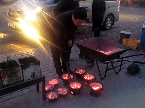
Hot Coals

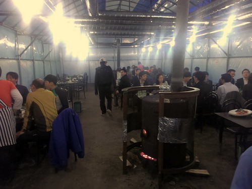
That was pretty cool. Some of our teammates have been talking about this place for a while now, so I suggested that we come here for dinner. Yes, the food was good (and prices cheap), but the more interesting thing about this place is the venue itself, which is out in the middle of nowhere and requires a bit of a drive out of Seoul (212-5 Sangjeok-dong, 31-723-9938).

Outdoor Korean BBQ

See, one can choose to eat outdoors on the gravel with light bulbs dangling overhead. It was a bit cold tonight so they enclosed the dining area with plastic sheets to keep the heat in, but I can imagine that this would be even more fun during warmer days when presumably everything is just out in the open air. The charcoal kept us warm at least...as well as the copious amounts of soju.

Korean BBQ

Tony's Pizza on River Valley in Singapore

Pizza

I'm a bit torn about this place (397 River Valley Road, 6777-4992). On one hand, I absolutely hate how overpriced it is at S$6.50 (US$5.15) for a slice of cheese pizza that hardly puts a dent in my stomach. And S$4.50 (US$3.50) for a glass of watered-down lemonade? Bah! Every time I come here, I tell myself that I'll never go back.

And yet, I've been back here at least two or three times, in part simply out of sheer convenience, but also since there really isn't anywhere else around here that one can get a New York-style pizza by the slice, complete with oregano and garlic powder at each table. Admittedly it does smell pretty good in there when you walk in. (Where is the parmesan shaker, BTW??)

Either way, I keep cringing each time the cashier tells me how much I owe them. Yes, I know that it's not fair to compare to prices in New York when we are halfway around the world, but it still irks me. Surprisingly, I've seen multiple people paying at least S$42 (US$33) for an 18" pie there...and lots of bike deliveries too. Maybe next time I'll stick to their buffalo wings instead.

Clonfert Cathedral, County Galway

For daily updates on Ireland's wonderful heritage please follow us on Facebook, Twitter, Google+ and Instagram

Clonfert Cathedral in County Galway is probably best known for its amazing doorway, the finest example of Romanesque architecture in Ireland. The Romanesque style of architecture was influenced by classical Roman and Byzantine architecture, and generally dates to the early medieval period, some time between the 8th - 11th Centuries AD across the continent. It appears a little later in Ireland, and seems to coincide with large scale reforms of the Irish church in the twelfth century. The Irish builders incorporated their own styles with Romanesque to create a hybrid of the two, which is known as Hiberno-Romanesque architecture. 

A close-up of the carved heads

The doorway at Clonfert is in six ‘orders’ and has inclined jambs. Above the doorway, a steep triangular pediment is covered with Romanesque decoration showing animal heads, foliage, zig-zags, chevrons, but most striking of all are the individually carved human heads.


The wonderfully ornate Romanesque decoration
However striking, the Romanesque doorway was a late addition onto a church that was already famous in Ireland. It is referred to in the annals before 1050 as one of the four largest churches in the country (Annals of the Four Masters, Annals of Inishfallen, Chronicon Scotorum). Clonfert is associated with Saint Brendan, he is said to have founded a monastery here in the sixth century. Brendan is known as The Navigator, and is one of the most famous of Ireland’s monastic saints. 

A ninth century book The Voyage of Saint Brendan the Navigator records his legendary journey to ‘The Isle of the Blessed’, a journey that involves sea monsters, strange islands and their inhabitants and that some people even believe to suggest that Brendan was the first European to discover America! There are no remains of Brendan’s monastic site visible at Clonfert, though a gravestone in the churchyard marks the spot where he is allegedly buried.


15th Century sculpture, note the mermaid at the base
As you pass through the doorway into the cathedral you can notice that the innermost part of the doorway is a later medieval (around the fifteenth century) addition, carved of grey limestone in contrast to the sandstone of the flamboyant Romanesque door. Much of the fine carvings and archway in the interior are also of fifteenth century date, and see if you can find a charming carving of a mermaid dating to this period too. She is similar to that at nearby Clontuskert.  
Clonfert is certainly worth a visit to see the spectacular Romanesque doorway and the wealth of later fifteenth century sculpture inside. You’ll find it around 15km south-east of Ballinasloe, when you get to Laurencetown it is signposted down a minor road to the east off the R355 (Ballinasloe – Portumna Road). At co-ordinates 53.240651, -8.058621.

You can find more information about Clonfert from their website http://www.clonfertdiocese.ie


The interior of Clonfert


If you have a suggestion for a site I’d love to hear it, please let us know by dropping us a line at info@abartaaudioguides.com or on Facebook, Twitter, Google+ and Instagram where you can keep up with daily pictures and information about Ireland's wonderful heritage sites.If you'd like to support us please consider downloading one of our audioguides from www.abartaaudioguides.com, they are packed with great facts, information, stories and legends from Ireland's iconic sites. They are designed to be fun and informative whether you are visiting the sites or from the comfort of your own home, so if you are looking to escape to the Court of Brian Boru the next time you are doing household chores download one of our guides and let us whisk you off to ancient Ireland!


My Work: Orissa & Chhattisgarth

Photo © Tewfic El-Sawy-All Rights Reserved

Photo © Tewfic El-Sawy-All Rights Reserved

Here are two images made while traveling in Chhattisgarh and the neighboring Orissa. There were made using my first digital camera, the Canon 10D...remember that one?

The first is of an Odissi dancer in Bhubaneswar. Odissi is one of the eight classical dance forms of India. It originates from the state of Orissa, in eastern India. On the basis of archaeological evidence, it's the oldest surviving dance form of India.

The second is of an adivasi in the Bastar region of Chhattisgarh, whom I found amongst the thousands of tribal people who congregated at one of the weekly haats. It's estimated there are 300 haats in Bastar, where villagers come to buy basic necessities, and to socialize.

It's at these haats that the adivasis imbibe copious quantities of toddy, the palm wine ubiquitous in these parts. The fellow was in a pseudo trance along with other members of his group. Despite my efforts, I never found out what the purpose of the trance was.

Here's my gallery The Adivasis of Chhattisragh.

Video: Adventure On Fast Forward

The pace of the video below would best be described as "breakneck." Once it takes off, there is barely time to catch your breath as it speeds through a series of beautiful and adventurous timelapse segments. The title of the video is "Pause #24" but really its adventure in fast forward.

PAUSE #24 from PAUSE on Vimeo.

POV: Children Should Never Go Hungry

Photo © Tewfic El-Sawy -All Rights Reserved

The Zocalo, with its cultural activities, is the very heart of Oaxaca, and is a daily magnet for locals and tourists alike. It also attracts vendors of various trinkets, as well as poor children (all of them indigenous...possibly Zapotecs) who attempt to make a few pesos by selling chewing gum. Approaching the restaurants' tables occupied by tourists, these children sometimes shyly ask for left-overs. In fact, that's what three little girls did one evening. We gladly gave them whatever was on our table, and one of us even asked our waiter for a bag to give them half her pizza.

During a festive Guelguetza dance festival of schoolchildren, I looked beyond the colors, music, laughter and frenetic motion, and at the periphery of the stage, saw a Zapotec boy with arms outstretched in askance for fruits from one of the young dancers.

You see, after each dance the young dancers would reach into baskets of fruits, flowers and vegetables, and toss them to an appreciative audience. The Zapotec boy was in that audience, and wanted fruit. Mind you, not for keepsake as perhaps the families wanted, but to eat. However, I also noticed he never reached into the basket full of apricots just inches from him...no, that would be stealing. He just wanted the young dancer to give him one...and he got a fruit.

Not only was I sobered at this sight, but I also read in these unfortunate children's eyes an uncomprehending acceptance that they would never take part in an organized Guelaguetza dance such as the one they were witnessing. I also sensed that they understood that it was so because they were poor and were racially different. They would never wear the colorful Guelaguetza costumes. All this boy could muster was an old over sized baseball cap, and a dirty shirt.

No child should go hungry and no child should beg for food. Ever.

My post on McCurry's taking a celebrity photography project was criticized on another blog by a handful of readers as being misplaced, rude and judgmental...which puzzled me since I specifically wished him the best of luck with his new project, and described him as a pioneer and an inspiration to many.

The thrust of my post was not about McCurry or his future but to stress the need for all of us to diversify by learning and using multimedia, FCB and Soundslides...and not remain stale and repetitive. In fact, here's a quote from the post which encapsulates my point of view:
"McCurry is one of the pioneers of travel photography and is an inspiration to many who follow his style....and to read of this new project is an uncomfortable reminder that things are changing in this industry, and that photographers (whether involved in travel, documentary and editorial) need to be sharp, varied and inventive."
So to these half dozen readers I make no apologies nor do I need to rethink/reword a single syllable of my post. Not only did you misunderstand my post's intention, but dismissed it as a rant (my POVs always are), denigrated my photography (I do that all the time so get in line and get a number), sneered at my having been a banker in my previous life (many people have more than one career, so I don't understand your point unless, God forbid, you're envious) and so on. Heck, even my country of birth was mentioned...what does it have to do with my blog posts unless it's a jingoistic innuendo? Yes, the mind boggles.

Let me also say that one of my readers also misunderstood what I meant, and had the courtesy of emailing me expressing his viewpoint, and asking for clarification. I responded, and we ended up agreeing on certain issues and disagreeing on others.

As for my pontificating, as a couple have described my post(s), that's exactly what I do here on this blog. That's what this blog is about and will continue to be. You don't have to pay any attention to it. If it aggravates you, just improve your life and remove it from your reading list, because the mission of this blog is to pontificate and to support emerging talent...period. If you don't like it, just don't read my "rants" and "pontifications"...it's really that easy. I'm only a banker-turned-photographer after all...remember?

However, I'm so enamored by the term that I will soon change the sub title of this blog to include it...perhaps like acerbic pontification...or acerbic soap boxing...thank you for the unintended suggestion!!

New Note: I have to thank all of those who emailed me expressing their support and sharing their unbridled puzzlement at the criticisms, and to those new friends who, as a consequence of all this, have now joined my newsletter mailing list! No new post today...i want to keep this one up for a while.
Looking for a little escape at the start of the week? Then look no further than this great travelogue style video that follows three traveler as they ride from Jaipur, India to Khardung La, the highest road in the world at 5369 meters (17,582 ft). It is a colorful, chaotic journey that looks like it would be quite an adventure.

The exposed chamber of one of the tombs, with the larger cairn topped by an Ordnance Survey point in the background

On Saturday (15th March 2014) we visited Seahan, another of the megalithic tombs of the Dublin and Wicklow Mountains. At Seahan [sometimes spelled as Seehan] you can find the remains of two large stone cairns. They probably date to the Neolithic period, around 5,000 years old, a time when people first began to clear the ancient forests to create fields for farming. They are thought to be the remains of passage tombs, a type of burial monument that appears as a round mound of stones or earth, ringed by large stones set on their edges to form a kerb. Parallel lines of upright stones formed a passageway leading to a chamber which usually contained the remains the dead. 

One of the cairns on Seahan has a very clear kerb of stones surrounding it, but it has been disturbed, possibly in antiquity. It is situated adjacent to a larger cairn that has an ordnance survey point added to its summit. Its possible that some of the stones of the exposed tomb were used in the construction of this large cairn. Archaeologist Christiaan Corlett suggests that perhaps this raises some interesting questions about the relationship of the two tombs – perhaps the people constructing the larger cairn deliberately ‘slighted’ the older tomb to construct a new larger cairn. Perhaps as a way of symbolising their ascendancy over the people who are interred within the smaller tomb and their descendants who built it.
The Ordnance Survey point that has been added to the top of the larger cairn on Seahan.
The cairns on top of Seefinghan (left) and Seefin (right) visible from the tombs of Seahan
Seahan appears to be part of an extended series or cemetery of passage tombs that cover a number of peaks in the area. From Seahan you can clearly see the cairns on top of Seefingan and Seefin. Building these tombs so high in the Dublin and Wicklow mountains must have been an incredibly difficult undertaking in the Neolithic period even though there is an abundant supply of stone on top of the hills. The peaks of these hills are all around 650m – 750m above sea level, so why would they have constructed these elaborate and large stone tombs up here? 

Expansive views over Dublin from the summit of Seahan
We can never say with certainty, but perhaps like a lot of cultures around the world, they believed that to be buried in these high places was to be closer to their gods. Personally though, I think that it was a statement of ownership over the landscape. From this high vantage point the whole of South County Dublin and Wicklow is visible. Green fields, rivers, lakes. Perhaps they believed that any newcomers to this fertile territory would see the very visible tombs in the distance and know that the people living here have done so for millennia. Or maybe they believed that by placing their ancestors far above the low lying lands of the living, the shades of their forebears could watch over them from their tombs. For those interested in prehistoric archaeology, or those who love a bit of hillwalking, or those who just want to see some of the finest views in Ireland, Seahan is a real must-see. 

The Famine Cross, take the road to the left of this monument.
I strongly recommend you use OSI Discovery Series Mapping Numbers 50 and 56 to help you find the tomb easily. To get there exit the M50 at Junction 12 Firhouse. Travel on the R113 towards Oldbawn. Take the left turn for the R114 signed for Bohernabreena. Continue straight on this road, staying right at the slight fork at Bohernabreena. Drive past the golf club on your left and take the road to the left of a famine cross you will see on the left hand side of the road. Continue on this road for about 5 minutes. On a clear day you will see Seahan on top of the mountain to your left and Seefin and Seefingan ahead. Seahan is separated from Seefinghan and Seefin by the Army Rifle Range, if you see signs for that you have gone too far. There is a parking area below Seehan in front of large boulders. Park here and walk along the path. Take the first left on this path - this will lead you up to the summit of Seehan. We had great weather for our visit, but I wouldn’t recommend the trip in poor conditions. It was about a 25–30min fairly easy stroll up the Mountain to the site, but good boots are recommended. Above all though, please do be aware of the Army Rifle Range and respect their warning signs! 


If you'd like to support us please check out our acclaimed series of audioguides to Ireland’s heritage sites, they are packed with original music and sound effects and a really fun and immersive way of exploring Ireland’s past. They are available from www.abartaheritage.ie.
If you’d like to receive daily updates and images of great heritage sites then please consider following us on Facebook, Twitter and Google+.


Some Sources and Recommended Reading:

Corlett, C. 2012. The Megalithic Tombs of South Dublin, Archaeology Ireland Heritage Guide No.57. (Wordwell, Ireland)
Cooney, G. 2000. Landscapes of Neolithic Ireland (Routledge, London)
Waddell, J. 2000. The Prehistoric Archaeology of Ireland (Wordwell, Ireland)


All photographs and text © Neil Jackman / www.abartaheritage.ie
The stunning landscape of the Dublin Mountains, like a different world and less than 30mins from Dublin!