The Clifford Pier at the Fullerton Bay Hotel

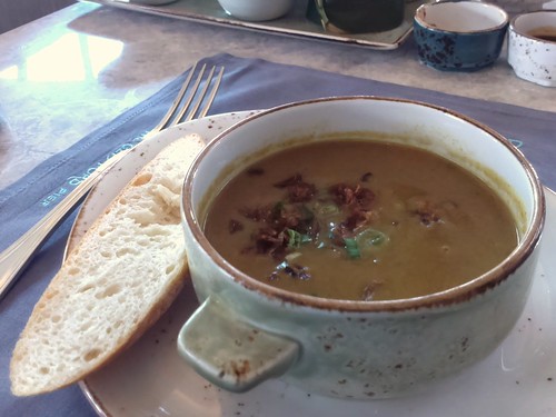
Kambing Soup

When I read about this place in the Sunday Times, I had mixed feelings. On one hand, I was sad that One on the Bund had departed; it was probably one of my favorite places in Singapore. On the other hand, the restaurant that went up in its place served kambing soup, one of my favorite local dishes next to bak kut teh and bak chor mee. I was so excited to see how they would do it here that I knew I had to come here for lunch this week (80 Collyer Quay, 6597-5266).

The interesting - and perhaps disappointing - thing was that the menu was a mix of things like burgers and local food like laksa and chicken rice, seemingly being nothing more than a typical ground floor restaurant of a local hotel by trying to appeal to the widest audience possible. But this was definitely much more upscale than most other hotels, as evidenced by the new airy decor and furniture, which surely didn't come cheap.

And yes, this decor was built into the price, with that kambing soup above coming in at S$15 (US$12), or at least three or four times more than what one would pay at a hawker center. Sure, the food was of high quality, but Brothpot Mutton is good enough for me in that department. I think the only time I'll come back here is for a business meal, particularly if someone has come in from out of town. And at that point, I might try one of their lobster rolls.

Grianan Ailech, County Donegal

The Grianán of Ailech is one of the most iconic sites of North-West Ireland. It is located in County Donegal, roughly about 8 km north-west of the city of Derry. The entire site itself is enormous, with large outer earthworks circling Greenan Mountain. This huge enclosed space is probably the remains of a Late Bronze Age or Iron Age hillfort. It was regarded as a ‘Class 2 Hillfort’ by Barry Raftery in his excellent book Pagan Celtic Ireland.  He described it as having

‘four concentric enclosures, the innermost...being a small, ringfort-like structure...likely to be a late addition which probably had nothing to do with the prehistoric hillfort’. 


It is this inner stone ringfort or cashel that is most commonly thought of today as being the Grianán of Ailech. The site was said to have been the residence of the powerful Kings of Ailech, the Uí Néill dynasty. In the first few centuries AD the Uí Néill controlled vast swathes of territory in the northern half of the island of Ireland. However as their power began to wane they became locked in a bitter dynastic war with the Kings of Munster. The Grianán was recorded in the Annals as being destroyed in AD 676, and then more thoroughly in 1101. The destruction was recorded in detail in the pages of the Annals of the Four Masters. It recounts that the King of Munster, Muircheartach Ua Briain (grandson of the famous Brian Boru), led his army deep into the territory of the Uí Néill’s in Inishowen and burned many churches and forts. He demolished the famous Grianán of Ailech in retaliation for the burning of the Munster capital Ceann-coradh (Kincora in County Clare) which had been burned by the allies of the Uí Néill some time before. The Munster King Muircheartach had each man in his army carry away a stone from the destroyed fort, forever denying it to the Uí Néills.


The interior of the fort


A short video to show the interior of the stone fort

The site was heavily reconstructed in the nineteenth century, so we will never know its original form. Despite this, it is still one of the most rewarding sites to visit in Ireland. 

 
The name Grianán roughly translates to Palace of the Sun, unfortunately the day we visited was heavily overcast with showers, though even the low cloud couldn’t obscure the quite magnificent views over the Inishowen Peninsula, Lough Swilly, and Lough Foyle. The site absolutely dominates the skyline from a great distance. Entering the central cashel you pass through the massively thick drystone walls that tower above you. Stone steps lead to the top of the walls allowing you to look upon the stunning landscape that surrounds you (I have included some landscape pictures at the end of this article). It is a fantastic experience and one that I highly recommend if you are travelling to the North-West of Ireland. Just outside of the fort you can also find a cairn of uncertain date and a small holy well.

The Holy Well just below Grianan Ailech
The site is under the auspices of the Office of Public Works, however apart from a good road and a large carpark there are no other facilities at the site. The Grianán of Ailech is well signposted from the N13 between Derry and Letterkenny, it is located roughly around 8km north-west of Derry.

You’ll find it at Latitude: 55.02379103 Longitude: -7.42761612


I hope you enjoy our blog posts. If you would like to see daily updates with pictures and information on Irish heritage sites, archaeology and history please consider following us on Facebook, Google+ or Twitter.

If you would like to support us please download an audioguide from www.abartaaudioguides.com. There are currently fourteen guides available with four free of charge and the rest costing just €1.99. They are full of original music and sound effects and are a fun and immersive way of hearing the story of some of Ireland’s most iconic heritage sites and places. They are as enjoyable at the site as they are from the comfort of your favourite armchair at home, why not try our guide to Viking and Medieval Dublin to hear the story of a city?


 Some images of the landscape surrounding the Grianán Ailech
The Grianan Ailech dominates the landscape for miles around


Clonmacnoise, County Offaly

If you’d like to receive daily updates about great heritage sites 

please consider following us on FacebookTwitter, Google+ and Instagram.
Located on the banks of the River Shannon in County Offaly, Clonmacnoise is one of Ireland’s most iconic historical sites. The monastery was originally founded by Saint Ciarán in the middle of the sixth century. Unlike many of the other early Irish saints who often came from privileged families, Ciarán was the son of a carpenter. Despite his humble origins, Ciarán soon gained a reputation for his intelligence and holiness. After completing his education, Ciarán became the founder of a small monastery on Hare Island in Lough Ree, before choosing the site of Clonmacnoise to establish another monastery. 

His choice of location at Clonmacnoise was incredibly shrewd. Though today it seems like a peaceful and somewhat isolated place, in the early medieval period Clonmacnoise was at the crossroads of the two major routeways of Ireland: the mighty River Shannon and the Slí Mór (meaning The Great Way) the roadway that traversed the country from east – west over the glacial eskers that offered easy passage over the wetlands and bogs of the midlands. Clonmacnoise was also situated on the borders of two of the great kingdoms of early medieval Ireland, Connacht to the west, and Mide (Meath) to the east, and the site prospered from its close relations to both of the ruling dynasties. 

Clonmacnoise from the River Shannon. The Shannon was a major routeway of  early medieval Ireland, and this view from the river would have been one familiar to the majority of pilgrims who visited the site. You can experience a river trip to Clonmacnoise by boat from Athlone. See http://www.vikingtoursireland.ie for more information.
The Cross of the Scriptures (a replica, the real one is in the visitor centre)
The earliest churches at Clonmacnoise would have initially been wooden constructions, known at the time as a dairtheach (Oak House), but as Clonmacnoise grew in power and prestige these were gradually replaced with grander buildings made from stone, often founded by Kings and nobles. In AD 909 King Flann commissioned the construction of the Cathedral and the beautiful high cross known as the Cross of the Scriptures. The cross now on display in the excellent visitor centre, bears an inscription marking the event. Not to be outdone, over the centuries more ruling dynasties like the O’Melaghlins (kings of Meath) commissioned churches at Clonmacnoise. The monastery grew wealthy as rulers and nobles clamoured to be buried within the same hallowed ground as Saint Ciarán, as it was believed that the saint would ensure entry into Heaven.


The Round Tower of Clonmacnoise known as O'Rourke's Tower, named in honour of its founder.
At its height the monastery was surrounded by a large bustling settlement, with markets, craftsmen, labourers and farm-workers. It would have been surrounded by one of early medieval Ireland's largest populations, outside of the Viking cities of Dublin, Waterford, Limerick and Cork. The growing wealth and reputation did not go unnoticed, and Clonmacnoise was raided a number of times through its history, mostly by warriors from rival Irish kingdoms like Munster, and in AD 842 and 845 by the Vikings. 


As the fortunes of the once mighty kingdoms of Meath and Connacht waned following the Norman invasions, Clonmacnoise too gradually declined over the centuries. The Normans left their mark on the site by constructing Clonmacnoise Castle to ensure they controlled the strategically important crossing point of the Shannon. Despite Clonmacnoise having a brief period of resurgence in the early seventeenth century, by the mid-1600s the site had been largely abandoned. Its isolation has left us with a wonderfully atmospheric site that is a fantastic place to explore. 

The round tower of Temple Finghin with the Shannon in the background
One of the cross-slabs on display in the Visitor Centre
Today Clonmacnoise is under the auspices of The Office of Public Works, and a visit to the site should be on everyone’s bucket list. Inside the visitor centre you can see the original high crosses, and a superb collection of graveslabs that give fascinating insights into life and death at Clonmacnoise. There are over 700 examples of cross slabs known to have associations with Clonmacnoise. The purpose of these slabs is thought to mark the burial place of a monk or holy man or person of prestige. The earliest slabs date to the seventh century and generally feature a simple cross design. Over the centuries, their designs develop and become more elaborate. The inscriptions on the slabs generally include the words 'poor', 'servant of', or 'tonsured one' which leads scholars to believe that the cross slabs generally mark the burial place of monks or other church figures. Other slabs feature the names of Kings and on one instance an inscription referred to ‘the most learned doctor’ so we can deduce that the slabs were also used to mark those of rank and prestige within medieval society. This cross-slab pictured here asks for: 
'A Prayer for Tuathal the Craftsman'.


When you have finished exploring the main site, don't forget to follow the Pilgrim's Path for approximately 400m or so to The Nun's Church. The Annals record that the Nun's Church was completed for Derbforgaill in 1167. It is located in a field to the east of the main monastic complex and is one of the finest examples of Hiberno-Romanesque architecture in Ireland. Serpents, plants, and highly stylised animal heads are all represented on the arches of the west portal and chancel arch. 
The beautiful Romanesque architecture of The Nun's Church.

For information about entry fees and opening times to the visitor centre please visit here

If enjoy my blog and you'd like to support us, please try our acclaimed series of audioguides to Ireland’s heritage sites, they are packed with original music and sound effects and a really fun and immersive way of exploring Ireland’s past. They are available from abartaheritage.ie and a number are absolutely free to download.

If you’d like to receive daily updates about great heritage sites then please consider following us on Facebook, Twitter and Google+.

All content & photographs © Neil Jackman /abartaheritage.ie

The beautiful 15th century north doorway into the Cathedral


TAKING THE FERRY TO CEYLON (BEFORE IT WAS SRI LANKA)


The first time I went to Sri Lanka it was 1970. It was about the most faraway, exotic place I had planned to go to on my drive across Asia, a place I had always fantasized about. After months in India, anything would be a breeze so I had no trepidation whatsoever when I set out for Rameswaram from Cochin in Kerala. The road wasn't great and I can remember that I never saw a plate or eating utensils on the whole drive south; all food was served on banana leaves. I guess its kind of a truism to say that the food got spicier and spicier the further south you ventured, but even a truism is based on something. I love spicy food and it didn't bother me at all. South Indian cooking is very different from North Indian cooking and I dove in wholeheartedly. The roads were definitely not as good as the food. I remember once there was a big boulder in the middle of the narrow road but I realized immediately it was a trap set by decoits (bandits). Fortunately they were lethargic and lame and we somehow managed to avoid being killed or even interacting with them.

I can't remember who I was with at this point. I used to meet people who liked the convenience of a nice new VW van. They got transportation and paid the gas and other car-related costs. I was thoroughly broke at this point, having run out of whatever money I had in Goa. All I remember about the Cochin to Sri Lanka crew is that everyone got tattoos when we got to Jaffna except me (who thought a- it was probably unsanitary, and b- it would nix any chance I had of being buried in a Jewish cemetery if I ever changed my mind about the religion thing). But I'm jumping ahead of the story.

After outsmarting the decoits and arriving in Rameswaram, I don't recall much about the town. Supposedly it's a big pilgrimage scene but I don't recall anything but it being a small, grimy port town with a ferry that crossed the Palk Strait to Talaimannar at the tip of a small peninsula that jutted out of northwestern Ceylon (which is what Sri Lanka was called then). The problem was that the ferry was too big for the port at Rameswaram and one had to be rowed out to the ship on a small boat. My recollection-- colored by unabated terror even after 3 dozen years-- can't possibly be precise. They put a wooden plank between two small boats and had me drive my van (which was my entire universe at the time-- and not insured) onto it, so they could row it out to the ship which had a crane to lift it aboard. It sounds beyond belief-- even to me! But what I do remember in vivid detail is being on the ferry with my van hanging in mid-air, courtesy of the crane, and a representative of the Indian (or Ceylonese) maritime workers union approaching me for some baksheesh. It was a smart time to ask because I was thoroughly terrified and in no position to dicker, something I had become quite adept at in the preceding year. I think he wanted $6 or 7 and, although that put a serious dent in my budget, I was happy to give it to him and get my van back safely. The Ceylonese side had a pier where the ferry actually docked.

I forgot to mention that I was smuggling. I had found that the Ceylonese wanted cheap saris from India and the Indians wanted large tins of coconut oil from Ceylon. No one ever checked the van for anything ever. I made a lot more money later in the year smuggling alcohol from Pondicherry, the old French (Christian) colony just south of what was then called Madras (now Chennai), to Madras' YMCA where Muslim gentlemen put out by Madras' dry laws were eagerly waiting. Like I said, no one ever checked the van and I scraped up enough to live for a month or two at a time.

There were literally no tourists traveling this way; I mean I never met one driving around southern India the whole time. So we had no real advise about what to do or where to go. I suppose the normal thing would have been to drive south to Colombo. So, of course, I drove north to Jaffna, the Tamil city. I remember it being a big, busy exotic city without a lot of charm, but with delicious food. I remember eating omelets cooked in coconut oil; HEAVEN! The taste stayed with me for decades and eventually brought me back to Ceylon (by then Sri Lanka) for another visit. Everything was cooked in coconut oil. I bet you didn't know that coconut oil is very healthy, did you? We were all brainwashed into thinking it was horribly fattening and disease-causing. But that's completely false.

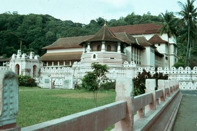
My more recent memories of Sri Lanka are going to be a lot more vivid and useful and I'll try to get them down this week. I don't remember much about the first trip beyond the tastes and smells... and the beautiful tropical beaches. It was a real chill-out time for me after the hustle and bustle of all-consuming India-- kind of like a vacation. I made a point of circumnavigating the island-- something that is impossible now because of the guerilla war and I can remember a few towns that I really liked standing out, Walauttu, Batticaloa, and Trincomalee on the east coast, Hikkaduwa, Hambantota and Galle on the glorious south coast, Nuwara Eliya, Kandy (home of the sacred Temple of the Tooth; see photo above), and Anuradhapura in the middle. I never stayed at one hotel, just slept in the van or on the beach every single night. I have a recollection of swimming and lounging around the beach during the hot days and then driving into the cooler highlands to sleep at night.
Way back in August I wrote a post about Reza Reza Pakravan and Steven Pawley, two long distance cyclists who were embarking on an epic ride from Nordkapp, Norway to Cape Town, South Africa. Their plan was to cover the 18,000 km (11,184 miles) distance between those two cities in just 100 days. Yesterday they completed that ride and they missed their target goal by just two days.

Reza and Steven faced all kinds of challenges as they rode through 14 different countries on their journey across Europe and Africa. Along the way they faced nasty winds, surprisingly bad weather and unexpected illness. The latter of those challenges was what ultimate prevented them from completing the ride in the expected 100 days. Despite all of the difficulties they had to overcome on their ride, the duo still only missed their scheduled arrival by two days. That is pretty impressive considering the number of miles they had to ride in such a relatively short time.

The video below was shot following their arrival in Cape Town yesterday. Not only did that mark the end of the expedition, Reza and Steven also announced that they had raised £20,000 ($32,375) for Azafady, a nonprofit that is working to build schools in Madagascar.

Congratulations to Reza and Steven on completing their incredible ride. In order to reach Cape Town yesterday, they had to average 176.5 km (110 miles) for 102 days straight. Those are impressive numbers indeed.


Last Friday ExWeb broke the news that a team of French climbers had successfully climbed Annapurna along the very difficult South Face. As we all know, any summit of Annapurna is always an impressive one, but this one was especially so thanks to the heavy snows that have fallen in the Himalaya following Cyclone Phailin making landfall a few weeks back. At the time, we knew very few details of the climb other than that Yannick Graziani and Stephane Benoist were able to top out after spending  a week on the mountain. We were also waiting for news on their successful descent, which still hadn't happened the last time we had an update.

Yesterday, ExWeb reported that Yannick and Stephane actually had to be evacuated from Annapurna after suffering frostbite on the descent. The details still remain scant but it appears that they struggled on the way back down but were able to reach Base Camp. Once there, it was determined that they would need medical attention and the duo were flown back to Kathmandu, where they are reportedly being treated now.

ExWeb speculates that the injuries weren't particularly serious, although it is sometimes difficult to tell with frostbite, particularly early on. Hopefully Yannick and Stephane won't be losing any digits and they'll be back in the mountain soon. Considering how dangerous Annapurna can be, they should feel fortunate they got away with just a little frostbite.

They are due to return to France sometime in the next couple of days.

Monasterboice, County Louth

Monasterboice in County Louth is home to the most spectacular high crosses in Ireland. The name Monasterboice derives from Mainistir Bhuithe (Buithe’s Monastery), as a monastery was thought to have been founded here by St. Buithe in the 6th Century. Over time this monastery flourished and grew in both size and prominence. Archaeologists studying aerial photography of the area, identified three concentric enclosures surrounding the core of the site, with the outer enclosure having a diameter of at least 600m (1968ft) enclosing a massive 24 hectares. Today all that is visible is the very heart of the monastery, with a fine round tower and three high crosses, one of which is arguably the finest high cross in Ireland.

The Round Tower
Monasterboice is still used as a graveyard today, and there are good paths that lead the visitor through the site. As well as the early medieval high crosses and round tower, you can also see the remains of two small stone churches. These probably date to the late medieval period, and probably date to around the fifteenth century. Within one of the churches you can see a small bullaun stone. This stone with a circular hollow may have been used as a rudimentary holy water font during the early days of the monastery, or perhaps used as a large version of a mortar-and-pestle, maybe to grind herbs, ore for metallurgy, or pigments for manuscript illustration. 

The round tower is a fine example, and stands at 28m (approximately 92ft) high. The iconic Irish Round Towers are thought to have been primarily constructed as bell towers as they are known as ‘cloigh teach’ in Irish Gaelic which translates to ‘bell house’. They would have also been visible from miles around, and as such they would have acted like a signpost to weary pilgrims on the route to Monasterboice. The round tower here was said to have housed the monasteries library and other treasures, unfortunately though it is recorded as being burned in 1097.
B&W Image of one of the churches with the tall West Cross on the right
The path through the graveyard to the Round Tower

South Cross (Muiredach’s Cross)

The Eastern Face of the South Cross
The incredible South Cross is arguably the finest example of a high cross in Ireland. It probably dates to the early tenth century, as it is very similar to the West Cross at Clonmacnoise that was dated to c.904–916 AD. Like the Clonmacnoise example, the South Cross at Monasterboice also bears an inscription, asking for ‘a prayer for Muiredach’. It seems likely that this refers to Muiredach who died in 924 AD. He was the abbot of Monasterboice, and the vice-abbot of Armagh. He was also the chief steward of the powerful Southern Uí Néill dynasty, making him an incredibly important and influential figure in both religious and secular Ireland.

Depiction of The Last Judgement
The Western Face of the South Cross
My photographs cannot do the South Cross justice. It simply is one of the most important and visually stunning examples of early medieval sculpture in the world. The centrepiece of the crosshead on the eastern side is an amazing depiction of the Last Judgement. The largest figure in the centre is Christ with a phoenix representing the resurrection or perhaps the Holy Spirit, above him. Directly below you can see souls being weighed. To Jesus's right hand side (the left of the image) you can see the souls that have been saved, and nearest to Jesus you can see David playing his lyre. To the left hand side of Christ (on the right of the image) you can see the damned, the poor souls being driven into hell by a demon baring a trident.


The rest of the  cross is taken up with biblical depictions. For example in this image you can see Moses standing with a staff and drawing water forth from the rock. The crowd of people are the thirsty Israelites. The image is a visual representation of the story in Numbers 20:7–13. 


Moses (standing with staff) draws water from the rock
On the south facing side of the cross you can see this image of a snake eating its own tail while coiling around three human heads. Originally I thought that it could be a reference to the snake in the Garden of Eden, or perhaps some sort of warning of serpents dragging sinners to eternal damnation (to be fair the heads don’t look cheerful, and the poor chap in the middle looks like he was caught with a mouthful of crisps), however I was wrong. Thanks to the author of the excellent blog on Christianity in Early Medieval Ireland http://voxhiberionacum.wordpress.com I now know that the snake eating its own tail represents eternity and eternal life, and the heads are being lifted up towards God rather than plunging down into hell. It’s from John 3:14-15:
“Just as Moses lifted up the snake in the wilderness, so the Son of Man must be lifted up, that everyone who believes may have eternal life in him.”
It’s a representation that can be found at a number of 9–10th century Irish high crosses, like the West Cross at Clonmacnoise for example. 
Depiction of Adam and Eve on the left (note the serpent coiled around the tree) and Cain murdering Abel on the right
Here's a guide to some of the imagery depicted on the eastern face of the cross:

The West Cross 

The Eastern Face of the West Cross
The Western Face of the West Cross

The West Cross is the tallest High Cross in Ireland, standing at a massive 6.5m tall. Thanks to its size, it also has the largest number of figure sculpture panels of any High Cross. Like the South Cross these are also beautifully carved with depictions representing biblical stories from both the Old and New Testaments. You can see a great guide to the depictions on the National Museum of Ireland’s website here
Close up of the Western Face of the West Cross


The North Cross


The North Cross
You can find the North Cross within a small fenced area at the very northern boundary of the site, (as you first enter the site turn right and follow the path keeping the wall on your right hand side). It is much plainer than the South and West Crosses, though it is still worth a look as it has some lovely carvings. Next to it you can see an interesting [and rare] sundial, that would have marked the passing of time for the monks of Monasterboice indicating the canonical hours of 9am, 12pm and 3pm. In this small fenced area you can also see some other architectural fragments from the site. 
The Sundial


We took a trip to Monasterboice on a beautiful crisp morning on the 11th January 2014 and found it to be a wonderfully rewarding place to visit. The site is well signposted off the M1, around 8km north-west of Drogheda in County Louth. After your visit I recommend a short 10min drive to Mellifont Abbey, another beautiful site situated very close by. While you’re in the area if you enjoyed the stunning early medieval high crosses why not take a short spin down to Kells in County Meath, where you can find more fantastic examples of early medieval high crosses. We have a FREE audioguide to Kells full of facts, stories, legends and history. To download your free MP3 please visit Abarta Heritage or to download a free audio-visual app for Apple or Android visit here https://www.guidigo.com/A6QzbS7ImVo

This is our first blogpost of 2014. We have so many more of Ireland’s fantastic heritage sites to share with you that I hope to up our output to one or two blogposts a week if possible. I’m planning on tweaking the blog a little so if you have any suggestions of key information you’d like me to include please do drop me a line to info@abartaaudioguides.com or feel free to leave a comment below. I’d really value your input.


As a new addition here is a table with some key information:


If you’d like to keep up with daily images and information about Ireland’s fantastic heritage sites please consider following Neil’s company Abarta Audioguides on FacebookTwitterInstagram or Google+.

If you’d like to support us please consider downloading an audioguide from abartaheritage.ie: they are packed with great facts, information, stories and legends from Ireland’s iconic sites. They are designed to be fun and informative whether you are visiting the sites or from the comfort of your own home, so if you are looking to escape to the Court of Brian Boru the next time you are doing household chores, download one of our guides and let Abarta whisk you off to ancient Ireland!

All images © Neil Jackman/Abarta Heritage


Some Sources and Recommended Reading:

Edwards, N. 2002. The Archaeology of Early Medieval Ireland. (Routledge, London)
Hamlin, A. and Hughes, K. 1997. The Modern Traveller to the Early Irish Church. (Four Courts Press, Dublin)
Ó Carragáin, T. 2010. Churches in Early Medieval Ireland. (Yale, Singapore).

Ó Cróinín, D. (ed) 2005. A New History of Ireland, Prehistoric and Early Ireland (Oxford University Press, New York).
Donadea Castle and Forest Park, County Kildare

Peig enjoying her walk at Donadea
Donadea Forest Park now encompasses almost 250 hectares. The demesne was established by the Anglo-Normans as a Manor, and the demesne passed to the Aylmer family in 1558. In 1624 Gerald Aylmer completed the construction of a Tower House, which is now the oldest part of the existing structure, as most of the visible remains we can see now date to the early nineteenth century. 
Donadea House
Lime Tree Avenue
The Aylmer's became embroiled in the Catholic Confederacy uprising in the middle of the seventeenth century, and in 1642 the powerful James Butler, Earl of Ormonde, despite being the brother-in-law of Aylmer, successfully laid siege to Donadea Castle and burned it to the ground. The house was rebuilt by 1772, and in the early nineteenth century, Gerald George Aylmer began an extensive programme of renovation, reconstruction and modernization on the estate. He had the house remodelled in the fashionable Gothic style of the time, he had large walls constructed to enclose the demesne, with a grand new carriageway (today called Lime Tree Avenue) to lead into the estate.

You can discover some of these features (including a great example of an ice house), on the grounds of the estate. 
The ancient routeway of Ireland, the Slí Mhór (The Great Way), that traversed Ireland from East to West, passes through Donadea. 
Alongside this highway of ancient Ireland, a church was founded in the early medieval period. Very little remains above ground today of the church, but a new church named St. Peter's was constructed as part of the large programme of works in the early nineteenth century.


St. Peter's Church at Donadea

A lake was also created as a landscape feature and to provide work during the Great Famine. Today it's one of the busier areas of the park, with families feeding the numerous ducks and enjoying the tranquil surroundings. Close by to the lake, you can find a poignant memorial to those who lost their lives in the Twin Towers at 9/11.


The Donadea Forest Park is under the management of Coillte, and is a great place to enjoy a walk. There is an entrance fee of €5 per car, and if you plan on making a few visits I strongly recommend purchasing a Coillte Outdoors Card for €35 that allows you to access a number of forest parks around the country for a year, you can find more information on these cards here.

For more information on Donadea, see here. 

I hope you enjoy this blog, we're trying to cover as many sites as we can across Ireland. If anyone has any suggestions about sites you'd like us to cover please do leave us a comment. If you enjoy information and images of Irish heritage sites then do follow us on Facebook, Twitter and Google+

If you'd like to support us then please consider downloading an audioguide to one of Ireland's wonderful heritage sites. They are packed with original music and sound effects and are a great way of experiencing the story of Ireland. They only cost €1.99 and are fun whether you are at the site, or listening from the comfort of your own home. Our latest guide is to Viking and Medieval Dublin, visit us at www.abartaaudioguides.com for free previews. 


All photographs © Neil Jackman / abartaaudioguides.com

Antarctica 2013: More Expeditions Hit The Ice As Storms Continue To Cause Problems

After the long holiday weekend I'm back with some updates from the Antarctic. While I was away there have been some developments at the bottom of the world as more teams have hit the ice at last. But the weather window to deliver them to the frozen continent was a narrow one, as storms continue to cause problems across the region. So much so that many of the newcomers are finding it difficult to make much progress.

Perhaps the biggest news from this past weekend was the start of Richard Parks' attempt to set a new speed record for skiing from Hercules Inlet to the South Pole. Richard hopes to complete that distance in just 23 days, which would be an impressive feat indeed. But bad weather and poor surface conditions caused Parks to get off to a slower start than he intended and it soon became clear that he was already losing ground, even in the early stages of the expedition. Yesterday, Richard made the decision to return to Hercules and wait out the weather for a bit longer. He hopes to get a better window for his attempt soon so that he can make a serious run at the record. In the meantime, the folks at ALE will provide him with plenty of food and water while he waits so that he'll have his full supply for when he sets out for the South Pole once again.

16-year old Lewis Clarke has begun his South Pole attempt as well. He and his guide Carl Alvey were delivered to Hercules over the weekend and officially got underway yesterday. Lewis is attempting to become the youngest person to ever ski the full distance along the traditional route. He hopes to spend this first week on the ice finding his rhythm and getting into a groove. The early days of any Antarctic expedition are always tough and much of the time is spent skiing up hill, but once those early hurdles ae crossed, teams usually settle into a routine and hit their stride. Hopefully that will hold true for Lewis as well.

Daniel Burton, who is attempting to ride his bike to the South Pole, officially began his journey yesterday although he only covered a minimal distance. He'll have his first full day on the bike today as he begins the long, slow, painful slog up to the Antarctic Plateau as well. Pulling a heavy sled up hill can be challenging enough, but doing so on a bike is even more difficult. Throw in the fact that the storms have been dropping plenty of fresh powder on the starting point, and Dan has some real challenges ahead. If he is successful, he could become the first person to ride the full distance to the South Pole. I say "could" because there are a couple of other riders making that attempt as well. We'll just have to sit and wait to see who will be the first to complete the journey.

Chris and Marty Fagan have launched their South Pole expedition as well. The husband and wife team are also skiing from Hercules Inlet to the South Pole, although they aren't attempting any kind of "first" nor are they seeking records. Instead these two endurance athletes are simply on the continent to add to their resumes and enjoy the adventure. They officially got underway today and seem to be in great spirits now that their journey has begun. Tomorrow will mark their first full day out on the ice.

Parker Liautaud's Willis Resilience Expedition gets underway today from Hercules Inlet as well. A veteran polar explorer at the age of just 19, Parker and his guide Doug Stoup will be skiing to the South Pole while also collecting samples of ice that can be used to explore the impact of climate change on the Antarctic. They have a support vehicle riding along with them that will also help take a series of scientific readings about the weather and climate on the continent as well.

Finally, Antony Jinman has launched his South Pole expedition as well after arriving at Hercules yesterday. He will now make a solo and unsupported journey by skis to 90ºS while also interacting with students from around the globe while he's traveling. Antony's goal is to teach young people about climate change and the impact it is having on the Poles, which will eventually have an effect on other parts of the world as well.

That's all for today. There are plenty of other things to report now that so many expeditions have started, but I'll save some for the next few days. It looks like it is going to be an exciting season in the Antarctic with lots of activity to cover.