Rest of Everest: Tibet 2007
As a big fan of video podcast The Rest of Everest I mentioned several weeks ago, before I left for Africa, that Jon was heading back to Tibet as well. Had I not gone on hiatus for two weeks myself, I would have reported regularly on the Tibet 2007 updates, blog posts, and podcasts.
But, it's better late than not at all, right? To follow all of Jon, and his good friend Scott's, adventures head on over to the Tibet 2007 Webpage to find out what they were doing while they were there. The podcasts, as always, are fun and interesting, and the blog posts are a good read as well. It looks like Jon is going to have plenty of material to keep feeding our Everest addiction for some time to come.
Welcome home Jon. I hope your case of jet lag isn't as bad as mine! ;)
Weather Window Closing On Everest!
The great weather that teams have experienced on Everest for the past week or so seems like it's nearing an end. Alan Arnette is reporting that winds have already begun to pick up on the North Side, and that teams have already aborted their summit bids and are turning back due to high winds. In the South, things remain good for now, but conditions can change quickly, so teams that are still on the mountain are making their final push as quickly as possible.
Summits continue however as the LUNGevity Team topped out yesterday and everyone is reported to be back in C2 safe and sound. The boys did report high winds at the summit though. Members of the DCXP Team also successfully summited, but reported quite a bit a snow as they approached the top too. Meanwhile, The Mountain Madness Team is at C3 and still going up, and if everything is going to plan The London Business School Team should be making their final run as well.
Both MountEverest.net and The Adventurist have posted more information on the female climber who was left behind by her team at The Balcony a few days back. It seems she was part of the Democratic Nepal Everest Expedition, and we know her name is Usha. It is clear that had the IMG Team not stopped to help, and Dave Hahn administered dexamethazone, Usha wold have died alone at 27,000 feet. After the "dex" injection, the team assisted her down to C3 where she was turned over to the doctors of the Extreme Everest Team.
I'm still amazed that her team simply abandoned her at The Balcony. I'm suret hat once this story hits the mainstream, you'll hear new outcries about the ethics of climbing. Lets just hope that they don't lose site of the fact that some very brave men and women preformed heroic rescues on both sides of Everest this season, and clearly the climate has been one of cooperation and safety first. We'll have to wait to see how a story like this is handled in the press though. Hopefully they'll get it right.
Riding The Dragon's Back: Rafting The Upper Yangtze River
In 1987, adventurers Richard Bangs and Christian Kallen led an expedition to paddle the Upper Yangtze River, a place that was about as remote and unexplored as anywhere on the planet at that time. Their journey was a challenging one to say the least, as several previous expeditions to the region had failed, sometimes resulting in the death of a member of the team. But the two men managed to complete their excursion and would later go on to write a book entitled Riding the Dragon's Back that recounted their tale as well as that of others who had tried before them.
A few days ago, Richard posted an excerpt from that book on the Huffington Post. The article has the ominous title of "A Death on the Yangtze," and it offers details of a previous expedition that set out to raft the river. This brief portion of the book offers insights into a major river expedition and gives us a glimpse of the challenges that teams faced when paddling the wild and untamed Yangtze at that time.
The members of the team faced any number of obstacles including difficult water conditions, weather that changed on a moments notice, logistical and supply problems and illness. It is the last of those that brings about the death of one of the members of the team who contracted pulmonary edema hundreds of miles away from a hospital and with no means of being evacuated.
The excerpt is an excellent read and offers some lessons for anyone planning a major expedition. But most of all, it'll probably inspire you to want to read the full book and get the entire story of the race to explore a wild river that wouldn't be conquered easily.
The Priory of St. John the Baptist, Newtown, Trim, County Meath.
Situated very close to the Cathedral of St. Peter and Paul in Newtown, Trim, Co. Meath are the remarkable ruins of The Priory and Hospital of St. John the Baptist. This site sits directly alongside the beautiful River Boyne and it is a superb site to explore.
The Priory was founded in the early thirteenth century by Simon de Rochfort for the Order of the Crutched Friars (Fratres Cruciferi). As well as being a monastery and guesthouse for pilgrims, the site also served as a hospital. The Order of the Crutched friars were just one of a number of religious orders that were brought to Ireland by the Normans following their invasion. They also brought the Knights Templar, the Hospitalliers and Trinitarians, as well as strongly supporting the expansion of religious orders like the Augustinians, Benedictines and Cistercians who already had a foothold in Ireland prior to the Norman invasion.
The site was excavated by David Sweetman in 1984, he discovered the remains of a fifteenth century rood-screen that separated the nave from the choir, and a doorway in the gable end of the nave. He also found the remains of a tower leading to a room over the sacristy and part of the original domestic range to the north-east of the choir. Today you can still find the nave and chancel and a striking three-light window in the eastern wall. The large rectangular three-storey tower is 15th century, and was likely to have been domestic quarters.
You can still make out sections of the later 16th century enclosing walls that surround the site, and one small corner turret is still standing today in the western side of the field.
The priory was dissolved during the Reformation in 1541, and was converted to being a private residence.
This site is a wonderful place to explore, especially on a bright sunny day as it stands right on the banks of the River Boyne. The site is free to enter with a number of interpretation panels to help to explain the history of this remarkable site. The site is just a five minute walk from another spectacular site - St. Peter and Paul's Cathedral, Newtown, Trim (we have a blog post here about that site) and forms part of a wonderful River Walk that starts below Trim Castle in Co. Meath, a wonderful blend of natural beauty and history.
I hope you enjoy this blog, we're trying to cover as many sites as we can across Ireland. If anyone has any suggestions about sites you'd like us to cover please do leave us a comment. If you enjoy information and images of Irish heritage sites then do follow us on Facebook, Twitter and Google+ If you'd like to support us then please consider downloading an audioguide to one of Ireland's wonderful heritage sites. They are packed with original music and sound effects and are a great way of experiencing the story of Ireland. They only cost €1.99 and are fun whether you are at the site, or listening from the comfort of your own home. If you enjoy stories of the turbulent medieval period in Ireland try our guide to Viking and Medieval Dublin, visit us at www.abartaaudioguides.com for free previews and to download your free audioguide to the Rock of Dunamase or the free audioguide to the wonderful heritage town of Kells in County Meath
View from the bridge adjacent to the Priory looking back towards Newtown Cathedral |
On The Way: Foundry Photo Workshop
Well, after a few days of intermittent internet service at our hotel in Kadikoy, Istanbul, it seems we're back to full time availability.
The Foundry Photojournalism Workshop has started in full blast, and it's amazing to see so many various nationalities amongst the students. Different languages different styles perhaps, but all connected by a common denominator: photography.
A splendid cast of instructors (some veterans of the workshop, others new), bringing their personal styles into the mix, and surely there'll be awesome projects and results. My class has met a couple of times already (n fact, I must rush to give my second class this morning), and projects range from documenting traditional religious rituals to the local hip-hop scene. So it's bound to be an exciting few days.
The above photograph was made while waiting for our ferry crossing from Eminonu (European side) to Kadikoy.
Mali feels very safe all the time
Conventional wisdom is that Bamako is uber-safe and Dakar is infested with pickpockets... but otherwise pretty safe. First Dakar: you can certainly feel confident about walking down a dark street in the middle of the night without being molested. The people are outgoing and friendly and respectful. The vibe is extremely amiable and for the week I was there I never ran into anyone who had experienced any pickpockets or who had heard of any-- other than in old guide books. That doesn't mean it doesn't exist, but I sure never saw anything to indicate that it does. I should mention, though, that unemployment is high-- like around 60%-- and that on the surface, aside from lottery ticket sellers, it looks like the main job in Dakar is private security guide.
Obviously you don't throw caution to the wind and run around with a fat wallet sticking out of your back pocket. In fact, I've been wearing a money belt under my arm in lieu of a wallet. I guess I would rate Dakar as very safe for tourists of all ages-- except for the mosquitos. You can't avoid them-- not in Senegal and not in Mali. Ex-pats I spoke to in both countries have told me that they can't take the poisons that western medicine prescribes and that most bites don't result in malaria-- or even Dengue Fever-- and that when you get it you rest and eat well for a week and then you're fine. Healthy people don't die from malaria any more than they die from the flu. Personally, I'm still taking the accursed Maladon.
I'm pretty cautious about what I eat and drink-- including in the U.S.-- and I found Dakar and Bamako safe foodwise as well. I pretty much don't eat in dodgy-looking places and stick to bottled water-- including for bushing my teeth. It's hot as hell here and it's important to keep well hydrated. I met a French woman who lives in Bamako 5 years and says she drinks the water here and has never had a problem.
As for the safety factor in Bamako, as "scary" and foreign as it looks, it would be far harder to imagine a crime against a person here than it would be in L.A. or NYC. On the other hand, you could step into an open trench or an uncovered manhole. And for those who define "safety" as breathing air instead of exhaust funes... well, there's a real problem. Someone e-mailed me and asked me if there is any danger from lions or other predators. I think the Malians ate them all. There are a lot of birds and I hear there's a huge herd of elephants between Dogon country and Timbuktu-- and some hippos (which the Malians are wisely quite afraid of)-- but the only wild animals in Bamako are in the zoo. I've walked all over the city, including to really remote areas without paved roads or the blessings of any kind of modernity, and the only vibe is friendly, friendly, friendly. People are unimaginably poor but this is a Moslem country and the level of personal ethics is very high.
I might also add, there are American flags everywhere and people walk around with Obama t-shirts! This has got to be one of the safest cities for tourists I've ever visited anywhere.
The Aroma of an American Pizza Parlor
I haven't been to one of these places in a million years. To be clear, we're not talking about deep dish Chicago-style pizza (even though the crust was pretty darned thick), nor are we talking about thin New York-style pizza (indeed, this shop's thin crust option was downright inedible in my opinion). And despite being physically in California, this wasn't California-style pizza...nor was it any fancy artisan stuff, for that matter.
This was, instead, the kind of pizza that you'd find at suburbs across the US, where pitchers of Bud Light are plentiful and where soccer moms bring kids after a game. It wasn't a chain like Shakey's; this was a local family-owned shop catering to the neighborhood. In some ways, it was a bit like that stuff that I had delivered to my hotel room many years ago (or gasp - that stuff from the cruise ship!), but marginally better, perhaps just due to the aroma circulating while eating in the shop itself.
Yep - that meant having a salad bar available on site to go along with those breadsticks and buffalo wings while watching the game on the overhead TVs. Now, I know that this was all just a lot of nostalgia rather than anything that I would want to eat again (I'd much rather take proper Neapolitan pizza instead), but I haven't had this many ingredients on a pizza in a long time. Something about that sausage went well with those onions, bell peppers, mushrooms, and pepperoni, and it was interesting to get some "local" pizza after having been overseas for so long.
The beautiful work of Jehad Nga, one of my favorite photographers, is on show at the Bonni Benrubi Gallery on the Upper East Side in New York. The exhibition runs from May 13 to June 16, 2010, and is timed to coincide with the New York Photo Festival. Limited edition prints are priced from $2,800-$10,000.
The UK's Daily Telegraph also featured Jehad's Turkana work. I scratch my head in puzzlement that a UK daily would feature news of a photographic event (and images), while our own newspapers have not. Perhaps I've missed it...?
For background on Jehad Nga and the Turkana images, check my earlier post here.
MountEverest.net has posted a report that Sir Edmund Hillary has been hospitalized in New Zealand after falling in a recent visit to Nepal.
The 87 year old climbing legend, the first man to summit Everest (along with Sherpa Tenzing Norgay) if you're tuning in for the first time, was meeting with the SuperSherpas and Miss Elizabeth Hawley while he was in Nepal last weekend. There have been a number of reports that this will be Hillary's last visit to the country, and although he has stopped climbing years ago, his humanitarian efforts, building schools and hospitals, have brought him back on a yearly basis.
Lets all send Sir Edmund our best wishes and hopes for a speedy recovery.
Video: The Polar Bear Whisperer
Churchill, Canada is a small town that has a big reputation for being the place to spot polar bears in the wild. Recently, adventure travel legend Richard Bangs made the journey to that remote village where he met Andy MacPherson, a local guide who has earned himself a reputation as the Polar Bear Whisperer. The video below introduces us to Andy and gives us an idea of how he interacts with the bears that remain the kinds of the Arctic even as we further encroach on their territory.
I haven't had the opportunity to visit Churchill just yet, but it is on my list of places to see. This vide makes me want to go there all the more.
WSJ Photo Journal: Sayyida Zeinab Shrine
Readers and followers of this blog know that I am always interested in religious rituals of all sorts because it's during these rites, festivals and traditional events that devotees are devoid of day-to-day artificiality.
The WSJ Photo Journal recently posted the above photograph of devotees praying at the Sayyida Zeinab shrine in old Cairo commemorating her birthday. Zeinab was the daughter of Ali and the grand-daughter of the Prophet Muhammad. There's a disagreement as to whether she was interred in Damascus in a shrine bearing her name, or in Cairo.
Al Sayyida Zeinab is the patron saint of Cairo, and her shrine is located in mosque that bears her name. It was renovated and rebuilt many times since her death. The mosque is typical of the Mameluke style, and the cenotaph (seen in the photograph) is enclosed within a finely worked bronze grille.
This commemoration has now been added to my list of events to photograph. Hopefully next year in Cairo!
ARGAN OIL IS DELICIOUS AND HEALTHY-- AND ONLY AVAILABLE IN SOUTHERN MOROCCO
Not all of my friends are big travel freaks like me and Roland. I remember when my sister came to visit me in Amsterdam when I was living there in the mid-70s. She was like 20-something and I think it was her first trip outside of the U.S. I can't swear to this but I think she stayed one night and hightailed it back to Brooklyn. Years later I can remember telling two old friends, Ken and Tony, the former now NYC's most celebrated restauranteur and the latter the son of a wildly successful author of paperback romance novels, how Thailand was the most incredible place I had ever been and regaling them with stories of all that incredible place has to offer. They seemed particularly interested in the charms of Patpong, Bangkok's once notorious red light district (which now has more in common with Disneyland than Hell), and soon were winging their way over the big, blue Pacific. Ken called me from The Oriental Hotel, traditionally considered the best hotel in Thailand and a perennial contender for Best Hotel in the World (a presumption that will be duly examined once I start writing about Thailand). "What kind of a joke is this?" he demanded. Was he pissed! They must have seen some doody in the street or something else that infuriated them, made them feel insecure and angry and caused them to return to the safety of lovely clean California the next day. The horrible fiasco strained our relationship.
Some people love foreign travel for the foreignness and exoticness and they actually love trying foreign foods. (Rumor is true that one will find McDonald's in places like Paris, Tokyo, Casablanca, Moscow and even in Tuscany, not to mention Oulu, Finland and at the U.S. concentration camp at Guantanamo in Cuba.) One of the joys of travel, for me at least-- maybe second only to meeting people and exchanging ideas, etc-- is eating food from other countries. Here in the U.S. we all certainly love the U.S. versions of Italian food, Chinese food, Mexican food and French cooking. Yummy, right? Believe me (please, please, please), it's even better when you eat it the way it was meant to be eaten. And that doesn't even begin to talk about the joys of Thailand's royal court cuisine or of the unique cuisine of southern India (with their iddlis, thorans, avials, poottu, olens... things you won't find in the typical American curry house), nor of the delicious cuisine of Morocco which is as sophisticated and unique as the ancient cooking styles of China.
I never get enough Moroccan food and our favorite Moroccan bloggers, Samir, El Glaoui and Zany cover the bases authoritatively and with panache at The View From Fez, an absolute must read for anyone who is planning a non-fasting trip to Morocco. But the very foreignness of strange cuisines, as appealing as they are for me, repel some people and keep them from travel. It astounds me.
A few weeks ago Roland and I were stumbling around the Tangier medina around 8 PM. We were taking a 6 hour train ride to Fes the next day and I wanted to get some bananas and pecans to take along as a snack. We found a likely little grocery with a great display of all kinds of nuts. No pecans though; the proprietor had never heard of them and I figured they just didn't have 'em in Morocco (until I later found loads of them in Marrakech). Anyway, one thing lead to another-- as it so often and so fortuitously does when you're open to it-- and pretty soon the proprietor was having us try and compare this kind of date and that kind of dates and these nuts and those nuts. It was a joy and eventually he pulls out a plain unmarked bottle and beckons us to smell and then taste the murky-looking oil within. The smell was phenomenal and the taste... almost life-changing. It was argan oil.
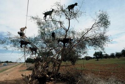
One of the undying memories everyone who drives north from Essaouira will always cherish will be his first glimpse of an argan tree. That's because every branch, heading up to the sky, will be loaded with... goats. I'm not kidding and I swear I didn't use photoshop on the picture above! To me the argan tree was always primarily about the incredible climbing tree goats first and the amazing wooden things made in Essaouira.
Last night Roland came over and he was watching some ballgame in the living room while I was writing about the deprecations of George Bush, Tom DeLay and other Republican crooked politicians on Down With Tyranny. As I finished I suddenly remembered I had something really wonderful in the kitchen that Roland didn't know about. "Close your eyes. I want you to smell something." He resisted for a minute and then, assured I didn't have a prank in mind, he inhaled, first tentatively and then greedily. He sprang out of his chair yelling "argan oil" and demanded a teaspoon of it.
It tastes scrumptiously nutty, especially the roasted stuff and it is really healthy, reducing LDLs (bad cholesterol) in the blood, and providing essential fatty acids and lots of omega-6 and vitamin E. Today I had a long talk with the manager of Erehwon who had never heard of it but promised to see if he could order some. The bottle I smuggled into the states won't last forever!
Ardmore Cathedral, County Waterford
Ardmore has to be one of the most picturesque heritage sites in Ireland. The name Ardmore comes from Ard Mór meaning The Great Height and as you can see it is well named, as the site is beautifully positioned overlooking the Irish Sea.
The site was originally said to have been founded by St. Declan some time in the fifth century, though there is little that dates to that early period visible on site. The earliest structure is probably the small building called St. Declan's Oratory that may date to the eighth century. It is said that the building houses the grave of St. Declan. The building was renovated in the eighteenth century, when a new roof was added.
The largest building on site is the remains of The Cathedral, which dates to the mid–late twelfth century. It consists of a long nave and chancel, with a fine chancel arch and a number of typically Romanesque features like the rounded doorways and windows are visible. Inside the cathedral you can find two ogham stones which provide more evidence of the early medieval phase at Ardmore. An inscription on one of the Ogham Stones has been translated to read 'the stone of Lugaid, grandson of Nia-Segmon'. You can also see a number of medieval graveslabs.
The cathedral was extensively modified in the seventeenth century, when large buttresses were added and the chancel was enlarged.
The wonderful series of early medieval sculpture set within Romanesque arcading pictured below can be seen on the western gable end of the Cathedral. The series of panels with sculpture is an unusual feature. The style of artwork and the Romanesque arcading certainly suggest it is from the time of the bishopric in around 12–13th Century, but its position probably dates to the early 17th Century, when Ardmore underwent a series of renovations and alterations. The sculptures are very worn today, and are quite difficult to make out. The larger panels underneath are a little clearer and show [from left to right], a figure on a horse, Adam and Eve, then it looks like two kneeling figures. On the second panel to the right, I believe the lower figures show the adoration of the Magi, and above them is a sculpture depicting the Judgement of Solomon. The carvings depicted in the arcading along the top are far more difficult to make out unfortunately.
The Round Tower is one of the most striking examples in Ireland. It is a little later than most, as it is believed to be twelfth century. It tapers to a height of 30m and has a doorway positioned about 4m off ground level.
The Round Tower is also unusual in the three distinct external rings, after each the wall is inset a little which adds to the dramatic tapering effect. Scholars have long pondered about the function of round towers. The debate reached a pinnacle in the mid 19th century.
One commentator suggested that they were built by the Tuatha de Dannan, a mythical tribe of warriors who were said to have invaded Ireland and eventually they transformed into otherworldly fairy figures. Another scholar suggested that the towers were built by the Danes or Vikings to look out and monitor the movements of the native Irish. The most common story about round towers was that they were built not by the Vikings but by the Irish monks as a look out and defensive feature against Viking raids. It was thought that during times of attack, the Irish monks would collect the valuables of the monastery, run to the round tower, climb up to the doorway via a rope ladder, pull this up after the last monk ascended, close the large wooden door and be safe from Viking attack. Unfortunately, this would not have been the case. The round towers would not have made a good refuge during Viking raids. Once inside the tower the fleeing populace would find themselves trapped, with no water or sanitary facilities and the wooden floors and ladders would have been susceptible to fire. Instead it is more plausible that the Round Towers were constructed as bell towers. Indeed they are known as ‘cloigh teach’ in Irish Gaelic which translates to ‘bell house’. They would have also been visible from miles around, and as such they would have acted like a signpost to weary pilgrims on the route to Ardmore.
With its beautiful setting and number of interesting medieval buildings and features Ardmore should be on your must-see list if you are in Munster. If you visit on a sunny day there are few sites to compare with it in Ireland.
To get there simply head into the village of Ardmore in County Waterford and follow the signs up the hill, it is very easy to find.
I hope you enjoy this blog, we're trying to cover as many sites as we can across Ireland. If anyone has any suggestions about sites you'd like us to cover please do leave us a comment. If you enjoy information and images of Irish heritage sites then do follow us on Facebook, Twitter and Google+ If you'd like to support us then please consider downloading an audioguide to one of Ireland's wonderful heritage sites. They are packed with original music and sound effects and are a great way of experiencing the story of Ireland. They only cost €1.99 and are fun whether you are at the site, or listening from the comfort of your own home. If you enjoy stories of the turbulent medieval period in Ireland try our guide to Viking and Medieval Dublin, visit us at www.abartaaudioguides.com for free previews and to download your free audioguide to the Rock of Dunamase or the free audioguide to the wonderful heritage town of Kells in County Meath
All photographs © Neil Jackman / abartaaudioguides.com
St. Declan's Oratory |
One of the Ogham Stones at Ardmore |
The cathedral was extensively modified in the seventeenth century, when large buttresses were added and the chancel was enlarged.
The wonderful series of early medieval sculpture set within Romanesque arcading pictured below can be seen on the western gable end of the Cathedral. The series of panels with sculpture is an unusual feature. The style of artwork and the Romanesque arcading certainly suggest it is from the time of the bishopric in around 12–13th Century, but its position probably dates to the early 17th Century, when Ardmore underwent a series of renovations and alterations. The sculptures are very worn today, and are quite difficult to make out. The larger panels underneath are a little clearer and show [from left to right], a figure on a horse, Adam and Eve, then it looks like two kneeling figures. On the second panel to the right, I believe the lower figures show the adoration of the Magi, and above them is a sculpture depicting the Judgement of Solomon. The carvings depicted in the arcading along the top are far more difficult to make out unfortunately.
The Round Tower is one of the most striking examples in Ireland. It is a little later than most, as it is believed to be twelfth century. It tapers to a height of 30m and has a doorway positioned about 4m off ground level.
The Round Tower is also unusual in the three distinct external rings, after each the wall is inset a little which adds to the dramatic tapering effect. Scholars have long pondered about the function of round towers. The debate reached a pinnacle in the mid 19th century.
One commentator suggested that they were built by the Tuatha de Dannan, a mythical tribe of warriors who were said to have invaded Ireland and eventually they transformed into otherworldly fairy figures. Another scholar suggested that the towers were built by the Danes or Vikings to look out and monitor the movements of the native Irish. The most common story about round towers was that they were built not by the Vikings but by the Irish monks as a look out and defensive feature against Viking raids. It was thought that during times of attack, the Irish monks would collect the valuables of the monastery, run to the round tower, climb up to the doorway via a rope ladder, pull this up after the last monk ascended, close the large wooden door and be safe from Viking attack. Unfortunately, this would not have been the case. The round towers would not have made a good refuge during Viking raids. Once inside the tower the fleeing populace would find themselves trapped, with no water or sanitary facilities and the wooden floors and ladders would have been susceptible to fire. Instead it is more plausible that the Round Towers were constructed as bell towers. Indeed they are known as ‘cloigh teach’ in Irish Gaelic which translates to ‘bell house’. They would have also been visible from miles around, and as such they would have acted like a signpost to weary pilgrims on the route to Ardmore.
With its beautiful setting and number of interesting medieval buildings and features Ardmore should be on your must-see list if you are in Munster. If you visit on a sunny day there are few sites to compare with it in Ireland.
To get there simply head into the village of Ardmore in County Waterford and follow the signs up the hill, it is very easy to find.
I hope you enjoy this blog, we're trying to cover as many sites as we can across Ireland. If anyone has any suggestions about sites you'd like us to cover please do leave us a comment. If you enjoy information and images of Irish heritage sites then do follow us on Facebook, Twitter and Google+ If you'd like to support us then please consider downloading an audioguide to one of Ireland's wonderful heritage sites. They are packed with original music and sound effects and are a great way of experiencing the story of Ireland. They only cost €1.99 and are fun whether you are at the site, or listening from the comfort of your own home. If you enjoy stories of the turbulent medieval period in Ireland try our guide to Viking and Medieval Dublin, visit us at www.abartaaudioguides.com for free previews and to download your free audioguide to the Rock of Dunamase or the free audioguide to the wonderful heritage town of Kells in County Meath
All photographs © Neil Jackman / abartaaudioguides.com
Not entirely travel photography related but Magnum In Motion is featuring an audio slideshow of Bruno Barbey's photographs of the construction of Shanghai's World Expo construction site and parts of its old city.
Shanghai saw the opening of the 2010 World Expo today, starting an event to herald the Chinese financial hub's return as a major world city after the spartan industrialism following the 1949 communist revolution.
According to the news reports here in the UK, no expense was spared and like the 2008 Olympics, the World Expo will showcase China's immense economic and geopolitical importance; almost bragging its power and influence.
I haven't been to Shanghai yet, but it's quite obvious the degree by which China has developed, and is continuing to develop its main cities. It's in stark contrast with the crumbling infrastructure of many large cities in the United States.
China is spending over $4.0 billion on the Expo itself, and many billions more on other improvements for this city of 20 million people. While in the United States, we are faced with economic difficulties caused by the mismanagement of the Bush Administration, the spectacle of hypocritical Tea Baggers and a catastrophic oil spill in the Gulf of Mexico.
It's depressing.
Where on Earth will YOU vote?
I could have voted in Fez
Right now, as I mentioned, I'm planning a trip to Djenne, Mopti, le pays Dogon and Timbuktu; that's all Mali. And a lot of it is relatively inaccessible without a camel-- or, thankfully, a 4WD. I planned my trip after the election. If I wasn't actively working for some many candidates, I didn't have to. Voting from abroad is way easier now than it used to be when McCain was young and you had to vote with cuneiform. Cheap joke; but when I was around 20 I was living in Afghanistan and I had to ride a horse down from the mountains to vote in the U.S. Embassy in Kabul. It's a lot easier today.
This morning I got a message from an Obama-related group called VoteFromAbroad via Facebook. They lay out the simple steps of how you can vote from anywhere in the world... even Mali or Afghanistan. They even have a YouTube:
Kalbijim from Parkga Budae
We needed lunch after a meeting this morning and somehow ended up at this chain. I was told that they specialized in these stewed pork ribs, so we went ahead and ordered one. It was tender and spicy, although also rather sweet, which is basically the reason why I won't order it again. Instead, I might try to go for the budae jjigae that I saw so many other tables ordering instead. But I'm glad that I tried this at least. Apparently this is from some city in another part of the country.
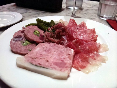
A Charcuterie Plate from Bistro du Vin
I wasn't super hungry tonight, so I just grabbed this plate of charcuterie from an outlet of Bistro du Vin tonight, and it did the job (after all, what's not to like about cured meat, especially when helped down with some wine and bread?). I leapfrogged straight to dessert after that, but ultimately this was still pretty expensive after adding in the drinks.
Knocknarea, County Sligo
If you’d like to keep up with daily images and information about Ireland’s fantastic heritage sites please consider following Abarta Audioguides on Facebook, Twitter and Instagram. |
Knocknarea and its massive cairn is the most iconic and dominant landmark in County Sligo. Legend has it that it is the final resting place of the famous warrior Queen Maeve, who is said to have been buried standing upright in her armour, still facing her ancient Ulster enemies. Although the cairn has never been excavated it is likely that instead of an angry Maeve, the cairn covers a large Neolithic passage tomb.
This enormous cairn measures almost 60 metres in diameter and stands around 10 metres high. It is within a linear arrangement of five small tombs that surround the massive cairn known as Miosgán Meadhbha.
The mountain and its cairn appear to be the focal point of a number of prehistoric tomb sites in the Cúil Irra Peninsula, along with other sites at Carrowmore and Carns Hill, forming one of Ireland’s most important and striking prehistoric landscapes. The remains of a number of small hut sites were also discovered on Knocknarea.
The walk up Knocknarea offers some of the most spectacular views in Ireland, as beautiful Co Sligo and its Atlantic coastline opens out around you. The walk up to the cairn takes roughly 30 to 45 minutes, it’s relatively steep to begin with and good footwear is advised, but the summit is broad and flat allowing you a leisurely stroll while you take in the stunning scenery. Please do not be tempted to climb or interfere with the cairn as despite its size it is a vulnerable archaeological site of great antiquity and importance.
Visiting Knocknarea is a truly wonderful experience for anyone who enjoys their history, archaeology or just a good walk with spectacular views. The site is well signposted from Sligo and has a large carpark. You'll find it at co-ordinates 54.258746, -8.574649.
If you like Knocknarea you might also enjoy Carrowkeel and Carrowmore where you can discover more evidence of Sligo’s incredible prehistoric past.
Now you can hear the story of Sligo with a free downloadable audioguide and app please see here for more details.
If you’d like to keep up with daily images and information about Ireland’s fantastic heritage sites please consider following Abarta Audioguides on Facebook, Twitter and Instagram.
Labels:
County Sligo
Location:
Unnamed Road, Co. Sligo, Ireland
FP: Tomas van Houtryve's Maostalgia
When one thinks of Foreign Policy magazine, large photographs and photo essays don't really come to mind...but that would be incorrect. The magazine regularly features photo essays from well-known photojournalist and, contrary to many online newsy magazines, does a nice job showcasing them in a large size.
This month, Foreign Policy published Maostalgia, a photo essay by Tomas van Houtryve, who traveled in the heart of China and found Mao's legacy in the most unexpected places.
For instance, he photographed in the town of Nanjie, where its government provides for all its citizens' needs, supplying them with everything from cough medicine to funerals.
A different take from the recent photo essays on glitzy China we've been accustomed to see, and which for the most part extol the virtues of the Chinese economy.
Tomas van Houtryve is a documentary photojournalist who spent much of the past five years photographing the few remaining countries still under Communist Party rule. His 2009 photo essay for FP on North Korea, "The Land of No Smiles," was nominated for a National Magazine Award.
More of his images on China can be seen here.
Strategically positioned on a peninsular that thrusts out like a finger into Lough Ree, Rindoon is one of Ireland's best preserved deserted medieval towns. The castle at Rindoon is thought to date to 1227 and was constructed by Geoffrey de Marisco. It appears that Geoffrey de Marisco was a villain on a Game of Thrones level of nastiness. He was Justiciar of Ireland between 1215 and 1228, and took full advantage of the young King Henry III by being as corrupt in his dealings in Ireland as possible. He amassed huge swathes of land and a fortune by seizing goods, lands and taxes in the Kings name and then keeping the rewards for himself. He was eventually dismissed from office in 1228. He was even excommunicated for misappropriating funds from the Church (the money was just resting in ye olde account apparently).
However he is most noted for a truly despicable event in 1234. He was a long time friend of William Marshall and his brother Richard, and when William died childless, Richard Marshall was the rightful heir to the vast lands owned by his brother. Richard was denied these lands and exiled, falsely accused of treason and associating with the Kings enemies in France by the Kings councillors in an attempt to amalgamate the huge Marshall inheritance into the Royal coffers. The councillors pressured King Henry III into ordering Geoffrey de Marisco to capture Richard Marshall, and if he succeeded de Marisco would be rewarded with all of the Marshall lands in Ireland.
Marshall and a small number of loyal men were surrounded on the Curragh of Kildare by Walter de Lacey, Lord of Meath, Hugh de Lacey, Earl of Ulster, Maurice FitzGerald, Lord of Offaly and a large number of knights and soldiers. De Marisco is said to have advised his old friend Marshall not to surrender and to fight, declaring that he would support him, however as soon as the battle started de Marisco withdrew his men, telling Marshall that he had just remembered that he was newly married to Hugh de Lacey’s sister and so could not possibly fight his brother-in-law. Despite this treachery, Marshall bravely fought on, and is said to have slaughtered six of the knights in a battle that raged for over ten hours. He fought so furiously that the others feared to approach him. They had their foot soldiers maim Marshall’s horse with lances and halberds, in its agony the horse threw Marshall at the feet of his foes, one of his enemies lifted the backplate of his armour and stabbed him in the back. Despite his grevious wounds Marshall survived, until the medical treatment he received (having his wounds probed with a red hot poker) finished him off, and the noble knight died.
De Marisco and his son William were vilified for their treachery, and were not even rewarded for their part in Marshall’s fall, as the King declared that de Marisco was in league with Marshall. The de Mariscos were declared outlaws and became pirates on the Irish sea, regularly raiding shipping to Drogheda and Dublin.
The castle that de Marisco constructed at Rindoon was one of the most important Norman castles in Connacht, and after de Marisco forfeited his lands when he was declared outlaw, the castle became a Royal possession. The castle was in the hands of a 'constable' who was responsible for its maintenence and defence, and records from the time show that money was regularly spent on the castle to bolster its defences and maintain it.
The castle is surrounded by a deep ditch and bank, and the base of the walls are clearly battered to provide protection against undermining and to deflect stones dropped from the battlements above into the front ranks of an attacking army.
The gateway is well defended with grooves showing where a portcullis would have barred the way, and murder-holes strategically positioned above so the defenders could pour boiling fats and oil down on top of the attackers.
Unfortunately the interior of the castle is in a dangerous state so access is currently restricted, but hopefully it will be opened to the public soon.
The defences of the castle held strong when the town was raided and sacked by Feilimid Ó Conchobhair in 1236, as he was unable to seize the castle. After Feilimid became King the following year in 1237, a period of peace and prosperity came to Rindoon, however it was not to last. Feilimid's son and heir Aed was far more warlike than his father, and successfully sacked Rindoon twice in 1270, in 1271 and 1272. The raid in 1272 was said to have been so bad that Rindoon was described as being 'levelled'.
Rindoon Castle was repaired by Geoffrey de Geneville the Justiciar and rich Norman Lord who had inherited Trim Castle in County Meath through marriage. This work was continued by his successor Richard d'Ufford, who spent a fortune repairing the beleaguered town. Rindoon was finally effectively destroyed Ruaidrí Ó Conchobhair captured and burnt the town and seized the castle, while the Anglo-Normans in Ireland were distracted during the invasion of Edward Bruce. There were further small attempts to reconstruct the town, but it was positioned in increasingly hostile territory, and the resurgent Gaelic tribes repeatedly raided the town before it was finally abandoned. Some of the features of the site appear to date to the sixteenth and seventeenth century so it is apparent that activity, albeit on a much more muted scale, continued sporadically at Rindoon.
The remains of a windmill are also visible at Rindoon. The earliest mention of a windmill at Rindoon was recorded in 1273 when 45 shillings was paid to Richard Le Charpentier for steel to construct the mill. A mill also appears in the 1636 maps.
These remains are likely to date to that first half of the seventeenth century. The remains are of a round stone tower three stories tall (probably still at its original height). The tower is set on top of a low mound and surrounded by a ditch, it is thought the mound may well be the remains of the site of the original medieval mill.
The church appears to be of thirteenth century date. It is a typical nave and chancel church and is positioned on a height overlooking the beautiful Lough Ree. There are a number of other medieval features to discover at Rindoon, like the stone walls that once enclosed the town, and you can still make out the plots where houses and field systems give tantalizing glimpses of everyday medieval life
Rindoon is a fantastic site to visit, and as well as the intriguing history and archaeology, it makes for a lovely walk. It is similar in feeling to the other deserted medieval town I visited in March, at Newtown Jerpoint in Co. Kilkenny. At both of these sites you get this real atmospheric feeling that the medieval past is only covered by a thin veil, that the quiet fields covered with sheep were once vibrant markets, streets and houses thronged with people going about their daily lives. A site well worth a visit!
If you would like to learn more about this incredible place I strongly recommend taking a look at The Rindoon Conservation Plan by the Heritage Council (opens as a PDF). Rindoon is roughly half way between Roscommon Town and Athlone on the N61 and it is well signposted from the road (sat nav co-ordinates N53.54389° W008.00299°), there is a small area to park your car. The main part of the site is about a 15min walk through fields, the fields are full of livestock (cattle and sheep) so do remember to bring appropriate footwear and please close all gates behind you.
I hope you enjoy this blog, we're trying to cover as many sites as we can across Ireland. If anyone has any suggestions about sites you'd like us to cover please do leave us a comment. If you enjoy information and images of Irish heritage sites then do follow us on Facebook, Twitter and Google+ If you'd like to support us then please consider downloading an audioguide to one of Ireland's wonderful heritage sites. They are packed with original music and sound effects and are a great way of experiencing the story of Ireland. They only cost €1.99 and are fun whether you are at the site, or listening from the comfort of your own home. If you enjoy stories of the turbulent medieval period in Ireland try our guide to Viking and Medieval Dublin, visit us at www.abartaaudioguides.com for free previews and to download your free audioguide to the Rock of Dunamase or the free audioguide to the wonderful heritage town of Kells in County Meath
All photographs © Neil Jackman / abartaaudioguides.com
However he is most noted for a truly despicable event in 1234. He was a long time friend of William Marshall and his brother Richard, and when William died childless, Richard Marshall was the rightful heir to the vast lands owned by his brother. Richard was denied these lands and exiled, falsely accused of treason and associating with the Kings enemies in France by the Kings councillors in an attempt to amalgamate the huge Marshall inheritance into the Royal coffers. The councillors pressured King Henry III into ordering Geoffrey de Marisco to capture Richard Marshall, and if he succeeded de Marisco would be rewarded with all of the Marshall lands in Ireland.
Marshall and a small number of loyal men were surrounded on the Curragh of Kildare by Walter de Lacey, Lord of Meath, Hugh de Lacey, Earl of Ulster, Maurice FitzGerald, Lord of Offaly and a large number of knights and soldiers. De Marisco is said to have advised his old friend Marshall not to surrender and to fight, declaring that he would support him, however as soon as the battle started de Marisco withdrew his men, telling Marshall that he had just remembered that he was newly married to Hugh de Lacey’s sister and so could not possibly fight his brother-in-law. Despite this treachery, Marshall bravely fought on, and is said to have slaughtered six of the knights in a battle that raged for over ten hours. He fought so furiously that the others feared to approach him. They had their foot soldiers maim Marshall’s horse with lances and halberds, in its agony the horse threw Marshall at the feet of his foes, one of his enemies lifted the backplate of his armour and stabbed him in the back. Despite his grevious wounds Marshall survived, until the medical treatment he received (having his wounds probed with a red hot poker) finished him off, and the noble knight died.
De Marisco and his son William were vilified for their treachery, and were not even rewarded for their part in Marshall’s fall, as the King declared that de Marisco was in league with Marshall. The de Mariscos were declared outlaws and became pirates on the Irish sea, regularly raiding shipping to Drogheda and Dublin.
The castle that de Marisco constructed at Rindoon was one of the most important Norman castles in Connacht, and after de Marisco forfeited his lands when he was declared outlaw, the castle became a Royal possession. The castle was in the hands of a 'constable' who was responsible for its maintenence and defence, and records from the time show that money was regularly spent on the castle to bolster its defences and maintain it.
The battered slope added to the walls of the castle |
The entrance into the castle |
The gateway is well defended with grooves showing where a portcullis would have barred the way, and murder-holes strategically positioned above so the defenders could pour boiling fats and oil down on top of the attackers.
Unfortunately the interior of the castle is in a dangerous state so access is currently restricted, but hopefully it will be opened to the public soon.
The defences of the castle held strong when the town was raided and sacked by Feilimid Ó Conchobhair in 1236, as he was unable to seize the castle. After Feilimid became King the following year in 1237, a period of peace and prosperity came to Rindoon, however it was not to last. Feilimid's son and heir Aed was far more warlike than his father, and successfully sacked Rindoon twice in 1270, in 1271 and 1272. The raid in 1272 was said to have been so bad that Rindoon was described as being 'levelled'.
Rindoon Castle was repaired by Geoffrey de Geneville the Justiciar and rich Norman Lord who had inherited Trim Castle in County Meath through marriage. This work was continued by his successor Richard d'Ufford, who spent a fortune repairing the beleaguered town. Rindoon was finally effectively destroyed Ruaidrí Ó Conchobhair captured and burnt the town and seized the castle, while the Anglo-Normans in Ireland were distracted during the invasion of Edward Bruce. There were further small attempts to reconstruct the town, but it was positioned in increasingly hostile territory, and the resurgent Gaelic tribes repeatedly raided the town before it was finally abandoned. Some of the features of the site appear to date to the sixteenth and seventeenth century so it is apparent that activity, albeit on a much more muted scale, continued sporadically at Rindoon.
The remains of a windmill are also visible at Rindoon. The earliest mention of a windmill at Rindoon was recorded in 1273 when 45 shillings was paid to Richard Le Charpentier for steel to construct the mill. A mill also appears in the 1636 maps.
These remains are likely to date to that first half of the seventeenth century. The remains are of a round stone tower three stories tall (probably still at its original height). The tower is set on top of a low mound and surrounded by a ditch, it is thought the mound may well be the remains of the site of the original medieval mill.
The church at Rindoon |
The defensive walls that surround the town |
If you would like to learn more about this incredible place I strongly recommend taking a look at The Rindoon Conservation Plan by the Heritage Council (opens as a PDF). Rindoon is roughly half way between Roscommon Town and Athlone on the N61 and it is well signposted from the road (sat nav co-ordinates N53.54389° W008.00299°), there is a small area to park your car. The main part of the site is about a 15min walk through fields, the fields are full of livestock (cattle and sheep) so do remember to bring appropriate footwear and please close all gates behind you.
I hope you enjoy this blog, we're trying to cover as many sites as we can across Ireland. If anyone has any suggestions about sites you'd like us to cover please do leave us a comment. If you enjoy information and images of Irish heritage sites then do follow us on Facebook, Twitter and Google+ If you'd like to support us then please consider downloading an audioguide to one of Ireland's wonderful heritage sites. They are packed with original music and sound effects and are a great way of experiencing the story of Ireland. They only cost €1.99 and are fun whether you are at the site, or listening from the comfort of your own home. If you enjoy stories of the turbulent medieval period in Ireland try our guide to Viking and Medieval Dublin, visit us at www.abartaaudioguides.com for free previews and to download your free audioguide to the Rock of Dunamase or the free audioguide to the wonderful heritage town of Kells in County Meath
All photographs © Neil Jackman / abartaaudioguides.com
A cow making good use of one of the direction stakes for a good scratch! |
Labels:
County Roscommon
Location:
Roscommon, Co. Roscommon, Ireland
Subscribe to:
Posts (Atom)