BAM! Tapas-Sake Bar in Tanjong Pagar
With a name like this, you would have thought that it was run by Emeril Lagasse. Instead, this was run by a Santi alum, although I really have no idea what the origin of the name was. Still, the Santi credentials were good enough, so I came down here for a bite after work (38 Tras Street, 6226-0500).
I was kinda let down. Yes, it was all very high quality food, but the approach to everything was a bit too delicate for me to get excited about. In that sense, it kinda reminded me a bit of Esquina: respectable food, but nothing that I'm going back to pay for again, especially at those sky high prices. Frankly the whole sake thing never worked for me either; after a few sips, I kinda wished that I had ordered wine instead.
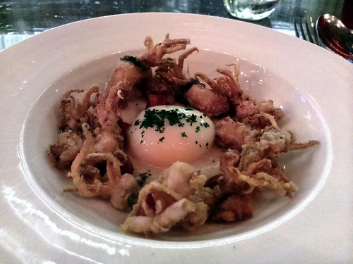
Still, there was one thing that I did get excited about, and that was the kampong egg above, which one mixed in with fried baby squid and chorizo. Conveniently enough, it was also the cheapest thing that I ordered tonight. I'd be willing to come back just for this, although hopefully the other items will be a bit more memorable next time.
Hard to Leave the Big Easy
I’m continuing to depressurize. Trying to reintegrate right and left brains. Weaning myself off of Pimm’s cups and Ramos fizzes and Sazeracs. Occasionally shaking from gumbo withdrawal.
Of course, I already miss New Orleans, and it’s only been a couple of days since I left. I actually began to pine for the city as I pulled away from the French Quarter and headed for Louis Armstrong Airport. (And if that name ain’t a promise of good times as you arrive in town and an invitation to melancholy as you leave, I don’t know what is.)
Carnival is in full swing, dressed in the traditional green, gold and purple of Mardi Gras, and heading for its ecstatic culmination next Tuesday. (The green stands for faith, the gold for power, and the purple for justice – so decreed by the membership of the New Orleans social club the Krewe of Rex over a century ago.)
Showing up for the first few days of what amounts to a week and a half of increasing dementia allows one to avoid the massive crush of yahoos and loonies looking to get completely plastered and heedlessly bare body parts by the end of the celebration. At the start, the numbers are smaller and the behavior more civilized. Nonetheless, the spirit of revelry was in the air this past weekend. Yes, there were some remnants of what a couple of locals warily/bitterly called “that weather incident.” The French Market is being renovated and, the promise of renewal aside, its husk is a sad sight. The Lower Ninth Ward is still largely a mess.
But the people are still warm and welcoming. Construction is happening throughout the town. The Quarter and Magazine Street in the Garden District are pretty much back to speed. New businesses are opening – and a few storm-devastated old businesses are reopening. The restaurants – from the familiar and classic to the recently spawned – were, as expected, producing the delectable regional cuisine that has inspired watering mouths and rave reviews - nay, poetry! - for decades.
Certainly, the music-- particularly at the clubs on Frenchmen Street in the Marigny-- was superb and rollicking and wistful and even hopeful, just like the residents who stayed or returned, and endured.
Last Friday night, pianist Ellis Marsalis-- patriarch of the renowned musical clan-- had his small ensemble cooking on the standards as usual at Snug Harbor. At d.b.a. (the New Orleans branch of the New York City/East Village brew pub), the weekend schedule was top-notch and delightfully indigenous with torchy blues-rock chanteuse Ingrid Lucia doing the early evening show on Friday, followed by some rousing frenzy from the folk-rockin’ Zydepunks; jazz crooner John Boutte and band opening the Saturday bill, with a wild R&B/Tex-Mex-fueled late show from the roots-rockin’ Iguanas; and retro le jazz hot singer/cutie-pie Linnzi Zaorski playing a happy-hour set on Sunday, with the Washboard Chaz Blues Trio wrapping up the night.
There is no greater ambassador for genuine New Orleans jazz in this day and age than the terrific, tradition-wise singer-trumpeter Kermit Ruffins, who, with his band the Barbecue Swingers, done tore up the Blue Nile on Saturday night. Very few artists can turn a club into a carnival at will. Kermit is one of them. And Monday night’s jam session at Ray’s Boom Boom Room, led by drummer/DJ Bob French, was a wonderful, improv-heavy ramble through Tim Pan Alley and the Great American Songbook.
It would be a mistake to forget the fabulous band that played Saturday night’s annual costume ball hosted by a New Orleans artist of note. The group’s horns-and-all cover of the Beatles’ “Got to Get You Into My Life,” done-- no lie-- Parliament/Funkadelic-style, almost shook the filled-to-the-rafters warehouse apart. Nor should I neglect to mention the amazing Sunday night all-45 rpm vintage-soul-and-rockabilly DJ set at the Saint bar in the Garden District. And the melodies that waft from legendary venues, hot spots and dives as you walk past or are produced by street performers that are far too accomplished to be relegated to passing the hat.
This is on top of the parades (raining beads and doubloons on fervent crowds of onlookers) by the krewes that roll through the area on the early weekend. And the yearly Krewe of Barkus dog parade through the Quarter, with the 2008 theme “Indiana Bones & the Raiders of the Lost Bark”-- complete with canine fashion plates and their owners in Indy fedoras, pushing along lovingly-forged Arks of the Covenant on wheels.
My last evening in town featured an orgy of exquisitely delicious food shared with three friends Uptown at Jacques-Imo’s restaurant-- cornbread muffins, stuffed shrimp, fried green tomatoes, onion rings, succulent glazed duck, blackened redfish, collard greens, and strawberry shortcake, washed down with Abita’s Mardi Gras Bock. We topped it off with nightcaps at La Crepe Nanou, where we talked music and the beauty of Southern Louisiana with Vicki and Debbi Peterson of the Bangles who were in town for a couple of shows.
Like Vicki and Debbi, I harbor an inordinate amount of love for the city of New Orleans. Call it what you will: Nola, the Big Easy, the Crescent City, the City That Care Forgot. Its socio-economic problems and precarious, post-Katrina condition notwithstanding, it’s like no other place in America-- a cultural cauldron rich with history, art, music, culinary delights, and the joy of living. I encourage everyone to visit and drop a little cash there. The Jazz & Heritage Festival is coming up in the spring-- and, judging from schedule, it looks like it’s gonna be one to remember. So go. Or visit some other time. Help the regeneration of this national treasure. You will be repaid a thousand times over with peak experiences that will linger in your memory long after you return to your everyday biz.
Nong Khai Beer House at Golden Mile
In all of the years that I've been in Singapore, I had heard about all of the Thai food available at the Golden Mile Complex, but I had never been. Tonight, we happened to be nearby, and figured that we'd go see what all of the fuss was about. There were a couple of very large shops inside, but I heard a lot of English and Chinese being spoken there.
I thus went to the other end of the hall to try to see if I could overhear some Thai instead, and surely enough, this place (5001 Beach Road #01-73/74) had a group of working girls seated, presumably getting ready to start their shift upstairs soon. When we found that the waitress could hardly speak English (and a tray of raw and unfamiliar veggies came out), I knew that we had chosen the right spot.
And yes, it was good. We told them to make it spicy, and everything ended up providing a nice burn, including not just that pig skin salad above, but also a papaya salad and even the tom yum soup which had a heavy shot of red chili oil on top. We actually ended up ordering a bit too much food as a result, but were happy to have eaten here. I wonder if some of those smaller counter-style shops in this building are any good.
Australian Scientists Explore Lost World For First Time
A team of Australian researchers have quite literally gone where no man has gone before. Scientists from James Cook University recently crossed into a region called Cape Melville, which is completely cut off from the outside world by millions of large boulders that make passage into the remote mountain range nearly impossible. The team of four used a helicopter to gain access however and what they found inside was quite amazing.
Once inside the cape, the team determined that the entire region, which is encircled by impenetrable mountains, is 9 miles (14 km) long and roughly 3 miles (5 km) across. The region contains remnants of a rainforest left over from Gondwana, a reference to an ancient super-continent that existed millions of years ago. They also discovered a variety of new species as well, including three very unique reptiles. Those species included a new frog that lives under boulders and is capable of hatching its eggs without water and a skink that hunts insects by leaping from rock to rock. A third species was the most impressive however, an odd looking gecko that is unlike anything anyone had seen before.
The initial expedition to explore Cape Melville lasted just four days with the team seeing less than a tenth of the area contained there. The group is already planning a return trip to plumb further into the depths of the region to see what else they can find. The team believes that considering what they discovered in just a preliminary scouting mission, they could find some really unique species of birds, plants and even mammals once they really get the opportunity to check out the forests there. Considering that the Cape has been evolving on its own, almost completely cut off from the rest of the world for millennia, there could be some very unique creatures just waiting to be discovered.
These store always fascinate me. I love that our world is so vast that we still don't have regions to explore, even in the age of satellite mapping, GPS navigation and instant communications. It must have been a humbling experience for these scientists to become the first humans to step into this lost world and lay eyes on the wonders there for the first time. What an amazing world we live in.
While most of the attention in the climbing community has been centered on the Himalaya once again this fall, there have been other bold climbing adventures taking place in other parts of the world as well. For example, a team of four big wall climbers traveled to a remote region along the border of China and Kyrgyzstan in search of new challenges to test their skills. They found that challenge in the form of a mountain called Kyzyl Asker, a 5842 meter (19,166 ft) tower with a 1220 meter (4000 ft) face that required two weeks to complete.
In late August, Sean Villanueva O'Driscoll, Nicolas Favresse, Stéphane Hanssens and Evrard Wendenbaum gathered in China with no specific climbing objective in mind. They had read about a region in the Tien Shan Mountain Range that offered excellent opportunities to tackle unclimbed routes across a wild, rugged region that is seldom visited by outsiders.
After clearing some logistical hurdles and gathering what they though were the right permits, they set out for their destination using camels to shuttle their gear. After setting up Base Camp, they surveyed he area and settled on Kyzl Asker as their target. But they soon discovered that the permit they had been issued was meant for trekking only and not climbing. It also had a number of other restrictions that were problematic to the expedition as well. Luckily they had a Chinese liaison officer with them who helped get the issues resolved so they could proceed.
Once the team had its objective picked out, they began moving their gear to Advanced Base Camp so they could being the ascent. Of course, these types of climbs are never easy and there are always unexpected challenges along the way. The four men had to deal with altitude, cold temperatures, constantly changing weather, illness and a host of other issues. Eventually they did climb the wall, but it took them 14 days to do so, topping out on September 22.
You can read a full account of the China Jam Expedition, as it has come to be known, on the Petzl blog. Evrad also wrote extensively about the climb as well, posting updates to his blog too. Those are in French however, so if that isn't a language you're proficient in, you'll need to run the reports through Google Translate first. I think it'll be worth your effort however, as this sounds like it was quite an experience.
Finally, check out the video below to see how the expedition not only got its name but also what the boys did to pass the time while suspended on Kyzyl Asker's big wall. These guys have quite a career ahead of them when they're done climbing.
China Jam - Portaledge Song from Evrard Wendenbaum on Vimeo.
In late August, Sean Villanueva O'Driscoll, Nicolas Favresse, Stéphane Hanssens and Evrard Wendenbaum gathered in China with no specific climbing objective in mind. They had read about a region in the Tien Shan Mountain Range that offered excellent opportunities to tackle unclimbed routes across a wild, rugged region that is seldom visited by outsiders.
After clearing some logistical hurdles and gathering what they though were the right permits, they set out for their destination using camels to shuttle their gear. After setting up Base Camp, they surveyed he area and settled on Kyzl Asker as their target. But they soon discovered that the permit they had been issued was meant for trekking only and not climbing. It also had a number of other restrictions that were problematic to the expedition as well. Luckily they had a Chinese liaison officer with them who helped get the issues resolved so they could proceed.
Once the team had its objective picked out, they began moving their gear to Advanced Base Camp so they could being the ascent. Of course, these types of climbs are never easy and there are always unexpected challenges along the way. The four men had to deal with altitude, cold temperatures, constantly changing weather, illness and a host of other issues. Eventually they did climb the wall, but it took them 14 days to do so, topping out on September 22.
You can read a full account of the China Jam Expedition, as it has come to be known, on the Petzl blog. Evrad also wrote extensively about the climb as well, posting updates to his blog too. Those are in French however, so if that isn't a language you're proficient in, you'll need to run the reports through Google Translate first. I think it'll be worth your effort however, as this sounds like it was quite an experience.
Finally, check out the video below to see how the expedition not only got its name but also what the boys did to pass the time while suspended on Kyzyl Asker's big wall. These guys have quite a career ahead of them when they're done climbing.
Ramyun & Soju Korean Cuisine
This place bills itself as "Singapore [sic] First Korean Ramyun Restaurant" (1 Tras Link #01-03, 9436-0710). And yes, that was basically a bowl of instant noodles, which seems rather odd to be served at a restaurant. College dorm rooms seem to be the more appropriate venue for that!
But I guess it wasn't that different from the way that Teumsae Ramyeon was served at a restaurant in Seoul. Are instant noodles commonly served at restaurants in Korea? Anyway, what perhaps might be more interesting to come back for was the single serving of budae jjigae that I saw on the menu, which, I suppose also has instant noodles in it.
Loughcrew, County Meath
Ireland is particularly blessed with some incredible prehistoric passage tomb cemeteries, Carrowmore and Carrowkeel in Sligo, the famous Brú na Bóinne (Bend of the Boyne) sites including Newgrange, Knowth and Dowth, and this one, Loughcrew near the village of Oldcastle in County Meath. Passage tombs are named after the passageway that generally leads to a burial chamber covered by a circular mound. The mound may be of earth like the examples at Newgrange or Knowth, or stone cairns like this example at Loughcrew. The passageways are generally narrow, lined with orthostats (upright slabs) and roofed with lintels (flat slabs).
The most striking features of the archaeological landscape of Loughcrew are the three large cairns that dominate the summit of three steep hills, Patrickstown, Carnbane West and Carnbane East. It is Carnbane East that is most visited as it has the largest of the tombs, Cairn T, that appears to be the focal point of the whole cemetery.
Cairn T dates back to approximately 3000 BC. On the summit of Carnbane East, Cairn T is surrounded by a number of smaller tombs. The large cairn measures around 35m in diameter and this passage tomb has a cruciform shaped chamber and some of the finest examples of Neolithic art in Ireland. If you visit during the Autumn or Vernal (Spring) equinox you can witness sunlight entering the chamber to illuminate the inside of the tomb.
Entering the tomb itself is an incredible experience, the passageway is lined with large orthostats that display intricate carvings, wherever you look you see spirals, lines, lozenges, zigzags, circles and cup marks.
The artwork was embedded into the stones by picking, pecking and incising with a harder stone tool, and often uses the natural contours of the stone as design features. Many of the symbols at Loughcrew are found at the other passage tomb sites in Ireland.
What all these symbols mean is difficult to ascertain, some believe that they represent the artwork produced during states of altered consciousness, perhaps through shamanic ritual or consumption of mind-altering mushrooms or herbs.
Perhaps they were abstract representations of astronomical features, or perhaps simply abstract art (though as the symbols appear regularly at a number of passage tomb sites from this period surely the symbols had real meaning).
I think that looking at the spectacular equinox stone, that the symbols look to be representing natural plants, fruits, ferns and flowers. Perhaps the famous spirals and circles of megalithic art represent tree rings, a visible marker of the passing of time for these Neolithic farmers.
If the depictions on the equinox stone are plant life, it makes sense in a way that these symbols are illuminated at the Spring equinox when the land begins to come to life again, and the Autumnal equinox when the rich bounty of the land can be harvested.
I must state though, these are just theories. To paraphase the famous archaeologist George Eogan, who excavated the passage tomb at Knowth, we can never discover what any of the artwork truly means as it is impossible for us to known the minds and emotions of a people who did not know how to write and who are separated from us by 4000 years.
The Hag's Chair is one of the kerbstones that surround Cairn T, it displays megalithic art but unfortunately the carvings are very difficult to make out today, though you can just about make it out in the picture below. More clear is the cross inscribed on the seat, it possibly represents the use of the stone as a Mass Rock during penal times. It was possibly also used as a ceremonial or inauguration chair during the early medieval period.
The Irish name of Loughcrew, Slieve na Calliagh is thought to derive from Sliabh na Cailli, – The Hill of the Witch. Folklore has it that the monuments at Loughcrew were formed when a witch called An Cailleach Bhéara, was challenged to drop an apron full of stones on each of the three Loughcrew peaks, if she succeeded she would be proclaimed the ruler of all Ireland. She was successful on the first two peaks, but missed the third and fell to her death. An early eighteenth century poem commonly attributed to Jonathan Swift recounts the tale:
Determined now her tomb to build,
Her ample skirt with stones she filled,
And dropped a heap on Carnmore;
Then stepped one thousand yards, to Loar,
And dropped another goodly heap;
And then with one prodigious leap
Gained Carnbeg; and on its height
Displayed the wonders of her might.
And when approached death’s awful doom,
Her chair was placed within the womb
Of hills whose tops with heather bloom.
Poem via the excellent Voices from the Dawn website
Loughcrew is one of the most rewarding sites to visit in Ireland, and a true must-see for anyone who visits the Boyne Valley. In comparison to Newgrange, Loughcrew is rarely visited, and you can enjoy perhaps a more intimate experience with the Neolithic passage tomb builders. If you visit between the 30th May and 28th August you can avail of free guided tours by Office of Public Works staff (see here for more details), if you visit before or after those dates you can get the key by leaving a deposit with Loughcrew Gardens so you can enter the tomb yourself, it is such a wonderful experience I cannot recommend it highly enough. You will find Loughcrew at these co-ordinates 53.744672,-7.112483, about 3km south-east of Oldcastle off the R163 in County Meath (see our map for more details).
There is a small carpark at the bottom of the hill, but no toilet or facilities are on site. Cairn T is at the summit of a steep hill, so please wear suitable footwear and follow the wooden directional stakes to the top. You will be rewarded by some spectacular views of County Meath as well as encountering a truly wonderful archaeological site.
I hope you enjoy this blog, we're trying to cover as many sites as we can across Ireland. If anyone has any suggestions about sites you'd like us to cover please do leave us a comment. If you enjoy information and images of Irish heritage sites then do follow us on Facebook, Twitter and Google+ If you'd like to support us then please consider downloading an audioguide to one of Ireland's wonderful heritage sites. They are packed with original music and sound effects and are a great way of experiencing the story of Ireland. They only cost €1.99 and are fun whether you are at the site, or listening from the comfort of your own home. If you enjoy stories of the turbulent medieval period in Ireland try our guide to Viking and Medieval Dublin, visit us at www.abartaaudioguides.com for free previews and to download your free audioguide to the Rock of Dunamase or the free audioguide to the wonderful heritage town of Kells in County Meath
All photographs © Neil Jackman / abartaaudioguides.com
The most striking features of the archaeological landscape of Loughcrew are the three large cairns that dominate the summit of three steep hills, Patrickstown, Carnbane West and Carnbane East. It is Carnbane East that is most visited as it has the largest of the tombs, Cairn T, that appears to be the focal point of the whole cemetery.
Cairn T dates back to approximately 3000 BC. On the summit of Carnbane East, Cairn T is surrounded by a number of smaller tombs. The large cairn measures around 35m in diameter and this passage tomb has a cruciform shaped chamber and some of the finest examples of Neolithic art in Ireland. If you visit during the Autumn or Vernal (Spring) equinox you can witness sunlight entering the chamber to illuminate the inside of the tomb.
Entering the tomb itself is an incredible experience, the passageway is lined with large orthostats that display intricate carvings, wherever you look you see spirals, lines, lozenges, zigzags, circles and cup marks.
The artwork was embedded into the stones by picking, pecking and incising with a harder stone tool, and often uses the natural contours of the stone as design features. Many of the symbols at Loughcrew are found at the other passage tomb sites in Ireland.
What all these symbols mean is difficult to ascertain, some believe that they represent the artwork produced during states of altered consciousness, perhaps through shamanic ritual or consumption of mind-altering mushrooms or herbs.
Perhaps they were abstract representations of astronomical features, or perhaps simply abstract art (though as the symbols appear regularly at a number of passage tomb sites from this period surely the symbols had real meaning).
I think that looking at the spectacular equinox stone, that the symbols look to be representing natural plants, fruits, ferns and flowers. Perhaps the famous spirals and circles of megalithic art represent tree rings, a visible marker of the passing of time for these Neolithic farmers.
Sunlight illuminates this beautifully decorated Equinox Stone at the Autumn and Spring Equinox |
I must state though, these are just theories. To paraphase the famous archaeologist George Eogan, who excavated the passage tomb at Knowth, we can never discover what any of the artwork truly means as it is impossible for us to known the minds and emotions of a people who did not know how to write and who are separated from us by 4000 years.
A decorated lintel stone above one of the chambers, see how they used the natural contours of the rock as part of the design |
The 'Hag's Chair', can you make out the megalithic art near the base of the stone? Circles, spirals and cup marks can be seen |
The Irish name of Loughcrew, Slieve na Calliagh is thought to derive from Sliabh na Cailli, – The Hill of the Witch. Folklore has it that the monuments at Loughcrew were formed when a witch called An Cailleach Bhéara, was challenged to drop an apron full of stones on each of the three Loughcrew peaks, if she succeeded she would be proclaimed the ruler of all Ireland. She was successful on the first two peaks, but missed the third and fell to her death. An early eighteenth century poem commonly attributed to Jonathan Swift recounts the tale:
Determined now her tomb to build,
Her ample skirt with stones she filled,
And dropped a heap on Carnmore;
Then stepped one thousand yards, to Loar,
And dropped another goodly heap;
And then with one prodigious leap
Gained Carnbeg; and on its height
Displayed the wonders of her might.
And when approached death’s awful doom,
Her chair was placed within the womb
Of hills whose tops with heather bloom.
Poem via the excellent Voices from the Dawn website
Loughcrew is one of the most rewarding sites to visit in Ireland, and a true must-see for anyone who visits the Boyne Valley. In comparison to Newgrange, Loughcrew is rarely visited, and you can enjoy perhaps a more intimate experience with the Neolithic passage tomb builders. If you visit between the 30th May and 28th August you can avail of free guided tours by Office of Public Works staff (see here for more details), if you visit before or after those dates you can get the key by leaving a deposit with Loughcrew Gardens so you can enter the tomb yourself, it is such a wonderful experience I cannot recommend it highly enough. You will find Loughcrew at these co-ordinates 53.744672,-7.112483, about 3km south-east of Oldcastle off the R163 in County Meath (see our map for more details).
There is a small carpark at the bottom of the hill, but no toilet or facilities are on site. Cairn T is at the summit of a steep hill, so please wear suitable footwear and follow the wooden directional stakes to the top. You will be rewarded by some spectacular views of County Meath as well as encountering a truly wonderful archaeological site.
I hope you enjoy this blog, we're trying to cover as many sites as we can across Ireland. If anyone has any suggestions about sites you'd like us to cover please do leave us a comment. If you enjoy information and images of Irish heritage sites then do follow us on Facebook, Twitter and Google+ If you'd like to support us then please consider downloading an audioguide to one of Ireland's wonderful heritage sites. They are packed with original music and sound effects and are a great way of experiencing the story of Ireland. They only cost €1.99 and are fun whether you are at the site, or listening from the comfort of your own home. If you enjoy stories of the turbulent medieval period in Ireland try our guide to Viking and Medieval Dublin, visit us at www.abartaaudioguides.com for free previews and to download your free audioguide to the Rock of Dunamase or the free audioguide to the wonderful heritage town of Kells in County Meath
All photographs © Neil Jackman / abartaaudioguides.com
More visitors enjoying the spectacular views from Loughcrew |
Labels:
County Meath
Location:
Corstown, Co. Meath, Ireland
ME AND MATT DAMON IN TANGIER
When I first drove down to Morocco from Spain in 1969 I had heard enough about Tangier to think I should avoid it. We took the ferry from Algeciras to Ceuta (a cheaper alternative than Algeciras-Tangier). Ceuta is technically part of Europe-- the last Spanish enclave in Morocco, just a couple hours drive northeast of Tangier. We headed for Tetouan instead, avoiding Tangier entirely. At least for a while. We drove all through Morocco, loving it-- I've been back a dozen times since-- and then decided we were old Moroccan hands enough to brave the weirdness of Tangier. I must have picked up my preconception about Tangier from meditations on Paul Bowles' most brilliant novel The Sheltering Sky-- although they were strictly my own meditations, Bowles having loved Tangier so much that he decided to live there... forever. It didn't take me long to start liking it either.
Yesterday I went to see The Bourne Ultimatum, which takes place in Moscow, London, Madrid, New York and... Tangier. I've never been to Moscow but the movie didn't evoke anything special for me geographically in the other cities-- except Tangier. The scenes-- shot on location, of course-- were beautiful, action-packed, exciting and
The last time I was in Tangier, December, 2005, I was already thinking about starting a blog and I took some notes and pictures and wrote it up. These days I wouldn't think about leaving Tangier out of a Moroccan itinerary. It's a sophisticated, exotic and unique city, very different from any other place in the country. The energy is powerfully kinetic-- young and vibrant and bursting at the seams. It's pretty cosmopolitan and very much it's own thing.
Here's some footage of two chase scenes shot in Tangier.
Roscommon Castle, County Roscommon
In the early 13th century, the Gaelic Kingdom of Connacht was already weakened by a series of civil wars among the O’Conors, who were its native provincial overkings. In 1235 an Anglo-Norman noble, Richard de Burgo, invaded Connacht with an army of 500 highly trained and well equipped knights and all their foot soldiers and camp followers. The war was relatively short and certainly bloody. Immediately, the conquerers began to build castles and walled towns, as they had done in the south and east of the country, however parts of the west still offered strong resistance to the Anglo-Normans and held out. It was 1262 before the site of Roscommon Castle was chosen and works began in 1269, the site was chosen as it was formerly on the shores of Lough Nen, a large shallow lake that has since disappeared due to hydrological changes over the centuries. The O’Conors had a crannóg on the lake, and by constructing the castle in the heartland of the O’Conor Kingdom, the Anglo-Normans sought to send out a message about who was now the main power in Connacht.
The castle was constructed on the orders of the powerful King Edward I of England, he was a successful military minded King, and he used strategically constructed castles to dominate territories and had used this technique to successfully subdue the Welsh. Roscommon Castle is constructed in a very similar style to those great fortresses in Wales like Harlech, Caernarfon and Conwy.
Roscommon Castle encloses an area of about 45m by 50m and originally would have had a large gateway in the middle of the eastern wall flanked by two large D shaped towers, similar to the entrance to Castleroache in County Louth. The large stone walls also had projecting D shaped towers at each of the four corners, and another smaller gateway led to the west. It is through this gateway that you enter the site today, and as you pass through it you can still see defensive features like murder holes (openings in the ceiling through which the defenders would have poured boiling fat or oil, or threw down large rocks or quicklime to maim and blind the attackers). The castle would have also been surrounded by a moat and possibly by a timber palisade fence giving a strong outer defence.
Like the castle at nearby Rindoon, Roscommon Castle also found itself repeatedly under attack and siege by the O’Conors and their Gaelic allies. It appears that the O’Conors succeeded in taking the castle by around 1340 and they held it for nearly two hundred years. In 1569 the castle was captured by the Tudor Lord Deputy of Ireland, Sir Henry Sidney. The castle was granted to Sir Nicholas Malby, who spent a vast sum in modernizing and remodelling parts of the castle to make it more of a fashionable Renaissance dwelling rather than a bleak medieval fortress. However Malby also made sure that the defensive features of the castle were well maintained and that was put to the test during the Nine Years War when the castle found itself under siege by Hugh O’Donnell in 1596 and 1599. The castle saw action during the Confederate Wars of the 1640‘s, until Oliver Cromwell’s forces seized Roscommon Castle in 1652 and destroyed the fortifications. A fire in 1690 did massive amounts of damage to the castle and it was left to fall into disrepair through the eighteenth and nineteenth centuries.
Roscommon Castle today is free to enter and is a great site to explore. Situated in the grounds of Loughnaneane Park and Playground, it’s very accessible site and fun for children. The castle is down a small lane off Castle Street in Roscommon Town. It is signposted, but the lane is pretty small so easy to miss (we drove straight past it the first time). If you have time I do recommend a visit to Rindoon Deserted Medieval Town as well, it's an amazing site on a nice day. You'll find it between Roscommon and Athlone off the N61, here's our blog article about it http://timetravelireland.blogspot.ie/2013/06/rindoon-deserted-medieval-town-county.html
I really hope you enjoy this blog. Please do check out our map page to see if we’ve covered any sites in your area. If you’d like to keep up with daily posts about Ireland’s amazing heritage sites then you can follow us on Facebook, Twitter and Google+. We’d love to hear from you if you have any suggestions for sites to visit or any feedback about my blog.
I also provide downloadable audioguides to Irish heritage sites through my company Abarta Audioguides. Many of these are available absolutely free to download and are packed with original music and sound effects, they are a fun way of discovering the story of Ireland through its places visit www.abartaaudioguides.com to discover the sites we have covered. Why not try a free one like The Rock of Dunamase, Kells Heritage Town or the M6 A Route Through Time?
All photographs © Neil Jackman / abartaaudioguides.com
Labels:
County Roscommon
Location:
Castle Street, Roscommon, Ireland
The Travel Photographer's 2011 Photo~Expeditions™
I am planning my forthcoming Photo~Expeditions™ for 2011, and thought I'd write a heads-up concerning the direction these will take in the next year.
After some deliberation, I've decided to further accentuate the travel-documentary thrust of my photo~expeditions, and reduce the maximum number of participants to only 5 (excluding myself) on each trip. My recent expeditions have become so popular that they've swelled up to 9-10 participants, and generated long waiting lists. As of 2011, participation will no longer be based on "first registered first in", but will be based on a portfolio viewing and other criteria.
I intend to maximize the photo-journalism and travel-documentary components of my photo~expeditions even further, and largely focus on story-telling...and add a multi-media workshop element to them. This is the future of photography, and I fully intend to structure my photo~expeditions accordingly.
Here's an example of what I mean:
One of the photo~expeditions I intend to lead in summer 2011 is to Kashmir. I will announce its itinerary and the terms in due course, however it will be restricted to 5 photographers (excluding me).
The photographers will have visual and intellectual interest in Kashmir's Islamic culture, would have previously traveled to India, would be self-starters, have an affinity for photo-journalism & travel documentary photography, and want to work on individual projects and produce photo essays.
I chose Kashmir as an example because it's a destination that lends itself very well to both documentary photography (which is the objective of my photo~expeditions) and "pretty picturing" (which is not my aim). The overriding purpose in Kashmir will be to document its rich culture, its people and their faith. Will we photograph Dal Lake at dawn? Yes we will, but the major thrust will be on documenting the culture, and on projects of human interest.
Whether it's Kashmir, Kerala & Gujarat, Kathmandu, Havana, China, Siem Reap, Vietnam or any other of my possible 2011 destinations, carefully selecting participants and capping their number to 5, will accentuate the travel-documentary philosophy that I gained a reputation for, and will further enhance the quality of my photo~expeditions.
For further insight, here are a couple of my older posts (a) and (b) defining my philosophy behind my photo~expeditions. You'll find these quite interesting.
Here is an updated description of my photo~expeditions on my website.
Video: Speedflying Through Eastern European Mountains
Speedflying is an interesting mix of paragliding and skiing. It usually involves someone starting at the top of a mountain and skiing down the slopes, only to have their glider catch the wind and allow them to float over cliffs, trees, or just about any other obstacle that gets in the way. In the video below, the skier starts at the summit of Kasprowy Wierch, a mountain located along the border of Poland and Slovakia. The ride back down is certainly not along the route that most take however. This looks like scary fun.
Sunset speed-fly from Kasprowy Wierch 27.11.13 from bartoszplewa on Vimeo.
International Herald Tribune has posted an AP story on the new IMAX film The Alps which I've mentioned briefly a few times already. This is the film that follows John Harlin III up The Eiger on the same route that killed his father nearly 40 years ago. The climb was the inspiration for Harlin's book The Eiger Obsession.
The article talks about Harlin climbing in his father's footsteps, even as his own nine year old daughter watches through a telescope from the chalet below. Harlin III was nine years old himself when his father fell off the face of the Eiger while pursuing his dream to climb the "Eiger Direct" route.
This is the first "review" of the film that I've seen however, and it comes across as nothing short of glowing. The film looks great, as you would expect from an IMAX film, and goes to great lengths to capture an accurate portrayal of what it's like to climb a big mountain face in the Alps. The BIGGEST face in the Alps as a matter of fact.
The film sounds amazing, and I can't wait to see it. Unfortunately, it isn't playing in my area yet, nor is listed on the IMAX website, so I'm not sure when it's coming. But I'll keep my eyes peeled, and when I do get a chance to see it, I'll be sure to post my thoughts here. I'm also plugging away on the book, but with a busy week ahead, I'm not sure I'll be able to post a review before I leave for Kili on Saturday. With a little luck, I'll get it finished, otherwise I'll have to post it upon my return.
Lough Gur, County Limerick
If you enjoy our blog posts and would like to see daily pictures and information about Irish archaeology, history and heritage please follow us on Facebook, Twitter, Google+ and Instagram
Lough Gur in County Limerick is one of the most important and remarkable archaeological landscapes in Ireland. This small, horseshoe shaped lake has been surrounded by human settlements and activity going back over 5,000 years ago to the first farmers in the Neolithic period, though it is likely that this area was occupied even earlier, during the Mesolithic, though as yet no archaeological evidence has been found dating to this period.
The site is possibly most famous for its Neolithic settlement. Several houses, forming a small village, have been excavated on the south-facing slopes of the Knockadoon peninsula, which extends out into the lake. Both rectangular and circular houses were discovered. They were constructed by driving double rows of posts in 1m apart, these posts supported a hipped roof and screens made from woven hazel rods known as wattle. The screens were covered in daub, a mix of dung, clay and straw which when dried, would have been an effective breathable, but water and draft-proof, wall. The houses may have been insulated with a layer of earth sods, reeds or straw. An example of one of the rectangular buildings and a circular building have been reconstructed and now serve as Lough Gur’s Interpretation Centre.
The Centre itself is very well laid out, with great information on the archaeology, history and folklore of Lough Gur. It has a number of superb reproductions of the incredible artefacts discovered at Lough Gur, and has informative interactive panels and exhibits making it fun for all ages. The visitor centre is an essential introduction to the complexity of archaeology in the region.
The foundations of an early medieval structure and field systems at the 'Spectacles' |
The foundations of one of the circular stone built ringforts (or cashels) at Carraig Aille |
When you have finished your visit to Knockadoon, a short drive up the road will bring you to the cashels of Carraig Áille. These well-preserved early medieval stone ringforts have quite spectacular views, and are well worth the short climb up a hill. I will be featuring these forts in their own forthcoming blogpost.
The Lough Gur Wedge Tomb |
The lovely and peaceful Teampall Nua |
Our next stop again just minutes along the road was the church ‘Teampall Nua’. This church is thought to date to the seventeenth century (though some architectural features look more medieval to me). It replaced an older chapel used by the Earls of Desmond.
Our final stop was Grange Stone Circle located just on the west of the lake and very easily accessible from the Limerick–Killmallock Road (R512). This stone circle is just incredible, it is massive measuring nearly 50m in diameter. It is a near perfect ring of 113 contiguous stones (all the stones are touching). The entrance is marked with the tallest stones that are mirrored on the opposite side of the circle, apparently forming an alignment with the midsummer moon. The site is spectacular and will certainly feature in a separate blog post.
As an archaeologist I found the visit to Lough Gur to be almost like a pilgrimage. It is such a beautiful part of the country, and our visit barely scratched the surface of the sheer wealth of archaeological and historical sites clustered around the lake. A visit to Lough Gur is an absolute must for anyone with an interest in archaeology and history! You can find more information on Lough Gur from their website at http://www.loughgur.com/
If you have a suggestion for a site I’d love to hear it, please let us know by dropping us a line at info@abartaaudioguides.com or on Facebook, Twitter or Google+, where you can keep up with daily pictures and information about Ireland's wonderful heritage sites.
If you'd like to support us please consider downloading one of our audioguides from www.abartaaudioguides.com, they are packed with great facts, information, stories and legends from Ireland's iconic sites. They are designed to be fun and informative whether you are visiting the sites or from the comfort of your own home, so if you are looking to escape to the Court of Brian Boru the next time you are doing household chores download one of our guides and let us whisk you off to ancient Ireland!
Labels:
County Limerick
Location:
Lough Gur, Co. Limerick, Ireland
A Negitoro Don from Tampopo
I needed something healthy yet with protein tonight, so I ended up selecting this negitoro don from Tampopo's menu. It went down the hatch in a jiffy.
Planning A Trip To San Miguel De Allende
I know, I know, I know, I know, I know... I just got back from a month in Mali and Senegal and I was in Mexico City just a few months ago. But prices in Mexico are so cheap now and two of my friends, Roland and Helen, both have some time off in February and are both jonesin' for a trip to Guanajuato, and another friend, Allisse just got back from there raving about how fantastic it is. And, I feel kind of overjoyed because Obama just announced he's tossing another of Bush's horrible policies, the so-called "Mexico City Policy," into the garbage can of history.
Obama's second full day as president falls on the 36th anniversary of Roe v. Wade, the 1973 Supreme Court decision legalizing abortion in the United States.
The sources said Obama may use the occasion to reverse the "Mexico City policy" reinstated in 2001 by Bush that prohibits U.S. money from funding international family planning groups that promote abortion or provide information, counseling or referrals about abortion services. It bans any organization receiving family planning funds from the U.S. Agency for International Development from offering abortions or abortion counseling.
The "Mexico City policy," commonly referred to by critics as "the global gag rule," was devised by President Ronald Reagan in 1984 at a population conference in Mexico City.
So... San Miguel de Allende here we come! San Miguel is a beautiful, artsy, historic town in central Mexico with perfect weather-- today it is 73 F and sunny-- all year round. It was designated an historic landmark seventy years ago and the colonial heritage is preserved and taken seriously. No neon signs or any of the other hideous trappings of gaudy Las Vegas style tourism that have ruined so many places in Mexico. It's all about narrow, cobblestone streets and the architecture goes back and forth from baroque to gothic. The city has a thriving and vibrant community of artists and writers from all over the world.
So this is what I did. I called Mexicana Airlines and made a reservation for a direct flight to Leon, the capital of Guanajuato and then I booked a stunning villa with 4 bedrooms. The roundtrip airfare from L.A. is $321 and the villa costs $1,550 for the week. Now I'm doing my research on the other colonial towns in the area we might want to visit, like Guantajuato, Dolores Hidalgo and San Luis de la Paz.
UPDATE: POSADA CORAZON
A reader, Eric, sent me a great tipfor the trop: a wonderful inn he had stayed at, Posada Corazon that serves organic breakfasts, even to non-guests (with a reservation). It looks like just the kind of place I'd love.
Taiwanese Sanbeiji on United (not!)
Yes, I took a photo of the in-flight magazine. Why? Because I ordered this dish, and yet didn't actually get it. Apparently they started heating these things when we were getting ready to push back from the gate in Hong Kong. But then we had to deplane while they fixed a mechanical problem...and when we got back on board over six hours later, the food had gone bad already, with nothing left to eat but instant noodles.
So I can only imagine what this Taiwanese three-cup chicken was going to taste like (it was featured in the magazine because UA is starting Taipei flights again). And that was a pretty brutal nearly 40 hours door to door from Boston...I should probably fly Lufthansa via Munich next time (or Turkish Airlines or even Emirates?). BTW, United was serving cioppino in business class on the way out of SFO today. There goes my theory about soup in first class.
Adventure Blog On Another Break!
Just a quick programming note. I'm out of town the next few days and probably won't be able to update again until Friday. No, I'm not off on another great adventure (I wish!) but instead I have to attend a convention for the day job and earn my keep for a change. It's not all bad though, as I'll be sitting on a panel discussion and making a presentation as well. I promise to be posting updates again as soon as possible.
Island Creek Oyster Bar in Boston
Nice place. We needed a venue for a team dinner tonight, and this upscale seafood place came up as a suggestion (500 Commonwealth Avenue, 532-5300). It worked, be it the shellfish platters that we had to start or those lobster roe noodles above (to be clear, they were noodles made with lobster roe and hence the color). They had a decent selection of drinks too. It was pretty pricey though.
Underage Marriage in India
Two photoblogs, MSNBC's Photoblog and The Denver Post's Plog, featured images from a mass marriage ceremony held recently in the town of Rajgarh, in the Indian state of Madhya Pradesh. Both are credited to Prakash Hatvalne/AP Photo.
The top photograph is of Mamta (7 years old) standing with her husband Santosh, who is 11 years old. While the lower photograph is of an under-age newly married couple who refused to be identified.
While Indian law sets 18 as the minimum age for a woman to marry and 21 for a man, underage weddings occur in rural areas, where the law is seldom observed.
Sociologists believe that child marriages originated 900 years ago with Muslim invasions of the subcontinent. Legend has it that invading armies -as was customary at the time- raped and carried unmarried Hindu women off as war booty, prompting communities to marry off their daughters almost from birth to protect them.
This tradition of child marriage, as many others considered by the Western world to be abhorrent, has also been created by necessity. In poverty stricken villages in the Indian subcontinent, Middle East and Africa, securing early marriages for daughters can mean the difference between subsistence and famine.
Exploring Commonwealth Crescent Market
Sometime last year, I went over to Commonwealth Crescent Market with one objective: to try out Coocci, a Japanese chicken stall run by a former Ichigo guy (118 Commonwealth Crescent #02-92). The food didn't particularly stand out to me at that time, but I didn't get a chance to try the fried chicken either. I suspected that I'd probably like that better than the other stuff that I had, and it turned out that I was right. It was tender and juicy and went down the hatch quickly, even if it was a bit greasy.
In the process, we noticed that a lot of people were ordering wantan mee from Jian Kang Noodles at stall 02-77. We thus got one too, and we liked it, particularly the firm and eggy noodles that reminded me of why I like Mak's in Hong Kong so much. Of course, this was done in a local style (that happened to have disappointingly dry char siu, BTW) rather than how they do it in HK, but maybe next time I'm here I'll try asking for the soup version to really focus on the noodles without other distractions.
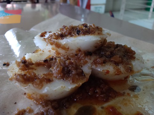
We rounded out this little hawker center with a few other items, including those chwee kueh above (not as tasty as the ones at Tiong Bahru, but good enough), as well as a pleasantly sweet oat dessert from Xi Le Ting at stall 70 (look for the stall with the old school porcelain bowls, not the dessert stall in the center). I kinda liked how peaceful this place was. Next time hopefully I can catch the porridge lady too; I recall getting a tasty yu sheng from her last time, although I can't recall specifically what it was that I liked about it.
Subscribe to:
Posts (Atom)