Fore Abbey, County Westmeath

As last Monday was such a beautiful clear day we took a trip out to see Fore Abbey. Located in the small village of Fore in rural Westmeath, Fore Abbey is one of the true wonders of Hidden Ireland, a site that should be on every must-see list for those interested in Irish history and archaeology.

Interior of the 10/11th Century St. Féichín's Church
The site was founded by St. Féichín in around AD 630, and the small monastic site quickly grew in size and importance, and received many mentions in the Annals of Ireland. Although there are no visible remains of this initial seventh century monastery (indeed the exact location of the earliest foundation has still not been conclusively proven) there is still a fine 10–11th Century church located on the slopes directly above the main part of Fore Abbey. This is St. Féichín's Church, the main part probably dates to the 10th Century, with a later chancel added in the 13th Century to extend the church. In the background of the photo above you can make out the huge lintel above the doorway, said to be one of the Seven Wonders of Fore (see below).

Most of structures forming the main part of Fore Abbey date to the period following the Norman invasion of Ireland. Hugh De Lacey ruled the Lordship of Meath (roughly speaking it incorporated today's Meath and Westmeath) from his fortress at Trim Castle. De Lacey would have appreciated the value of the monastery and the population growing around it. He had a priory established in around 1180 and gave the site to the Benedictine Order.
The Benedictine movement was extremely popular across the Continent, but there were not many Benedictine monasteries established in Ireland, and I can't think of another example as well preserved as Fore. It was constructed around a central cloister (a beautiful courtyard), with a church to the north, the dormitory for the monks to the east, the refectory to the south with its adjacent kitchen to the south-west.  
The cloister area
By the fifteenth century Fore Abbey had become vulnerable to attack by the Gaelic chieftains as it was located outside of the area of The Pale. It was attacked in 1423 and 1428, and remained vulnerable enough that there were gates and walls built to surround the monastic settlement. I didn't see any remains of the walls, but two stone gates can still be seen near the site.

Despite these raids Fore Abbey was still a wealthy place and new towers and a revamped cloister area was added in the fifteenth century.


Fore is also known for the Seven Wonders of Fore. These are:
The Anchorite in a stone
The water that will not boil
The monastery built on a bog
The mill without a millstream
The water that flows uphill
The tree which will not burn
The stone lintel raised by the saints prayers

Fore Abbey is a wonderful place, the area is steeped in history and stunning ruins that you can easily spend an afternoon wandering around, especially if you are lucky enough to be there on a fine day too. The site is well signposted (see our map for its exact location) and provisioned with a large carpark, I highly recommend a visit!

I really hope that you enjoy our blog, if you like any of our images you might be interested to learn that you can now purchase prints from http://www.12greengiraffes.com/, take a look around the site to see what we have available and to see some sensational images of Connemara by the talented photographer Muireann Ní Cheallacháin, if there is an image from our blog that you'd like as a print please let me know by leaving a comment.

Is there a historical or cultural site in your area that you'd like us to cover? Or perhaps you might like to contribute a site to our blog? I'd love to hear from you, please send me a message at info@abartaaudioguides.com


Video: The Red Bull Elements - A Relay Race Unlike Any Other

Yesterday I shared a video from the Red Bull X Alps race, which is a very unique event it in its own right. Today I have a video from the Red Bull Elements relay race, during which competitors complete in one of four multi-sport legs. In the first leg the racers row across a lake and then carry their boat to the finish line. That kicks off the second leg, which is a running stage with a mountain top finish. The next athlete in the even then paraglides off the summit to try to hit a target area below, which in turn starts the fourth and final leg, which is mountain biking up a tough trail. This looks like a really fun and demanding event. It can't be easy putting together a team as it would be difficult to find others with all of these skills. Still, great stuff from Red Bull.

Oughterard Round Tower and Church, Kildare


Usually when we visit historical sites we have done a little bit of homework and researched the basic information in advance, this is usually the best way of finding out not only the details of the site, but also any particular feature that we should look out for to ensure we don't miss anything. However our visit to Oughterard Round Tower was an occasion that proved that sometimes it's great to just pick a site off the Ordnance Survey Discovery Series Maps and turn up without any expectations as you may get a nice surprise! 

Oughterard Round Tower and Church is located between Straffen and Kill in County Kildare. The site is accessed by a set of steps and stile in the tall wall that surrounds the site. The name Oughterard derives from the Gaelic Uachtar Ard - which translates to 'High Place', the name is very apt as one of the first things you notice about this site are the stunning views of the countryside of County Dublin and Kildare that surround you. 
A monastery was said to have been founded here some time in the early 6th Century by Saint Briga. The site was recorded in the Annals as being burned by the Dublin Vikings led by Sihtric Silkenbeard in 995 AD. Later during the Norman invasions of Ireland, Oughterard was included in the vast estates given to the Norman leader of the invasions, Richard de Clare (Strongbow), by Diarmuid MacMurrough King of Leinster as part of the dowry when Strongbow married MacMurrough's daughter Aoife. Today you can see the well preserved remains of a medieval church (looks to date to around the fourteenth century) with a barrel-vaulted roof, it's adjoining rectangular tower is in a slightly precarious position and is held up by large concrete supports. The round tower now only stands approximately 9 metres high, but what is left is in good condition. It is constructed of limestone, with large granite blocks used to frame the doorway. 

The site itself is well worth a visit, with it's beautiful views and peaceful air you can really get a sense of history and tranquility. The site also holds a nice surprise that I alluded to in the opening paragraph. Before you enter the church, take a look at the gravestone marking a tomb in the wall on the right hand side. This marks the resting place of none other than the famous Arthur Guinness himself, founder of the Guinness Brewery and the creator of countless sore heads. The slab reads: In the adjoining Vault are deposited the mortal remains of ARTHUR GUINNESS late of JAMES'S GATE IN THE CITY and of BEAUMONT IN THE COUNTY OF DUBLIN ESQUIRE who departed this life on the 23rd of January A.D 1803 aged 78 years and also those of OLIVIA HIS WIFE who died in the month of March 1814 aged 72 years. They lived universally beloved & respected and their memory will long be cherished by a numerous circle of friends relations and descendants.
So if you are ever inclined to go on a pilgrimage to thank the man who created the brand synonymous with Ireland then you may find yourself in a quiet and peaceful ancient burial ground in County Kildare.

If anyone would like more information on Irish history, or if you are interested in enjoying the amazing tale of some of Ireland's superb historical sites then take a look at www.abartaaudioguides.com we provide audioguides packed with sound effects and original music to really help immerse you in history in a fun way, the guides can be enjoyed at home or at the sites and are also available from iTunes, Eircom Music Hub, Sony Music Unlimited, Amazon and Spotify. 

Thank you all for taking the time to read this blog, we really hope you find some of the suggestions for great places to visit useful. If anyone has any suggestions or comments please do get in touch by commenting below or send us an email at info@abartaaudioguides.com


Everest and Annapurna Updates


It hasn't quieted down on Everest just yet, as more climbers continue to summit, and the weather remains good enought to climb, meanwhile, over on Annapurna, the teams are moving up, getting ready for their own summit pushes.

Alan is reporting that more than 70 people topped out on Evereest over the weekend, with a few notable climbs to mention. Dave Hahn from GreatOutdoors.com managed to summit, along with his Sherpa guide Punjo Dorje, as did Canadian Meagan McGrath. Word from the HiMex Team that they managed to put eight climbers on the summit and six Sherpas as well. Amongst those climbers was Tim Medvetz, the biker and fan favorite, from last season's Everest: Beyond The Limit television show.

The scariest story of the day comes from Gavin Bates, an experienced and strong climber who was attempting a traverse from the North side without Oxygen. As he got higher on the mountain however, Gavin decided to use the O2, only to have his mask malfunction. Gavin began to suffer the effects of pulmonary edema at about 8700m and was forced to abandon his climb to return to ABC before his lungs filled with fluid. We can now report that he is safely back to ABC, thanks to the help of the Sherpas accompanying him, despite taking a fall on the descent.

On Annapurna teams have moved up to C4 according to a report on MountEverest.net. All the climbers on the North Face giong up the German Route have decided to climb together in one massive push.

Word is that Spaniard Iñaki Ochoa and Romanian Horia Colibasanu are moving up from C2 to join the others at C4, and have volunteered to break trail above that camp. The two climbers were on Dhaulagiri while fixed lines were set down, and camps were established, but now feel rested enough to contribute to cause on the upper slopes. Summit attempts should come in the next day or two.

Good luck boys. Climb safe. Annapurna can be a harsh mistress.

I'm finally finished unpacking and guess what I found! 3 pages of notes that I took when I decided to start this blog while I was in Tangier. Well, it's not the first post like I planned on it being, but, hopefully you'll get an idea where I'm coming from and an idea about Tangier too. The day before I started thinking about a blog, Roland and I were wandering around the Tangier medina and kasbah. It was my 10th trip to Morocco, probably my 6th or 7th to Tangier and I didn't recognize much-- a flicker or a glimmer here, a flicker there. And not because it's all changed or something; the memory ain't what it used to be (even though I take this great holistic memory stuff my friend Lou recommended, Juvenon.) Anyway, Roland has a great memory and he navigated us up hills and through passageways. "Don't you remember this (mega hill)"? he demanded.

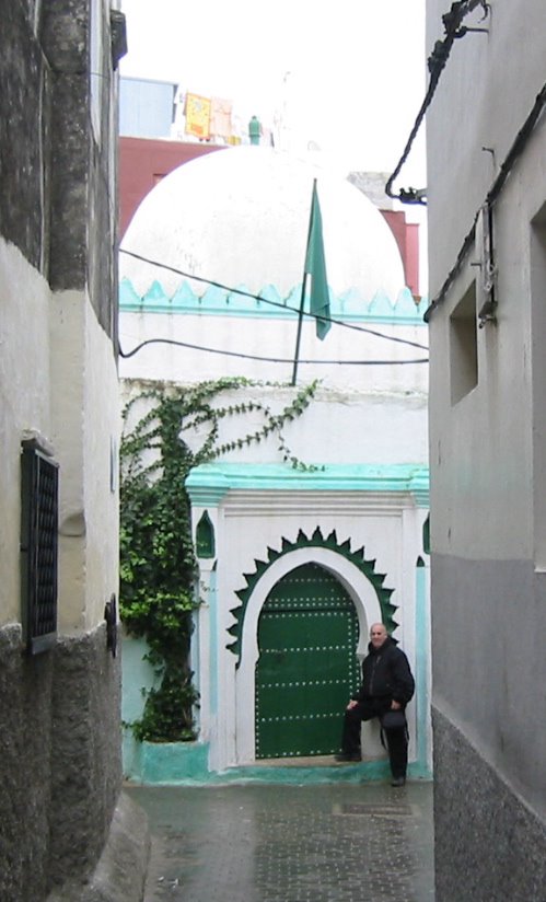
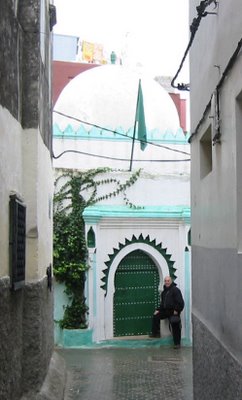
"Uh... no. Are you sure we went this way last time?" He was-- and we had. (Eventually I recalled; it just takes longer these days.) The hill leads right up into the Place du Kasbah, the place where the kasbah begins with the police station and my friend Absalaam's  little cafe (which I've only seen open exactly one time. It was closed.) Now how the hell are we gonna find Absalaam's house? Roland was undaunted. He even remembered the awesome ancient door. We both had a memory of a small, pastel mosque Matisse had painted a block from Absalaam's. (That's it with me in the photo.)

The first time I came to Tangier it was 1969. I had heard lurid things about the city-- it had a bad reputation back then, a holdover from the International City days-- and I avoided it on the way in by entering via an Algeciras ferry to Ceuta, the bit of Spain that is still left in Morocco. Dull, sleepy place, but we headed south from there and by-passed Tangier. A month later, we did enter the city of sin on the way back to Spain. It didn't impress me but I didn't give it a chance. It wasn't for years that I grew to really like Tangier. But not remembering much is what gave me the idea for starting the blog. I told Roland and he loved the idea-- and he never thinks anything is a good idea.

Allow me a quick detour from Tangier-- as though this really were the first piece in a brand new blog (instead of the seventh in a 5 day old blog)-- and I'll give you a few details about my traveler background. I hit the road for the first time in the mid-60s when I was just a kid. I think I had just turned 15 when I hitchhiked from Brooklyn to Miami Beach to visit my grandparents for Easter-- or tried to hitchhike. I got picked up by the New Jersey Highway Patrol and they made my pissed off father come and pick me up at the police station. In Bumfuck, NJ (which was like Georgia or Virginia as far as I was concerned). I figured I was gonna get a beating but instead he or my mom gave me the busfare to go down to Miami in style the next day; maybe even the same day. I lost my virginity behind the Jacksonville Greyhound terminal. I don't remember much-- a lot of black: big black tires, big black face... and I kind of blacked out when I um... you know (this isn't a porn site, so we'll leave it at that). She was so sweet and cool and friendly and I was such a nerd. I don't know if she told me her name. If I had this blog then, I'd know now.

I only spent 2 nights in Tangier this time. The ferry was like 6 hours late but we were lucky because it hadn't crossed in 3 days because of stormy weather. It only took 90 minutes once we left Algeciras. I always used to love the gradual approach from Europe to Africa, the sights, the sounds, the smells, the feeling of excitement. I didn't really feel it this time. It was drizzly and overcast. We stayed at the place I always stay there, the only decent place, the El Minzah Hotel. Some Scottish aristocrat got it going in 1930, Lord Bute. It's actually gotten quite a bit better since the last time I was there. There's even a business center on the second floor with 2 super-fast Dells ($5/hour, which is really expensive for Morocco but I didn't know that yet). It's a 5-star hotel in a country where stars are very relative; the hotel owner is probably married to a relative of the Minister of Stars. But it is the best hotel in Tangier, which is, after all, a slowly improving but still shabby port at the Northwest tip of Africa, a place of intrigue and desperation where people from Africa (all over the world, actually) come to try to smuggle themselves into Spain and the EU, where the streets are paved in gold (relatively). Some people say it reminds them of Tijuana. I'm sure it seems to some like the whole continent of Africa would like to come in order to cross over to the good life in Europe. And it's a place where the livers of that good life can cross over and have a quick look-see how the other 90% of the world lives. Someone once told me most visitors to Morocco just come for a day and never get beyond Tangier. That's a shame.

The concierge at the El Minzah told me that almost all their guests stay for one night. There hadn't been any for 3 days because of the ferry. Tangier's not really a destination any more-- at least not for more than a night-- which must be frustrating for the people running the hotel, although they seem to be trying to make the best of it. There's still an underlying seediness about it that you won't find in a real 5-star hotel but at least I don't think they'd steal a $100 travellers check left in the safe behind the reception (the way they did about 20 years ago when I stayed there once). Now they don't even have a safe behind the reception-- and I don't bother with travelers checks anymore anyway. I feel confident enough now, after almost 4 decades of travel, to keep my cash in the pockets of my relatively tight jeans.

A couple months ago when I tried booking our room on the net, the hotel was anything but receptive. Not only did my correspondent have no interest in agreeing on a decent discount, he also said we would have to participate in an extravagant Christmas Eve dinner if we booked a room. I pointed out that Expedia.com was offering much cheaper rates and he claimed they don't honor Expedia's bookings. The El Minzah, 5 stars and all, ain't much, but the drop down to the next level hotel is a far drop indeed. I booked through Expedia-- 1,125 dirhams (like $120) for a double room, breakfast included. They honored the booking and the price.

The pleasant surprise in Tangier was the restaurant scene. It's one of the few cities where there is a Moroccan middle class accustomed to going out to eat enough to support real restaurants that don't just cater to tourists. Tourist restaurants are always horrible-- bland, over-priced, pathetic... all decor and show and never anyone striving for excellence in the kitchen. The guide books all claim that the El Korsan in the El Minzah is the best restaurant in town. It's exactly the kind of place I do my best to avoid. We managed to find two really excellent restaurants we ate in. One was somewhat touristy, but reasonable and definitely oriented towards ala carte ordering, rather than forcing you into a gigantic feast, Raihani's. A little further from the tourist area we found a fish restaurant which catered 100% to Moroccans, the Andalus. It was so delicious-- real salt of the earth kind of place, very friendly and unpretentious and ridiculously cheap. Harira for 5 dirhams, not 60 or 80, for example. Hmmm... I'm drooling just thinking about the fish tagine I had!

Kilimanjaro Climb: Machame Route - Day 3


Shira Camp (3840m) to Barranco Camp (3950m)

Day 3 on Kilimanjaro is all about acclimatization. You'll get a full taste of the old adage "climb high, sleep low" as you first gain 690 meters, and then descend 580 meters at the end of the day.

Much of Day 3 is spent in the alpine desert of Kilimanjaro. You'll leave the colorful bushes, scrub grasses, and interesting plant life behind, at least for the time being, for the rocky, barren, and dry expanses of the high desert areas. You'll continue to have amazing views throughout the day as well, and the summit will loom over you as you hike, as long as the mists clear long enough for you to see it.

You'll reach the high point of the climb around mid-day, as you approach the Lava Tower, a 300 foot tall formation jutting out of the mountain that ws created by cooling lava at some point in Kili's past. The morning is a steady climb up to this point, and you'll likely have lunch in the shadow of the Tower. After that, you'll turn down hill to make your way towards Barranco Camp. But make no mistake, just because you're going down doesn't mean that the trek is easy. On the contrary, you'll be scrambling over rocks and hiking through loose rock scree that will have you watching your step at every moment. On top of that, you're likely to have tired legs from the previous days climb and the exertion of the morning, making the descent more challenging than you'd like.

There is a reward for the day however, and that's the beautiful scenery as you descend. The alpine desert will once again fall away, and you'll return to the colorful moorlands. More beautiful plants will spring up around you, and as you hike down the valley to Barranco Camp, there are a number of beautiful waterfalls. Definitely take time to look around on this stage of the climb.

Barranco Camp is easily the most scenic on the Machame Route. You'll have some amazing views of Mount Meru, Heim Glacier, and Kibo's south face. When the mist clears at night, you'll also be able to see all the way down theh valley into Moshi Town. Of course, it's not all fun and games, as you won't be able to avoid eyeing up the Barranco Wall, a 1000+ foot rock face you'll be tackling first thing in the morning.

For me, this was a good day on the trail. The morning hike up was definitely challenging and I was ready for a break when we stopped for lunch at the lava tower. The descent was certainly more challenging than I expected, and you had to watch your footing constantly, as the scree was very loose in spots and if you weren't careful, you could easily twist an ankle, or trip and fall. But the views in Shira Garden, as the valley leading to Barranco Camp is known, are quite stunning. Certainly some of the best you'll see on the whole trek.

The night before this stage I probably slept a total of 20-30 minutes. Very light dozing at best, but I still felt good on the trail. My legs were feeling a bit of the strain, but generally still felt good. I remained hopeful that a good night's sleep was just around the corner, and that the acclimatization process was going according to plan. I hadn't suffered any head-aches or nausea, although other groups we encountered certainly were. I remained optimistic.

(Photo courtesy of Colm Donohoe. It's a shot of myself, and our guides, Peter and Zawadi, at the Lava Tower.

Dodo Completes The Double-Double, Climbing Partner Missing!


I first reported on Dodo Kopold's Double-Double a while back when it was still just a plan, but word has come in that he has completed his quest to summit both Cho Oyu and Shisha Pangma in the Spring Season.

However, there is grim news to go along with Dodo's triumph. MountEverest.net is reporting that Dodo's climbing partner, Marek Hudák, is missing, and has been missing since Tuesday. Dodo and Marek were climbing on Shisha Pangma, making their summit bid, when the parted ways. Dodo continued to the top, but Marek retreated down the mountain. When Dodo returned to C2 he found that the camp had been buried in ice and that his friend was missing. The only signs of Marek were an ice axe and a glove. He hasn't been seen since the two separated on four days ago.

Dodo and the Korean team on the South face of Shisha have searched for the missing climber, but so far to no avail. The loss of his friend has put a dark veil over Dodo's accomplishments, as he has claimed the first two 8000m summits of the year. He's not stopping there either, as he plans to travel to Pakistan to summit Nanga Parbat and K2 this Summer. We'll have to wait to see if those plans change following this tragedy.

My thoughts and prayers go out to Marek's friends and family at this time.
Italian adventurer Alex Bellini has accomplished some pretty impressive things in the course of his career. He estimates that he has run more than 23,000 km (14,290 miles), competing in such races as the legendary Marathon des Sables and Alaska Ultra. He has also rowed across the Atlantic and Pacific Oceans, amongst other challenging journeys. But his next adventure may be his most demanding yet. Bellini plans to spend a year living on an iceberg as it shrinks in size and eventually disappears altogether. He hopes that these efforts will help raise awareness of climate change.

The Adventure Journal had the opportunity to sit down with Alex and ask him about this venture. He says that for the most part, he'll be completely alone on the ice, although he does plan to meet with journalists and bloggers for a time. He also says that he doesn't want to be labeled as an environmentalist, but he remains an explorer instead. Bellini hopes that this adventure will allow him to share the urgent need for us to address climate change as he documents the death of an iceberg first hand.

In the interview, Alex also talks about his inspirations for this adventure, what it was like to row across the Pacific, but run into trouble just 65 miles from the finish line and how he'll select his iceberg. In regards to that last point, he says that the iceberg is still being formed, but that it will exist northwest of Greenland "between 70°N and 74°N."

It will certainly be interesting to see how this plays out. Living alone on an iceberg for a year should provide some unique challenges, particularly as the space begins to grow smaller and smaller. You can find out more in the video below and on Alex's website. Follow him on Facebook and Twitter for more updates as well.


Alex Bellini . Adrift. LongVersion ENG from BigRock on Vimeo.

Breakfast on United Out of Logan

Omelette

Here was breakfast this morning. No, it wasn't anything special, but I sorely needed to get some food in my belly and I guess that this did it. Note to self: the Legal Sea Foods at Logan Airport features a breakfast menu in the morning, so I guess I can forget about trying out some Boston scrod when I have an early flight.
Fiery Mala

As much as I try to keep my distance from McDonald's, I was very curious about this Fiery Mala burger that they've been promoting lately, especially given Burger King's attempt at a mala burger many years ago. Frankly, I can hardly remember what BK's version tasted like, but this one turned out to be much spicier than I thought it would be, including a bit of huajiao numbingness. Still, it was also much saltier than I was expecting, and it's not exactly something that I'll want to get again, especially with that chicken patty inside. But at least my curiosity has been satiated with this quick taster today (I only took one bite).

Gear Junkie Counts Down Best Gear of the Past Five Years


Most outdoor enthusiasts know who The Gear Junkie is, even if they don't know his real name is Stephen Regenold. His columns are syndicated in a number of newspapers and magazines across the country and he has written a number of adventure travel articles for a wide array of publications. As it turns out, the first Gear Junkie article went into the Minneapolis Star Tribune five years ago this month, and to celebrate, Stephen is counting down his favorite gear from the past five years.

Each day this week we'll get two very cool gear items that impressed the Gear Junkie. Today we have, coming in at number 10, ALOKSAK bags from Watchful Eye Designs. In a nutshell, these are water proof, highly durable, ziplock bags for all of our gear that shouldn't get wet. They're great for holding maps during adventure races or for keeping you essential items dry during your next paddling excursion.

Also on the list today, at the number 9 spot, DMG BUGrip EXTREME from Icebug. The Gear Junkie sums this item quite well when he describes it as "a winter boot with a running shoe, add carbide spikes on the sole for traction". It's a trail running shoe for extreme snow and ice conditions, with built in gaiters no less.

It should be fun this week to watch the list unfold. I can't wait to see what cool gear, that I probably can't afford, occupy the higher positions on the list. :)

24 Hours of Triathlon Coming To NBC


Check Point Zero is reporting that Ian Adamson's 24 Hours of Triathlon is coming to NBC this fall as part of their World of Adventure Sports broadcasts. The race is scheduled to be run on September 1st and the show will air on October 27th.

I first reported on the 24 hours of triathlon back when Ian Adamson announced his retirement from full time adventure racing in December. But now the project looks like it's up and running, and already has a media presence with NBC. The race will be run in Cherry Creek State Park in Boulder, Colorado (where else?) and will consist of both team "relay" legs or solo competition. You can read updates in the Offical Blog and if you'd like to register click here.

More on the event as it gets closer.

I first comment on John Harlin III's new book The Eiger Obsession a week or two back when there was an excerpt from the book on Outside Online. Now, GreatOutdoors.com is getting in on the action with a brief introduction to the book as well as the IMAX film that acts as a companion to it. You'll also find two audio interviews with Harlin as he discusses what The Eiger, and climbing it means to him.

For those who don't know, Harlin's father, John Harlin II, was one of the great climbers in the Alps druing the late 50's and early 60's. He put up new routes on a number of faces, and was as well known for his climbing as his "movie star" good looks. John Harlin II had a fixation on putting up a route on the Eiger that became known ad the Eiger Direct, which was essentially climbing a line straight to the top instead of winding all over the face as the Classic Route does. While attempting just such a route, with climbing legends Dougal Haston and Chris Bonnington no less, he lost his life. The team ultimately completed the climb, but he was not there to see it. Since then, John Harlin III has always had the shadow of the Eiger looming over him, and he knw that eventually he would have to climb it. The book follows him through that climb.

I'm currently reading the book and hope to have a review up within the next week. As I'm currenlty halfway through it however, I can safely say that it's a great read with a nice mix of biography for Harlin's father as well as well as his own struggles on the Eiger as he faces those demons of the mountain that killed his father. Good stuff.

Video: Let Me Take You To The Mountain

With winter just around the corner I know many of you are looking forward to breaking out the ski and snowboards so you can hit the slopes. To get you ready, checkout this beautifully shot video that features pro snowboarders Travis Rice, Chris Davenport, John Jackson and Lynsey Dyer as they head out into the backcountry in search of the perfect line. Honestly, snowboarding videos don't get much better than this.

Book Review: On The Trail Of Genghis Khan by Tim Cope

Is there a more interesting character from history than Genghis Khan? The Mongol leader managed to unite the legendary horse clans and build the the largest contiguous land empire that the world has ever seen. The Great Khan was a legendary leader, a fearsome warrior and an unrelenting enemy. More than 700 years after his death, he still casts a large shadow over the Mongolian people and his mark on history is undeniable, altering the destiny of two continents.

Of course, the Kahn and his Mongol Horde were able to accomplish great things because they were perhaps the greatest horseman to ever live. It is with that spirit in mind that Australian adventurer Tim Cope set out to accomplish something that hadn't been done since the time of Genghis Kahn himself. With little previous experience in the saddle prior to setting out, Cope launched a 10,000 km (6000 mile) journey starting in Mongolia and ending in Hungry. An expedition that he chronicles in his new book, On The Trail Of Genghis Khan.

Before he ever launched this epic excursion, Cope new he was in for a challenge. After all, he was an inexperienced rider with thousands of miles of open steppe to conquer on his own. The trip began in June of 2004 and would ultimately take him three years to complete. Traveling with a number of horses and his loyal dog Tigon, he faced harsh and difficult climates, wild wolves, horse thieves and a host of other challenges. He also met some incredible people and was continually surprised and humbled by the hospitality and kindness of the strangers he met along the way. Tim's journey was as much about finding himself on the trail while following in the footsteps of a legend.


Cope's new book takes readers along for the ride as he wanders across Mongolia, Kazakhstan, Russia, Crimea, the Ukraine and finally Hungary. The story is a compelling one for anyone who enjoys a good tale of adventure but Tim's writing style draws readers in even more. It is a wonderful mix of his personal experiences framed against a historical backdrop that gives us a glimpse of what the Kahn experienced when he made a similar ride centuries earlier.

Reading On The Trail, it is impossible to not get swept up in Tim's infectious sense of adventure. His story is an amazing one, but he also approaches it in such a way that you'll think that it might be possible for you to attempt an epic adventure of your own. That's the kind of inspiration that Tim creates through his writing, which is at times very sensitive and thoughtful in its approach. If the writing were less compelling, the 450+ page book could run the risk of feeling as long as Cope's journey across Asia and Europe, but fortunately that isn't the case. It is a real page turner that will leave you staying up later than you intended so you can read "just one more chapter."

On The Trail Of Genghis Kahn is available in bookstores now and is wonderful read for anyone looking for a grand adventure. With the holidays fast approaching, it would also make a great gift for your favorite adventurer or traveler. If you've ever dreamed of escaping to a far off, remote destination with hundreds of miles of open space all to yourself, you'll likely appreciate what Tim has accomplished. His tale is the very definition of the "epic" and by the time you finish reading it, you'll be ready to set out on  your own journey. That's what a great book is all about.


Hore Abbey, Cashel, Co. Tipperary

Hore Abbey (also known as St. Mary's Abbey of the Rock) sits both literally and figuratively in the shadow of the mighty Rock of Cashel in County Tipperary. Although the Rock of Cashel is one of the most visited heritage sites in Ireland, very few spend the extra time on a short walk to visit the wonderful Abbey below.

The name Hore Abbey has a number of possible derivations - the first is that the name 'Hore' comes from 'iubhair' Gaelic for Yew Tree. Another theory suggests that the name refers to the dull grey coloured tunics that the monks wore.

Hore Abbey is a Cistercian monastery, and most of the visible remains date to the fourteenth and fifteenth centuries. You can still see the well preserved remains of a refectory, a large church with nave, chancel, and transepts all in good condition. Each of the transepts has a small chapel, and you can see the remains of an archbishops tomb just north of the chancel.

The cloisters are in a very unusual position, usually the cloister is always positioned to the south of the church - however at Hore Abbey they are positioned to the north. Possibly because the Rock of Cashel is so prominent to the north, they wanted to maximise its impact.

 Local legend has it that the Abbey was given to the Cistercian order in 1270 AD, as the Archbishop of Cashel, MacCearbhaill, had a dream that the Benedictines [who were the original owners of the site] were plotting against him. He drove the Benedictines from Cashel, and invited the Cistercians to take their place.


The last Abbot of Hore Abbey was Patrick Stackpole, he had held the position for several decades, but peacefully surrendered the Abbey to the Crown Forces during the Dissolution of the Monasteries in circa 1540. The lands were granted to the powerful Butler Family, and were eventually transferred again by Queen Elizabeth Ist to Sir Henry Radcliffe, Earl of Sussex.


If you are visiting the wonderful Rock of Cashel, do allow an extra little bit of time to view the wonderful remains of Hore Abbey, as an extra incentive you also get a great view of the Rock from there!

If anyone would like to learn more about the history and legends of the Rock of Cashel and Hore Abbey you can download our audioguide from www.abartaaudioguides.com


Ok, yes, I know, I said I was out of town and wouldn't be updating, but I had some time this afternoon, and decided ten bucks for Internet access in my hotel room was probably worth for me to get back in touch with the world.

I found this article over at National Geographic Adventure to be very interesting and sad at the same time. It tells the tale of Elisa Santry, a 16 year-old girl from Boston who was a member of the Outward Bound Program. She was participating in a 22 day hike across southern Utah when she went missing. After searching for her for hours, the guides and other members of her team found her dead on the trail, her pack still on her back.

Elisa's death opens a lot of questions about the 46 year old program that is amongst the best known youth wilderness training programs in the United States. But how did one of these young people get left behind on the trail? How come no one noticed until they stopped to make camp? And how did she get into a position where her life was threatened while hiking? Were there signs of her struggling on the trail? If so, why were they ignored?

The article notes that this isn't the first death in the Outward Bound Program. In fact there have been 24 fatalities in it's history, despite claims that safety is the number one concern. Of course, this has put the spotlight clearly on the leadership of the organization, and their policies for taking care of the young men and women in their care.

I don't know about you, but for a program that has been around for 46 years, 24 deaths seems like a lot! That's more than 1 every two years over the course of the life of the program, although it should be noted that this is the first death in ten years. Lets hope that some changes are made and good judgement prevails here, but those questions remain, and someone needs to answer them.

Thanks for the tip on this one Ryan!

Prepping For the Fourteeners


So you live in Colorado, and the weather is starting to turn for the better, and you've decided that this year, you're going to climb at least one of the 54 fourteeners in your state. (That's mountains of 14,000 feet or better for those just joining us) Well, The Denver Post is here to help with some great tips on preparing for a high altitude hike.

They recommend making a number of smaller hikes first if you are not an experienced hiker or use to spending time on the trail. Going from 5000 feet to 14,000 feet in one day can be dangerous the article warns, and you never know for sure what how your body will react to altitude. They also suggest stretching, doing yoga, lifting weights, and a good cardiovascular workout in preparation for your climb.

Other tips include waiting until mid-June to avoid snow and sudden bad weather, which can be common in the mountains. Bring the right gear for the day and know how much water, food, and other items you'll need to take with you. And finally, don't be afraid to turn back. Altitude can do odd things to you, and the weather can change very quickly, so play it safe and don't risk injury or worse. Finally, they also list their "Ten Essentials" of gear that should always be in your pack. Good advice all around.

Thanks Tom!
Last year a team of paddlers kayaked the length of the Amazon River, source to sea, covering 4200+ miles (6760 km ) in the process. The expedition was called The Amazon Express and we followed it very closely here on the Adventure Blog as the paddlers made their way through some incredibly difficult and challenging areas on their way to making history. It was the first time that anyone had managed to kayak the entire length of the river before.

Now, the team is hoping to produce a documentary about their adventure and they've launched a Kickstarter campaign to help raise funds to do so. Unfortunately, I only just learned about their efforts in the past few days and since I've still been digging out from my travels over the weekend, I hadn't had a chance to post about this sooner. As I write this, there are only a few hours left on the clock for this to get kickstarted and they are well below the funding they were seeking. Perhaps they'll give it another go, but at the moment it looks like that barring a miracle of some kind, this documentary won't getting made. Still, the video below gives you an idea of what they have in mind. Hopefully they'll find the funding they need. I'd definitely like to see this film at some point and I can't be the only one.


More from the Salt Lick in Austin

Salt Lick

It was good that food from the Salt Lick was being served for lunch today, as I haven't eaten from these guys in a very long time. And I'd totally forgotten about how much I loved that coleslaw with those celery seeds. Franklin definitely still has the upper hand on the brisket though.